Rosscot Island
This article is a Work in Progress and will be finished soon™
Geography
Natural Riches
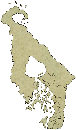
The few areas that have been throughly explored in Rosscot island show a rich environment, with lush forests, internal lakes and seemingly a delta approaching the south coast.The People of Rosscot Island
Rosscot is part of the section of the Haan Archipelago known as the "Savage Isles", separate from the rest of the islands for the hostility of their inhabitants: Any ship spotted by the natives will be attacked, plundered and the passengers killed on sight or captured never to return.While it is known that societarians do inhabit the Savage Isles, not much could be recorded about their identity, customs or settlements.
No permanent settlement from the natives has been identified in Rosscot Island.
Rosscot Camp
During the year 2981 E.Alz, a team of Dhalmanite explorers led by Rosscot Nouverre managed to get to the island without incident and set up camp there.They were able to send information and supplies back and forth with the Republic of Dhalmain for a total of two years, until their communications suddenly stopped and all ships sent their way failed to come back. Eventually, a delegation was able to get close enough to find that all traces of the camp visible from the coast had dissapeared.
The fate of the camp and its settlers remains a mystery.
Most of the knowledge about the island is owed to this expedition, for which the land was named Rosscot camp in honour to the crew's leader.
Type
Island
Location under
Included Locations
Inhabiting Species


Comments