Karte Island
Located to the far east of the Haan Archipelago, the island of Karte is the biggest on the archipelago, spanning roughly 650 kilometres in length between its furthest points. It is closest to the coasts of Ruh and Thaur.
The island's whole territory is controlled by the Kingdom of Karte with the capital City of Dia located right between the south end of the Chalk Expanse and the north end of the desert, and just south of the junction of the rivers Tantalej and Termatron.
The middle area contains the only sandy desert of the archipelago with several small salt flats inside of it. The east side of the island contains a big mountain range, and trapped between it and the desert is a smaller white forest. The southwest area contains a dense, big forest.
Most of the areas around those specific formations are grasslands and small hills.
This incredible area is home to a lot of other record-setting sized life forms and formations, such as the tallest tree, the biggest bird, and the biggest waterfall formation as well as an incredible diversity of species.
The Kartian people hold the belief that rivers have sentience and so they hold them in special regard in their lives.
All rivers in Karte are named starting with a "T" sound. Some examples of important Kartian rivers are the Tantalej, Termatron, Toxapactos, Treblin, Tismasul and Tiranibroah.
The Chalk Expanse is not only a big source of tourism to The Mightiest Roar and other points of interest, but also the only source of several raw materials such as the fruits and wood of towering watchers and the fibres of the rare lilac silk.
The mountain range is rich in gold to the south, such as around the area of the mining town of Blest, and the desert holds a much safer way to harvest many other minerals rather than risking encounters with the islands' tetsus.
The Kartian salt flats are almost the sole source of salt in the entire archipelago.


 The Kartian people are a relatively homogenous society, more independent economically and culturally from the rest of the islands than the rest of the archipelago.
They have been governed for two centuries by the Kingdom of Karte, that replaced their previous presidential system.
Instability in the Kartian monarchy under the rule of King Rastapuj led to a civil war that the country is just concluding.
Geography
Karte contains many biomes on its extensive surface, the most well-known of it being the Chalk Expanse, a massive white forest on its north half.The middle area contains the only sandy desert of the archipelago with several small salt flats inside of it. The east side of the island contains a big mountain range, and trapped between it and the desert is a smaller white forest. The southwest area contains a dense, big forest.
Most of the areas around those specific formations are grasslands and small hills.
The Chalk Expanse
The Chalk Expanse is both the biggest woodlands area and the biggest of the white forests in the Haan Archipelago.This incredible area is home to a lot of other record-setting sized life forms and formations, such as the tallest tree, the biggest bird, and the biggest waterfall formation as well as an incredible diversity of species.
Karte's Rivers
Karte is traversed by several long rivers, especially in the northwest areas where these can cover a 200km stretch from the mountains to the coast.The Kartian people hold the belief that rivers have sentience and so they hold them in special regard in their lives.
All rivers in Karte are named starting with a "T" sound. Some examples of important Kartian rivers are the Tantalej, Termatron, Toxapactos, Treblin, Tismasul and Tiranibroah.
Natural Riches
Karte is an island full of all kinds of important natural resources thanks to its biodiversity and extension.The Chalk Expanse is not only a big source of tourism to The Mightiest Roar and other points of interest, but also the only source of several raw materials such as the fruits and wood of towering watchers and the fibres of the rare lilac silk.
The mountain range is rich in gold to the south, such as around the area of the mining town of Blest, and the desert holds a much safer way to harvest many other minerals rather than risking encounters with the islands' tetsus.
The Kartian salt flats are almost the sole source of salt in the entire archipelago.
Native Fauna
Karte is home to an extensive range of creatures. The most popular Kartian beast is probably the Herald's Gnaw, featured in many shields and icons across the archipelago.
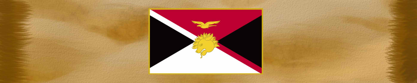
However, for the natives, the most representative creatures are the Alcholoh and the Red Gnaw, both only found in this island and represented in the country's flag. Other important creatures endemic to Karte include the hirschmall, doisu and tetsu.
The licern, originally native to Thaur, has successfully formed feral populations in the island after being brought as domestic livestock.
Alcholoh by Naelín
Herald's Gnaw by Naelín
Doisu by Naelin
Red Gnaw by Naelín
The people of Karte
Karte is predominantly inhabited by societarians of the scaly subspecies.
Though they range a large variety of phenotypes, they have the highest concentration of snake, crocodilian and skink phenotypes among the scaly populations. A small minority of Kartians are furry societarians, all of deer-related phenotypes, that immigrated from Thaur Island and took the power of the island several centuries ago in 2822 E.Alz. This group is known as the Regal Stag Family and makes a big section of the Kartian aristocracy.
Though they range a large variety of phenotypes, they have the highest concentration of snake, crocodilian and skink phenotypes among the scaly populations. A small minority of Kartians are furry societarians, all of deer-related phenotypes, that immigrated from Thaur Island and took the power of the island several centuries ago in 2822 E.Alz. This group is known as the Regal Stag Family and makes a big section of the Kartian aristocracy.

They have been governed for two centuries by the Kingdom of Karte, that replaced their previous presidential system.
Instability in the Kartian monarchy under the rule of King Rastapuj led to a civil war that the country is just concluding.

Island of Karte by Naelin
Type
Island
Location under
Included Locations
Included Organizations
Owner/Ruler
Owning Organization
Related Ethnicities
Inhabiting Species

Danae by Naelin


I love it! Especially all the animals! This article might really motivate me to write better geography articles :D