Sangsalgu
Demographics
Sang leadership has an unconventional perception of city management. Rather than limit citizenship within a specific area as other city states do, sangs expand the city limits far beyond what would be considered reasonable. Because of this, Sangalgu 'grew' to encompass leagues of land where there are a diverse amount of peoples who owe their allegiance to the Sacred Precinct.
Ethnic Sang conjugate around Sangsalgu proper with many taking on roles as pochteca or warriors that take them to other parts of the empire or outside it. Teeks, Teiks and peninsular peoples, likewise, settle themselves along the shores and floating land.
There is also a minority of Tinge residents who are the descendants of captives during the Wight War living in Sangsalgu as integrated citizens.
Government
For all intensive purposes; the leaders of Sangsalgu lead the Triple Alignment. It possesses a sophisticated hierarchical structure where at the top is the figure of the emperor. The emperor resides in the capital city and extracts tribute from the other city-states.
It is not too central an authority, as those provinces outside of Sangsalgu Proper are given the autonomy to conduct local affairs, so long as they continue to be profitable. Campa nobility are instructed to form many councils within their own districts with varied responsibilities to different administrative sectors towards the daily logistics of the citizenry. Among the far flung nobles themselves, arrangements are usually made to send the most capable in the Campa to go and represent them in the Sacred Precinct.
Provincial Structure
There are two types of provinces: Strategic and Tributary.Strategic Provinces
Strategic provinces are the conquered territories that were incorporated officially into Sangsalgu's city limits. In practice, however, they became subordinate client states which provided tribute (reclassified as taxes) or aid to the state under "mutual consent". 1. Acatlan
2. Ahautlan
3. Ayotlan
4. Chiapan
5. Chiauhtlan
6. Cuauhchinanco
7. Huexotla
8. Ixtepexi
9. Ixtlahuaca
10. Miahuatlan
11. Misantla
2. Ahautlan
3. Ayotlan
4. Chiapan
5. Chiauhtlan
6. Cuauhchinanco
7. Huexotla
8. Ixtepexi
9. Ixtlahuaca
10. Miahuatlan
11. Misantla
12. Ocuituco
13. Tecomaixtlahuacan
14. Tecpantepec
15. Temazcaltepec
16. Teozacoalco
17. Teozapotlán
18. Tetela by the river
19. Tetela
20. Xalapa
21. Cēmpoalātl, or Zempoala
22. Zompaynco
13. Tecomaixtlahuacan
14. Tecpantepec
15. Temazcaltepec
16. Teozacoalco
17. Teozapotlán
18. Tetela by the river
19. Tetela
20. Xalapa
21. Cēmpoalātl, or Zempoala
22. Zompaynco
Tributary Provinces
Tributary provinces are mandated to provide regular tribute to the empire and are not considered as part of the capital. A province can be labelled as tributary if they have proven to be rebellious in the past or if they tend to contribute the most in revenue. For example, the market cities are so called because they give the state so little trouble and are too profitable to reclassify and reduce the amount of earnings the state receives. 1. Atotonilco of the Plaza
2. Greater Atotonilco
3. Lesser Atotonilco
4. Axocopan
5. Cihuatlan
6. Coixtlahuaca
7. Cotaxtla
8. Cuahuacan
9. Cuernavaca (formally Cuauhnāhuac)
10. Cuilapan
2. Greater Atotonilco
3. Lesser Atotonilco
4. Axocopan
5. Cihuatlan
6. Coixtlahuaca
7. Cotaxtla
8. Cuahuacan
9. Cuernavaca (formally Cuauhnāhuac)
10. Cuilapan
11. Huatusco
12. Huaxtépec
13. Malinalco
14. Ocuilan
15. Oxitipan
16. Quiauhteopan
17. Soconusco
18. Tepeaca
19. Tepecoacuilco
20. Tlachco
21. Tlacozauhtitlan
12. Huaxtépec
13. Malinalco
14. Ocuilan
15. Oxitipan
16. Quiauhteopan
17. Soconusco
18. Tepeaca
19. Tepecoacuilco
20. Tlachco
21. Tlacozauhtitlan
22. Tlapacoyan
23. Tlapan
24. Tlatlauhquitepec
25. Tlaxiaco
26. Tochpan
27. Tochtepec
28. Toluca
29. Tzicoac
30. Xilotepec
31. Xocotilan
32. Yoaltepec
23. Tlapan
24. Tlatlauhquitepec
25. Tlaxiaco
26. Tochpan
27. Tochtepec
28. Toluca
29. Tzicoac
30. Xilotepec
31. Xocotilan
32. Yoaltepec
Defences
Sangsalgu is guarded not by walls; but by men and water. One thing to keep in mind about their rise is that it was explosive. A few centuries earlier, they were but vassals to the Ocumtit on the eastern shore .
Man Power
That the Sang Empire is truly an alliance between the dominant groups on the western side of the valley basin and a few allied groups on the eastern side; with an upstart military power on an island between them. This explains the lack of massive fortifications in Sangsalgu proper. The city really expanded only after it had already secured the support of the biggest military and political powers in the region. True threats are beyond the Valley of Man, not necessarily within it.Choke Points
And even when domestic conflicts arise; the fact that Sangsalgu is on a series of islands accessible only by canoe or causeway, and that it has grown into the largest polity in the region by far, meant that routes to attack it are limited. The causeways themselves have sections that can be removed to isolate it from the mainland. Towers and strong points are positioned at regular, and irregular, intervals and are frequently manned by troops. There are also certain districts outside Sangsalgu Proper that are small enough and possess the means to build modest fortifications or already had them before they were annexed into SangsalguEmbankments
Sangsalgu was built as a city of canals, not walls, but that does not mean the people and their leaders have taken no such precautions. In the early phases of its existence, there was a raised sewer line that circled three sides of the Sacred Precinct, leaving open to the lakeward facing side. Built of stone with an undulating facade, it was initially twice the height of a normal man, and so named the “Snake Wall”. Though its purpose was to help in fertilizing the chinampas, this wall gradually and unevenly began to sink in the marsh till the citizens just thought of it as another raised causeway. But the near defeat at the Green Battle showed how vulnerable Sangsalgu proper was from the lake’s direction, so plans were made to update the city’s defenses. They started by piling atop the old sewer and closing the ends into a proper wall that is, again, twice a man’s height. And with the flowing sewage at the base; planners thought it a last resort to include hidden gates that might flood conquered parts of the city in waste; should it come to it. As a whole, the primary city defense is still its surrounding allies and the lake.Industry & Trade
Tillage
Agriculture is the single most important industry with Sangsalgu, especially in Sangsalgu proper. A variety of corps are grown but the most important are maize, squash, and beans. These three crops, known as the “three siblings” are planted together since they keep the nutrients in the soil. Any surplus produced is used to trade for other goods.Tribute
Tribute from conquered city states contributed considerably to the capital's wealth and constant wars were fought to ensure its steady supply. Thus the empire constantly waged battles against their neighbours to ensure a steady supply of tribute and captives.Trade
Sang traders are a social class onto themselves. Travelling merchants trade between different parts of the empire and sell the surplus goods of one place to the other. These travelling merchants also served as a source of communication between different regions, annexed or not. They traded in food, garments of various kinds, feathers, slaves, and even precious metals. Some also traded exclusively for the nobility and sold their surplus tribute in the marketplace.Infrastructure
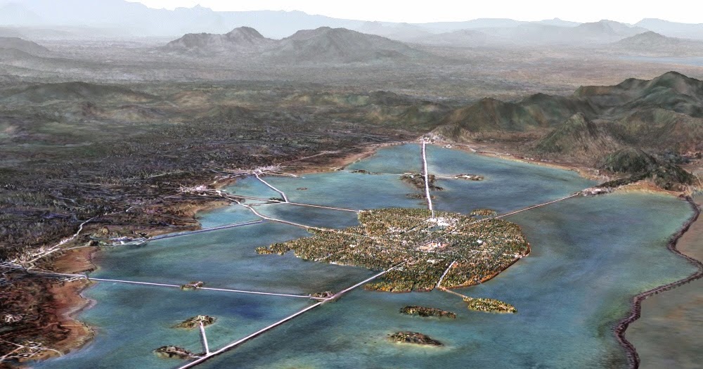
Sangsalgu Proper
The city was built on a series of black gravel islands on the western edge of Lake Coco. In a smaller portion of waters dubbed the Mixed Lake for the salt water mixing with fresh spring water. The capital is laid in a dense grid of buildings sectioned off via the streets, canals and larger roads into 16 campans, which are further divided into 40 calpōlli. These districts hold commoner families in common homes and schools; and are the responsibility of one the forty.
1.Atzacualco
2. Cuepopan
3. Moyotlan
4. Zoquiapan
5. Tetamozolco
6. Ocumtit
7. Coltonco
8. Tenayuca
Tolnahuac, Motecuzoma, Bootshaflen
2. Cuepopan
Nonoalco, Tlatelolco, Palast
3. Moyotlan
Aztacalco, Ahuehuetlan, Axayacatl
4. Zoquiapan
Moltecuzmx, Mixiuhca
5. Tetamozolco
Leugimnats, Feather Works, Zacatlamanco
6. Ocumtit
Ocumtit, Popotla
7. Coltonco
Xocotitla, Atepehucan
8. Tenayuca
9. Acatitlan
10. Teopanzolco
11. Tetzcotzinco
12. Huexotla
13. Tepoztlan
14. Calixtlahuaca
15. Coatetelco
16. Malinalco
Mazatzintamalco, Nextitla, Chapoltepec
10. Teopanzolco
Tepetlatzinco, Ticomac
11. Tetzcotzinco
Ticomac, Zacahuitzco, Tepepilco
12. Huexotla
Asuncion, Zurcanta, Iztacaco
13. Tepoztlan
Atlazolpa, Acolco, Apatlaco
14. Calixtlahuaca
Coyo, Atoyac
15. Coatetelco
Hutixachtecatl, Itztpallapan, Tizapan
16. Malinalco
Huitzilopochco, Mexicaltzinco
Sacred Precinct
The walled center of the city encompassing a huge plaza surrounded by a dozen religious and governmental buildings. Dominating the precinct’s skyline is the as-of-yet-incomplete great temple of power . In front of it, and in the precinct center, is the round pyramid to the war god. There is also a ball court, a noble school and luxury apartments for administrative nobles arrayed around the remaining grounds.Causeways and Canals
Sangsalgu’s causeways are raised roads that allow the people to easily travel over the swampy and wet areas of the area. There were three major causeways that led from the island city to the mainland. The ways were built and named after the geographical features close by: Tepeyac (also called the Great Causeway), Tacuba and Iztapalapa. Connected to all three, are the major roads of Nozwa, Coyot, and Tesh that circle around the entire city proper. There are also many removable wooden bridges built into the stone causeways that allow for small boats and canoes to travel through them. These bridges can also be removed when the city is being attacked to slow down or trap enemies. The Sang also built many canals throughout the city. The canals act like water roads that allow people to easily travel around the large city in boats.Aqueducts
Co-located besides the four main streets and three main causeways, to deliver the city’s fresh water from distant springs via paired ducts lined with terracotta bricks. This allowed for continuous water flow, as maintenance can be made on one pipe while the other carries on.Marketplace
There are markets scattered throughout the city where people would trade goods and food. But some are more famous than others.- Old Market: Nestled within the first settled part of the city; it is the main marketplace where up to 40,000 people would visit during feast days to buy goods and food for celebrations.
- Night Market: To avoid overcrowding the causeways and canals in the city’s heart, the government set aside the land at front of the first and largest causeway as a depo for foreign traders. The merchant class in Ocumtit have made great profits in setting up shops and services to accommodate them. Ocumtit’s nobles, looking for new revenue sources, sponsored several plots of land into ventures that further expanded the Night Market into the largest bazaar of Sangsalgu.
- Market Temple: Resting on its own island; the titular temple is the one to Yacatecuhtli (the nose lord). Formerly a palace to the only other rival monarch on the lake, its large rooms and spacious quads now hold court to daily shops and stalls. Most rooms, particularly on the lower 4 levels, are sectioned into smaller claustrophobic rooms full of various wares, so business is typically struck and finalized in the open crowded hallways. Unlike the rest of the complex, the upper 3 floors kept the décor and grandeur and uncluttered apartments to service the nobility and the rich. Servants are usually sent to acquire products for their masters, but the temple uniquely services the elite who can make the climb and spend a day.
- Oxxo: A collection of chinampas positioned to the south-west of the Precinct and mostly controlled by one family. The stores and storage buildings are very close together, not a single tier structure within. All are either double or triple tiered; even a few quadruple floored buildings erected to meet demand for space. Though mostly trafficked by foreign merchants, 60,000 people visit Oxxo every year.
- Feather Works: Where artisans peddle their crafts to the public and where the rich contract their commissions. Its formal name is Tetamozolco Docks, as it lies in the Tetamozolco District. It is more often referred to as the “Feather Works”, not just because most of the city’s amantecas work there, but because the other districts in the distant peninsulas wanted to be able to ride their canoes onto the shops, buy their things and be able to return to their homes in a day. So the Feather Works layout took on that of a feather. With the Tetamozolco Causeway acting as the anchoring spine and projecting stable ground outwards, with spaces left in between for the lake to fill in. To continue to meet with demand, additionally modified chinampas were added to the outer fringes of the ‘feathers’ to float and service temporary store houses for outgoing merchandise.
Assets
Chinampas
A chinampa is a small, stationary, artificial island built on a freshwater lake for agricultural purposes. It consists in building up a number of narrow islands, each averaging some 20 to 35 feet wide and some 325 to 650 feet long, using layers of vegetation, dirt, and mud. They can be made permanently fastened to the shallow lake’s floor or made to float. The lake provides the chinampa with moisture laden with composts that irrigate and fertilize the island’s soil. However, special care and monitoring is done to ensure that the salty parts of the lake water to not find their way into the chinampa’s soil. Chinampas were initially located on the outskirts of the young Sangsalgu and sometimes extend into the surrounding body of water where the irrigation for them would be sourced from. Now; as the city has expanded, rather than move them out further, planners decided to fix the old chinampas in their place and build new housing and public facilities around them. The largest collection of the inner chinampa areas are located in the Cuepopan Campa, with further scattering about the other three central camps. These tiny mounds of land were very productive for growing crops such as beans, squash, avocados, tobacco, hemp, and peppers, and (most important of all) corn; to supply the city's needs. It is the policy of Sangsalgu to put aside 15 months' worth of nutritional crops every year. Private farmers farm chinampas on the shallow lakes on the new city outskirts; filled with mud or wet soil formed into a square. Each chinampa is surrounded by canals of the water formed in between them. Dams and complex systems of irrigation are built to sustain crops essential to the people. These patches of swamp farming blocks are around 8.5 feet wide and 100 feet long and separated by the traditional willow roots. These outskirt chinampas can be seen from the mainland in the Ahuehuetlan and Mazatzintamalco Districts and Coltonco Camp.Dikes
Sangsalgu’s dikes are long walls or embankments built to prevent flooding or mixing of the city’s water reserves. There is almost no where one can look and not see a Sang dike that makes the city possible. Often times, its dikes are so constructed as to double as extra pathways for the citizenry, or certain individuals to travel.Grass Dike
The longest, running some 70,000 feet north-south and creating Mixed Lake; it is composed of three lays of grass-tree trucks on either side and barriers of raised earth in-between. This dike is three wagons wide and doubles as a short-cut across the lake between the coastal district for a select few.
Stone Dike
The sturdiest, connecting with the northern end of the grass path towards the mainland and further separating the Mixed Lake from Lake Lightning in the north-east.
Traders Plank
The ricketiest, joining the holdout on Tenula with a clear path to the rest of Sangsalgu through the southern districts. Not as well maintained as others; it is the most profitable since it shortens the distance merchants need to travel. So much so that complaints of the traffic loads are undermining its usefulness to separate out the salty waters.
Guilds and Factions
Council of Four
The inner circle of elites and nobles who advise the Emperor. These men are typically the major generals of the Cuachicqueh, Cuāuhtli, Ocēlōmeh and Otōntin.Pochteca Groups
There are several communities throughout the city who drive the economy and are most concerned with trade relationsSpeaking Council
The name originated from the advisory council to the only other island rulers on the lake. When the Teeks were absorbed into Sangsalgu, young teeks took up the name and became a loose group of intellectuals with unofficial political pull for particular governmental decisions and issues. The idea has spread to the rest of the city where many people without affiliation express their views.Herald Gangs
Herald gangs are a group of loosely affiliated youths within a given campa who deface property, harass rivals and spread rumours at the instruction of the host campa nobles. They serve as an extended tool for rival families to exert soft power against their political enemies. But sometimes, the gangs themselves initiate physical conflict amongst themselves which has brought the families into open conflict.History
Sangsalgu's rise is the tale of the ingenuity of a scattered people. Though the Sang entered the valley as a warrior people, they wound up as refugees dependent on the patronage of others. At first, they had to contend themselves with tasks laid out for them by their overloads and subsist on the weeds that grew on the lake bed. Overtime, they came into their own as both political and geographical center of the valley.
Tourism
Botanical Gardens
Originally intended as a state sponsored effort to reliably secure the early settlement’s food sources. The site has since switched to growing trees, scented flowers, useful herbs and other luxury crops.Aviary
A purpose-built enclosure primarily for the tribute offerings of birds sent by the College of Birds every year. But even this, is not enough to fill the four dozen rooms within. The aviary is a source of state revenue since it is here that birds trained to talk people speak are bought and sold to trendy collectors.Zoo
Some of the animals housed inside include foxes, coyotes, eos, little brothers, monitors, lizids, armadillos and snakes. The symbols of the city state: jaguars, pumas and panthers are kept here for most of their time.Aquarium
The aquarium holds much and more of fresh and salt water creatures, too numerous to name, in separate ponds a short distance away from the Sacred Precinct.Architecture
As far as creating impressive temples and pyramids, the Sang are not particularly noteworthy. Their water works do distinguish them and put them on the lists of remarkable engineers. However, by necessity, these projects are mostly hidden from view.
Higher End
The as-for-mentioned temples are majestic and powerful structures built stone by stone. As are their famous the ball courts, the homes of the rich and public living areas. The Sang, if they could, would adorn their buildings with artistic renderings and sculptures, but usually in a style similar to that found in the garden cities. The, still incomplete, Temple of Power is meant to rise to the challenge. But even so, it does not appear to match the utility of the Dragon Walls surrounding several garden cities or the Step’s Pulleys; the expansiveness of the College’s Sun Pillars; or the awe of the Rangers’ Stone Sails or the Courtiers’ many super structures.Lower End
Although, there are adequate quarries within the territory of the Triple Alignment, the biggest problem in building as their rival do, is the lack of suitable wood. Therefore, moving stones and making plaster and certain paints is a very expense prospect of valley basin settlements to undertake. While the rich may do so at their own expense, commoners have devised a way to use by-products and other less valuable resources to build their homes. As a result, most building, especially in the outer areas are made from bone white salt mixed in with purple salt, to reduce the risk of ones’ home dissolving away. Visitors have always commented on and asked for the significance of the ‘purple branches’ wrapped around the common home, but that is simply the final result of mixing the different types of compacted salt into a wall. As a result, the colour purple is largely associated with those of middling financial standing.Geography
Marshy Islands
Built on top of small islands and marsh lands. It is the largest city in the world; although some might take this to be misleading. It is this area, given to the Sang, where Sangsalgu would grow and stretch to the lake shores. This swampy land is Sangsalgu proper, where the Sacred Precinct holds the most direct control and ethnic Sang tend to congregate.Gravel Islets
Also called the Black Salt Islands, this confined collection is what had made the Mixed Lake so worthwhile in the past. Sangs of the past settled nearby to mine the valuable mineral that burst from the ground, as part of their obligation to Ocumtit.Peninsulas
From Sangsalgu proper several mighty bridges extend to the Colhuacan and Tenula peninsulas to the north and south respectively. Colhuacan is leagues of agreeable land with many pre-established settlements, peaceably integrated, and organised into three districts. The land control in Tenula, by comparison, is short, rocky and contested but vital to reestablishing influence in the western lake shore.Eastern Lake Shores
Half-a-day's worth of canoeing separates Sangsalgu proper from its mainland districts. Not as densely populated, these camps are self-sufficient and produce most of the non-luxury items Sangsalgu exports. The eastern coasts are an expansive plain of yellow grass and tough soil, called Dragonsgrave, and watered by the many fresh water rivers that flow down the Bad Step via the snow melt.Natural Resources
There is not much to be said for Sangsalgu proper in term are available resources. Given the swampy ground of the capital, only the chinampas made the lake bed fertile. Otherwise, Sangsalgu would not exist at all. What one might not think as a resource, is the existence of Sangsalgu itself. Its many market centers and elaborate waterways make it easy to transport and trade in goods and services via the connecting rivers, even to settlement further inland.
Alternative Name(s)
- Three Gates
- Five Lands
- Place of Seven Cities
Type
Capital
Population
1,000,000
Inhabitant Demonym
Included Locations
Owning Organization
Related Tradition (Primary)
Related Professions
Institutions
Past Wars
Remove these ads. Join the Worldbuilders Guild


The detail and depth in this article is awesome. Nice work!