Mountain River
by hughpierre
Geography
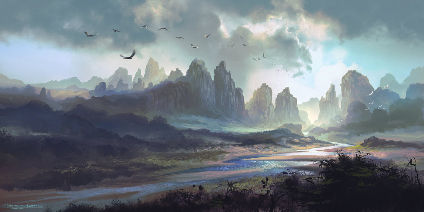
The Mountain River is the main river system in Tawantinsuyu. It's flow south into Antisuyu from the highlands of Chinchaysuyu is what carved the sacred valley into being and whose waters feed many upstream terrace farms.
In the northwest, a network of rivers form the inter-regional borders between Chinchaysuyu, Messa and Qullasuyu that are themselves sources for the river.
Ecosystem
The Mountain River is divided into the Upper River and the Lower River, with the dividing feature being Q'asa: an infamous whitewater canyon that bleeds into the Neverending Forest.
On either side of the river's rocky banks, the main roads of Kuntisuyu and Antisuyu in the south and, Chinchaysuyu and Qullasuyu in the north; are generally the widest on the road network at over 13 feet.
Upper River
Upstream; the thousands of runoff tributaries from the slopes of Hananhallpa flow into a series of lakes which in turn flow into what is called the Sun River. The main parts of the river are the Falls, the Step River and the Jaws which descend through adjoining valleys and gorges. It later gorges on the eastward rapids at the edge of the messa's balancing rocks before making a wide turn near Na-Chisalt. A number of ruins of the Mud Men and the Kang lie in the Sacred Valley, including the glass city of Q'ispi Rumi, Patallaqta, Fairy House and Ch'iquy.Lower River
Within Kuntisuyu, the name changes to the sacred river. It is relatively underdeveloped and features a significant indigenous population consisting of many coastal people. The largest center in the region is the town of Diu; with several smaller, but still influential settlements, further downstream. The economy is based primarily on fishery around Birds' Feet and the nearby pacaritampu harvesting initiatives.Ecosystem Cycles
Dry Season
Mountain river starts in the mountains and carves into the narrow, deep valley with steep banks and a rocky stream bed with accumulated rock debris. It is characterized by insignificant depth, frequent rapids and waterfalls at the upper river and high slopes on either side of its banks and slow velocity at the lower river.Flood Season
When the floods come, the water level rises 45 feet from where it would normally be. There it would stay as a salty near-lake for 50 years.Localized Phenomena
Directional Change
Every 50 years, the water levels of the seas, rivers and lakes rise. During its time, floods become frequent, seasons are harsher and the earth quakes more readily.
There are two 10 year winding up and down times in the cycle where the sea level slowly raises into a mountain-like bulge of water in the open sea that changes the gravitational direction for the waters to flow.
Fauna & Flora
Dream Fish: A tiny bioluminescent fish that can survive in both types of water.
Pecari: A stout pest that eats anything of fabric, raiding stores and besieging wells. They go as they like though streets and homes; making their way from the sea to the Grey Haven where they are not known to journey back.
Tourism
The overall curvature of the whole river is thought to mirror the sky bridge that marks the heavens overhead.
Given that the river can sparkle in the sun like the stars should at night. We and many other civilizations believe that this strip of stars fell from the night sky and settled to become the mountain river.
Alternative Name(s)
Sacred River
Type
River
Vehicles Present
Included Locations
Owning Organization
Related Ethnicities
Contested By
Related Tradition (Primary)
Related Traditions
Inhabiting Species
Related Myths


Like the division of the Upper and Lower Rivers. Such a cool detail! ---------------------------------------------------------------- Feel free to check out my Rivers/Waterways entry: Loch Mesner