
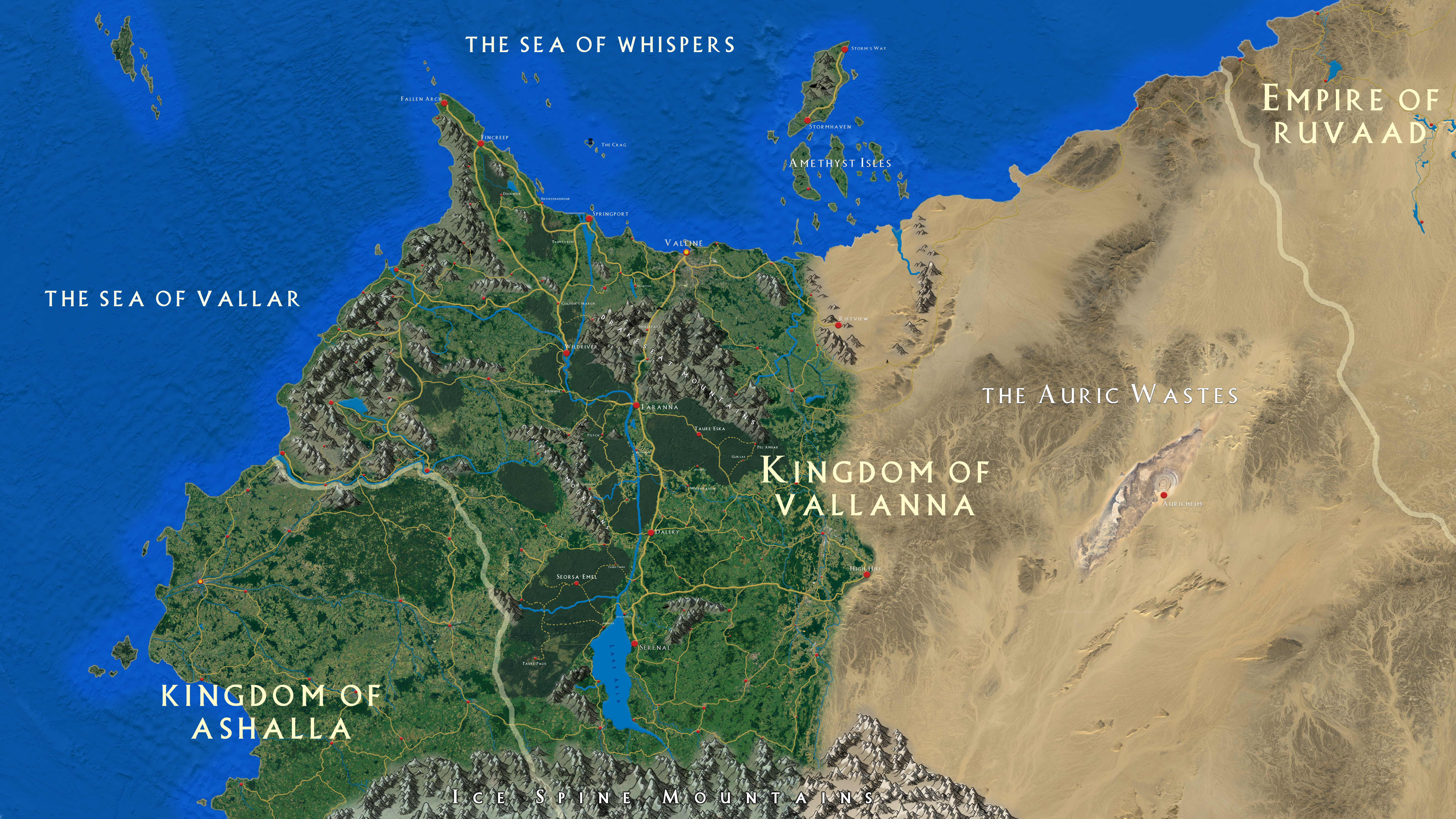
The Land of Vallanna
The land of Vallanna sits on the Northern coast of the continent of Aloris, on the world of Altea.
It is a large nation, ruled over by King Aegic Enarren, and his family.
Aegic rules from the capital city of Valliné, on the northern coastline. His two sons, Walton and Corryn; both Dukes; each rule their own swath of the countryside - Walton from the southern city of Serenal, on the shore of Lake Arla, and Corryn from the city of Laranna, on the banks of the Lifeblood River.
Bordering Vallanna to the South-West is the Kingdom of Ashalla. Vallanna's relations with their smaller neighbour are mostly friendly, finding them a willing trading partner. To the East, across the forbidding Auric Wastes, Vallanna Eastern border adjoins the Empire of Ruvaad. Contact with the Empire is limited, due to the difficulty in crossing the Wastes, but this has also meant that hostility between the two nations has been minimal.
Geography
In the far south, the Ice Spine Mountains mark Vallanna's southernmost border. From these cold peaks, the Lifeblood River falls, first filling the great Lake Arla, before carving its way north, snaking across the countryside, splitting, and finally reaching the sea on both the northern and western coastlines.
The western half of the country is a temperate, vibrant land, with abundant plant and animal life, and many cities, towns and villages which make up the vast majority of the country's population. Dense forests fill large portions of the country.
To the east lie the Auric Wastes, a blasted, hot, dry desert, mostly devoid of life. Vallanna still claim a large amount of the wastes as their territory, although settlements in the wastes are few and far between. Little is known about how the wastes came to be, although many scholars theorise that they were once as green as the rest of the lands, until some unknown magical catastrophe transformed them to what they are today.
Type
Territory
Location under
Included Locations
Included Organizations
Owning Organization


I love the look of your map. What did you use to make it?
It's all done in Photoshop, pretty much. I sketched out the basic outline of the land, and most of the features like rivers and forests and such. Then I took a whole bunch of high-res screenshots using Google Earth of different types of terrain, and stitched them all together to give the satellite image look.
Wow, thats amazing. I have no talent for photoshop. Heck I am struggling to use CC3. Well done. I look forward to seeing more.
Genius idea. Thank you for revealing your style. It looks amazing.