AETHERMARCH
The Roman Provinces · The Empire in the New World · Home
"The provinces are not the Empire's edges. They are its substance. Nova Romae is where we decide things. The provinces are where things actually are."
Aethermarch is the Roman Empire's name for the territory it occupies on the primary continent: ten provinces stretching from the southern coast to the Iron Spine foothills, from the edge of Sylvanmere in the east to the Terminus Magnus frontier wall in the west. It is the largest single political entity on the continent by population, the dominant military power, and the administrative centre through which the known world's commerce flows. It is also, at 1200 A.P., a civilisation in the middle of a succession crisis it has not publicly acknowledged, standing on the eve of a cosmological event it cannot fully prepare for.
Aethermarch was not founded. It arrived. The Eighth Permutatio in Year 1 A.P. transposed a Roman provincial town — eight thousand souls, a Legion garrison, twelve miles of stone roads, and farmland in every direction — from a world that no living Roman remembers into this one. The political system that now governs twenty-two million people across ten provinces began as the administrative structure of a single displaced town, and it has never entirely lost the particular stubbornness of something that survived its first morning against all probability.
Geography
Aethermarch occupies the central band of the primary continent, running roughly northwest to southeast, bounded by natural and political features on every side. The geography shapes the politics with the directness that twelve centuries of administration has not managed to disguise.
To the north, the Iron Spine foothills mark the edge of Provincia Montium Ferri and the beginning of dwarf territory — a boundary that is simultaneously a trading relationship, a military understanding, and the most technically sophisticated diplomatic arrangement Rome maintains. To the northeast, Sylvanmere's treeline defines the eastern limit of Provincia Orientalis: a border that has not been negotiated, only observed, and that has not moved in six hundred years by any mechanism Rome understands. To the west, the Terminus Magnus runs the full length of Provincia Terminus — an eight-hundred-year-old fortified wall that represents Rome's permanent answer to the orc frontier question, which has never been fully answered. To the south, the coast opens onto Mare Profundum and the sea route to Brindala and Solarhet.
The territory's internal geography is dominated by two water systems. The Fluminis Magnus runs north to south through the empire's centre, connecting the Inland Sea to the southern coast in a continuous navigable waterway that carries the bulk of imperial commerce. The Inland Sea itself — approximately 280 km at its longest, irregular in coastline, dotted with islands — is the commercial heart of Aethermarch in the way the Forum Novum is its political heart. Between these water systems, the land is productive, well-settled, and laced with twelve centuries of Roman road.
The transposition zone — the original parcel of terrain that arrived with the Romans in Year 1 — is centred on Nova Romae and extends approximately 100 Roman miles in every direction from the city. Within this zone the land is native Roman in a geological sense that nowhere else in Aethermarch replicates: the soil chemistry, the specific drainage patterns, even the quality of the stone. The farms on this land have been worked since before the Rift. The field boundaries in the innermost ring predate everything else in the empire.
Ecosystem
The Roman provinces occupy a temperate zone broadly consistent across the central band, with gradations that the empire's agricultural economy has learned to exploit efficiently. The river corridors — the Fluminis Magnus and its tributaries — support the richest biological communities, the most productive farmland, and the densest settlement. The Inland Sea's coastal zone has its own maritime ecology, distinct from the river provinces, supporting the fishing industries that supplement the grain surplus. The northern provinces approaching the Iron Spine are cooler, with shorter growing seasons and a transitional ecology between the temperate centre and the mountain biome above.
The original transposition zone maintains a subtle ecological distinction from surrounding territory that the Academy's natural historians have documented but not explained. The crops grown within it tend to higher yield than equivalent soil outside it. Disease resistance in livestock shows statistically significant improvement. The Imperial Agronomists have published three papers on this subject. The College of Pontiffs has suggested an explanation. The Academy finds the explanation unsatisfying but has not produced a better one.
Ecosystem Cycles
The Roman agricultural calendar runs on the four-hundred-day year, with the major cycles calibrated to the temperate central band. First planting occurs in the second month; the southern provinces harvest by the sixth; the northern grain provinces of Septentrionalis complete their main harvest in the seventh and eighth months. The Annona — the imperial grain supply system — coordinates these overlapping cycles into the continuous supply chain that feeds the capital.
The river barge traffic peaks in the eighth and ninth months as the harvest moves south toward Nova Romae and Lacusum. The Fluminis Magnus sees its highest volume during this period; the harbour at Nova Romae handles its peak loads. The maritime season on the Inland Sea runs from the third through the tenth month, with the winter months managed by a reduced schedule of shorter coastal runs. The southern ocean crossing to Brindala operates year-round but is considered significantly safer between the fourth and ninth months.
The military cycle runs parallel: Legion deployments and major frontier operations are scheduled around the agricultural calendar because both depend on the same roads and the same logistical infrastructure. A legion that marches in the eighth month is competing with the grain convoy for road space. This is the kind of administrative tension that the empire has learned to manage without resolving.
Localized Phenomena
Aethermarch has one significant localised phenomenon: the transposition zone boundary, known colloquially in the provinces as the Cicatrix Prima, or First Scar. It is not dramatically visible — you will not see a wall of fire or a shift in the sky. What you will see, if you know what to look for, is a line in the landscape where the geological character changes. The soil colour shifts slightly. The native vegetation transitions over a band approximately three hundred metres wide. Sensitive practitioners — divine casters working near the boundary — report a difference in the quality of divine attention that the College has documented without being able to explain to anyone's full satisfaction.
The boundary runs its full circumference approximately 100 Roman miles from the centre of the Old City district in Nova Romae. Several of the road systems cross it — the Via Militaris passes through it in Provincia Terminus, the Via Orientalis crosses it in the eastern provinces. Most travellers on these roads do not notice the crossing. The farmers who work land on both sides of it have noticed for twelve centuries.
Climate
Aethermarch's climate is temperate throughout the inhabited provinces, with variations by latitude, elevation, and proximity to water that the empire's provincial administration has learned to factor into tax estimates and grain projections with considerable precision.
The river provinces and the capital district enjoy the most moderate conditions: warm summers reaching into the mid-twenties, mild winters rarely producing sustained frost at lower elevations, reliable rainfall in the eighth and ninth months that the farmers structure their planting around. The Inland Sea provinces have a maritime moderating effect — cooler summers, milder winters, and the particular coastal fog of the seventh month that the lighthouse engineers consider their professional nemesis.
The northern provinces are meaningfully harsher. Provincia Septentrionalis sees harder winters than the capital; Provincia Montium Ferri, in the Iron Spine approaches, has winters that close the mountain passes for approximately three months and that the population manages with the practical efficiency of people who have never known anything easier. The southern provinces — Australis, Campi — are the warmest, with the coastal province experiencing the most extended warm season in the empire.
The western frontier province, Terminus, has a climate shaped as much by its cultural exposure as its latitude: the prevailing winds off the orc territories carry nothing that meteorology can measure, but the frontier soldiers who stand watch on the wall have opinions about what autumn feels like in Provincia Terminus that their counterparts in the capital would find melodramatic.
Fauna & Flora
The Roman provinces support the most thoroughly documented flora and fauna on the primary continent, a consequence of twelve centuries of agricultural management, Academy scholarship, and the particular Roman tendency to name and catalogue things. The cultivated species are well-established: the grain varieties of Septentrionalis, the olive groves of Australis, the island wine-grape cultivars of Provincia Insularis that have been selected and improved across forty generations of vintners.
The wild margins — the uncultivated edges of the river valleys, the woodland patches between farmed land, the coastal wetlands of the Inland Sea's irregular shoreline — retain native species that the Academy has documented in the Catalogus Naturalis, now in its twelfth edition. Large fauna in the interior provinces is primarily managed woodland deer and the river otters that the bargemasters consider good luck. The coast supports marine life that the fishing industry has catalogued with the attentiveness of people whose income depends on understanding it.
The northern frontier zone, approaching the Iron Spine, has species that are transitional between the temperate provinces and the mountain ecology: hardy upland grasses, stands of conifer that become denser and taller as the foothills rise. The eastern frontier, approaching Sylvanmere, presents a different problem entirely: the native woodland of Provincia Orientalis transitions, at the treeline, into something that the Academy's naturalists have not been able to classify because they cannot enter it. What grows within Sylvanmere is not available for study.
Natural Resources
The Road Network
The Roman road network is the empire's primary strategic asset and the mechanism by which a territory spanning ten provinces functions as a single administrative unit. Approximately 45,000 kilometres of paved stone road connect every significant settlement in Aethermarch. The major arterials — the Via Militaris to the western frontier, the Via Orientalis to the east, the Via Lacensis to the Inland Sea, the Via Australis to the southern coast, the Via Septentrionalis to the northern provinces — are maintained by the Officium Viarum to military standard. Travel times on these routes are reliable, waystations are spaced for a day's march, and military escort is available at Legion posting-stations.
The road network was the primary instrument of Roman expansion in the first three centuries and remains the primary instrument of Roman administration today. A governor who controls his roads controls his province. The Senate understands this. So does every provincial governor who has ever sent a dispatch.
Agricultural and Trade Resources
| Province | Primary Resource | Secondary Resources |
|---|---|---|
| Provincia Urbis | Mixed agriculture (oldest cultivated land) | Administrative services, sacred sites |
| Provincia Fluminis Magni | River transport, mixed farming | Timber, river-fish, barge construction |
| Provincia Lacus Interioris | Trade and commerce, fishing | Maritime services, insurance, finance |
| Provincia Insularis | Wine (Vinum Insulare), lighthouse services | Fishing, navigation expertise |
| Provincia Septentrionalis | Grain (imperial surplus) | Livestock, limestone, cave systems |
| Provincia Montium Ferri | Metals, mining, dwarf-trade goods | Timber, stone quarrying |
| Provincia Orientalis | Mixed agriculture, timber | Academic research (forest-edge studies) |
| Provincia Terminus | Military production, frontier trade | Timber, quarried stone, orc-trade goods |
| Provincia Australis | Southern trade goods, maritime | Fishing, salt, Brindala transit commerce |
| Provincia Campi | Mixed agriculture, livestock | Centaur-trade horses and leather |
History
The Romans did not choose to be in Aethermarch. The Eighth Permutatio chose for them. On the morning of Year 1 A.P., a Roman provincial town — eight thousand souls, the XIV Gemina Legion, and everything within approximately one hundred Roman miles — was transposed from the old world into this one. The governor's surviving dispatch from that morning reads, in its entirety: "The stars are wrong. The road ends. We are sufficient unto ourselves. We will manage." They managed.
The first century was survival and consolidation. The Legion surveyed the boundaries of the transposition zone, established contact with the dwarves through geometry (the first diplomatic exchange conducted in mathematics on either side), and began the expansion that would, within two centuries, produce the outlines of the empire that exists in 1200 A.P. The constitutional transition from provincial governance to imperial rule occurred in 203 A.P. when Governor Quintus Romanus Maximus declared himself Emperor; the Senate ratified the declaration after forty-seven days of debate, establishing the precedent that has governed every succession since.
The twelve centuries that followed are chronicled in the Annales Mundi. The markers of Aethermarch's history that have shaped its current geography are: the establishment of the Terminus Magnus (~380 A.P.), which fixed the western frontier; the Grey Plague of 500 A.P., which reduced the population by fifteen to twenty percent and whose long shadow still falls on Roman medical policy; the centaur alliance, formalised after the Battle of Mons Conspectus in 225 A.P.; the deepening of the dwarf engineering partnership from the third century onward; and the halfling arrival in 1000 A.P., which introduced the maritime trade network that now makes Aethermarch's luxury economy possible.
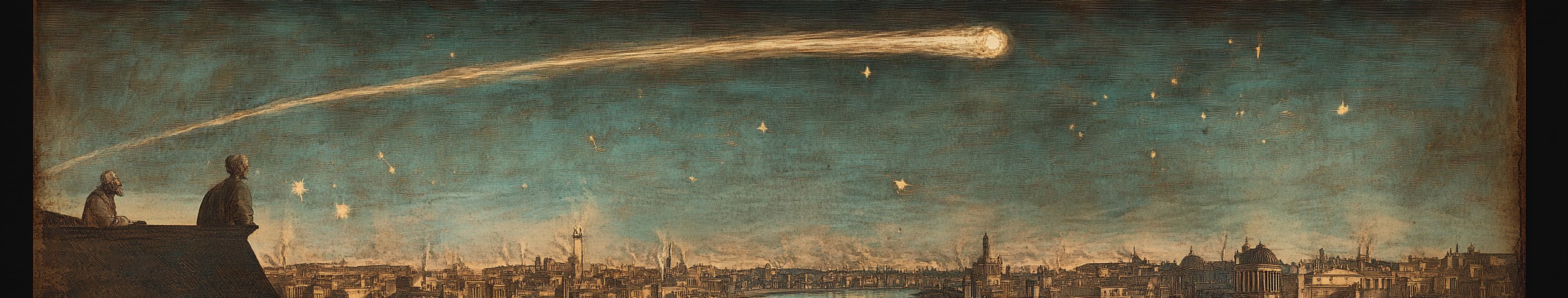
In 1200 A.P., Emperor Gaius Aurelius Maximus has ruled for a century — the longest reign in Aethermarch's history. The succession question hangs over the Senate. The Pale Wanderer is in the sky.
For the full chronological account, see: Annales Mundi — A Complete Chronology of the Rifted World.
Tourism
Aethermarch is the most visited territory on the primary continent, by a significant margin, for the straightforward reason that it is the only major territory that non-Roman visitors can enter without an invitation that takes years to obtain. The imperial road system, the waystations, the commercial hospitality infrastructure of a twenty-two-million-person economy — all of this exists and all of it is accessible to anyone with legal status or a trading relationship.
Nova Romae draws visitors for reasons ranging from pilgrimage to the Capitoline temples, to commercial negotiation in the Senate Quarter, to the cultural spectacle of the largest city in the known world. Lacusum draws merchants. The Iron Spine surface trading posts draw anyone with goods that dwarves want. The frontier provinces draw a specific category of visitor who wants to stand on the Terminus Magnus and look west — scholars, military theorists, and the occasional person who has read one too many accounts of orc raids and wants to understand what they actually mean.
The halfling community maintains commercial hospitality establishments in every significant settlement in the empire. Their guest-houses are more comfortable than Roman equivalents at the same price point and their intelligence about local conditions is better. Both facts are well understood by experienced travellers.

Comments