CONTINENS PRINCIPALIS
The Primary Continent · The World Shared by Many · The Stage of the Known Age
"The world is not nine separate territories inhabited by nine separate peoples. It is one world, shared by everyone in it, organised by the Permutatio into the specific configuration of peoples and territories that we now inhabit. Every border is the product of events — political, military, geographical, cosmological — that connect to every other border."
The primary continent is the largest landmass in the known world and home to seven of the nine civilisations that comprise the rifted world's inhabited population. It is bounded by ocean on all sides, though the northern seas give way to an arctic archipelago that the giants have made their own, and the eastern horizon conceals a second continent that no expedition from this shore has successfully reached and returned from. To the south, across Mare Profundum, lies the southern continent where the tabaxi maintain their city-state of Solarhet; to the southwest the Archipelagus Brindala serves as home and commercial hub for the halfling Merchant Council.
The continent has no single governing authority, no common language, and no unified history prior to the Permutatio system that deposited its peoples here over the course of fourteen hundred years. What it has, in place of unity, is proximity — and proximity, in the fullness of centuries, has produced the complex web of alliances, enmities, trade dependencies, and mutual incomprehensions that constitute the political world of 1200 A.P.
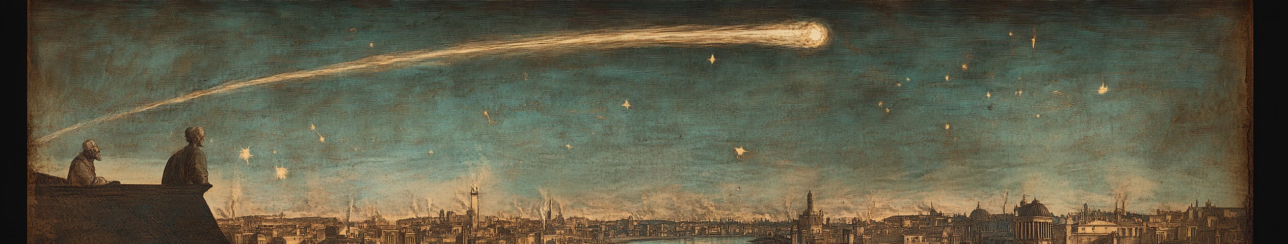
The Pale Wanderer is currently visible in the night sky, growing brighter each month. Every civilisation on this continent knows what that means.
Geography
The primary continent is irregular in form, wider at the centre than at its northern and southern extremities, and the product of geological processes that do not entirely respect the Permutatio system that overlaid its current inhabitants upon it. The underlying terrain — the mountains, rivers, and coastal features that existed before the first people arrived — is native to this world. The peoples are not. Understanding which features are original and which were transposed with arriving civilisations is one of the more intellectually demanding questions in Aethermarch geography, and one I have spent considerable effort addressing.
The Central Spine. The Iron Spine — Mons Ferrum in the Roman cartographic tradition — runs roughly east to west across the northern interior, forming the continent's most prominent elevated feature. These are not young mountains: their edges are worn, their passes known and navigable to those with proper guidance, their character more monumental than aggressive. They rise to three thousand metres at the central massifs and are permanently snowcapped above two thousand. Below them, the dwarven holds extend downward through twelve hundred years of excavation into a subterranean civilisation whose extent no surface map adequately captures. The Iron Spine is as much a political fact as a geographical one: it marks the northern limit of Roman expansion and the surface boundary of the most technically sophisticated civilisation on the continent.
The Western Territories. West of the Roman frontier and north of the southern plains lies the largest uninterrupted land territory on the continent: the Wildlands, Terrae Ferae, where the Grakh'tor have maintained dominance for a thousand years. The terrain here is varied in ways that Roman writing tends to obscure — the western volcanic coast, with its basalt plains and the sacred Caldera of Grakh'vol, is utterly unlike the mixed forest and grassland of the central and eastern reaches, which are themselves distinct from the dense dark-timber forests of the northwest interior. The continent's western coast presents a long, rocky shoreline that has not invited sustained maritime development from its inhabitants.
The Central-Southern Corridor. The Roman provinces occupy the central band of the continent, running roughly east to west: from the Sylvanmere forest's edge in the northeast, through the agricultural heartland north of the Inland Sea, down the Fluminis Magnus river corridor to the southern coast. This corridor is the continent's most densely inhabited and most thoroughly mapped territory. The Inland Sea — an irregular body of water approximately 280 km at its longest — sits at the corridor's commercial centre, receiving the productive surplus of eight provinces and redistributing it through Lacusum to the known world. The Fluminis Magnus, running north to south from the Inland Sea to the southern coast, is the single most important piece of infrastructure on the continent: the spine along which imperial commerce moves.
The Southern Plains. South of the Roman frontier and west of the Provincia Campi border, the Campus Magnus — the Great Plains — extends across the continent's southern reaches from the Montes Dividentes in the southwest to the eastern sea. The centaur Hava'keth have inhabited this territory for a thousand years and know it with a precision that Roman cartography has not matched. The Montes Dividentes — the Dividing Mountains, or Keth'havar in centaur — cross the southern continent east to west, old and rounded ranges whose passes are all named and all known to the people who have used them for a millennium. From these mountains rivers descend in every direction, defining the plains' character as much as the grassland itself.
The Northeastern Forest. In the northeast, Sylvanmere occupies a territory that Roman cartographers have mapped only at its edges. The forest is closed. The treeline, where it meets Provincia Orientalis, is the continent's most unusual border: not a wall, not a watercourse, not a surveyed line, but a point at which the landscape becomes something other than landscape. Six centuries of Roman habitation at the forest's edge has produced a precise record of where the treeline stands and a complete absence of reliable information about what lies beyond it. The elves do not provide tours.
The Far North. Above the Iron Spine, the continent's northern reaches transition through taiga to arctic territory before meeting the northern sea. The Joturvolk — the giants — maintain a mainland presence in the taiga belt and a primary homeland in the northern archipelago beyond. This territory is cold, sparsely inhabited, and known to the rest of the continent primarily through dwarf-giant working arrangements at the mountain passes and the oral sagas that halfling traders have occasionally been permitted to hear.
Ecosystem
The continent's ecosystems are broadly stratified by latitude and altitude, but this description conceals the more interesting observation: that the Permutatio system has deposited, at twelve discrete sites across the continent, parcels of terrain from other worlds. These Rift zones are not native to this continent. Their flora, their soil chemistry, their atmospheric quality — where it has been possible to measure — do not match their surroundings. They are, in the most literal sense possible, foreign bodies embedded in a landscape that has spent centuries trying to integrate them.
The native ecosystem of the continent's central and southern reaches is temperate grassland and deciduous woodland, grading to coniferous forest in the northern highlands and tundra above the Iron Spine's northern face. The river valleys support the richest biological communities — the corridors along the Fluminis Magnus and the Campus Magnus rivers are among the most productive agricultural environments in the known world, which is why the Romans chose them and why the centaurs have worked them for a thousand years.
The Rift zones interrupt this pattern in ways that are specific to each arrival. The area around the Grakh'vol Fen retains vegetation of a species found nowhere else on the continent; the soil in the transposition zone has a chemical composition that native plants struggle to colonise. The forest of Sylvanmere, whatever its relationship to the original elvish homeland, operates as an ecological system of unusual coherence — the forest does not merely grow at its edges, it maintains its edges, and the treeline is not the product of gradual succession but of something more deliberate. The centaur Rift Valley at Keth'halvara, where the Ninth Permutatio opened, remains geologically anomalous in its eastern mountain context.
I note, for the record, that the continent's native megafauna is less well documented than its political geography. Scholars interested in the fauna of the Wildlands interior or the Sylvanmere forest edges will find that the sources thin rapidly beyond what direct Roman observation provides, and I do not propose to supplement observation with speculation.
Ecosystem Cycles
The continent's seasonal rhythms vary considerably by territory and are experienced differently by each people who inhabits them.
The Roman provinces operate on the four-hundred-day calendar, with agricultural cycles calibrated to the temperate central band's warm summers and mild winters. Harvest in the river provinces typically runs across the seventh month; the northern grain provinces of Septentrionalis run a month later. The Annona — the imperial grain supply system — coordinates these cycles into the supply chain that feeds Nova Romae's eight hundred thousand.
The Campus Magnus has no single seasonal cycle. The centaur tribes' annual migrations follow the grassland's rhythms across three distinct climate zones — the eastern plains' predictable pattern, the southern coast's more variable weather, the western ranges' harder seasons — and the shamanic tradition maps these cycles with a precision that Roman scholarship has not replicated. The great inter-clan moot at Keth'halvara convenes at the same point in the year, every year, calibrated to astronomical observation that the centaur elders have maintained for a thousand years.
In the far north, the Joturvolk organise their seasons around the arctic pattern: a brutal winter during which the northern archipelago's sea lanes close, a short intense summer during which the hunting and fishing that sustains the population must accomplish what the rest of the year cannot. The pack ice at the northern reaches sets in by the ninth month and does not reliably clear until the third.
The dwarven holds observe no seasons in any meaningful surface sense, being underground. Their agricultural cycles are artificial — the farming levels operate under gas-lit conditions calibrated to support crop growth independent of surface conditions. I address this in the Iron Spine article.
Localized Phenomena
The continent has twelve known Rift zones — the physical sites where the Permutatio events opened and through which arriving peoples were transposed. Each retains some degree of anomalous character. The oldest, at Sylvanmere, has had fourteen hundred years to integrate with its surroundings and has instead become the forest that contains it. The most recent, at the Archipelagus Borealis where the giant homeland anchors the northern sea, is less than five hundred years old and still geologically restless in ways the halfling maritime pilots have learned to chart.
The Grakh'vol Fen warrants specific mention. The area around the Third Permutatio site exhibits persistent anomalous light — a reddish quality present at midday as at dusk, noted independently by every observer who has reached sufficient proximity. The vegetation within the rift boundary is alien to this world and has shown no tendency to naturalise in a thousand years. The orc shamanic orders maintain a presence at the boundary. No Roman observer has entered the site and produced a subsequent report.
The continent's single most significant unresolved geographical anomaly is not a Rift zone but a waterway: the Inland Sea contains, in its northeastern quadrant, a record made in Year 412 by the senior engineer of the Pharus Magnus lighthouse describing an observed form of a size inconsistent with any known marine creature. The record is professionally restrained. No subsequent record from this period references anything in the same waters. The guild does not advertise the entry's existence. I include it here because I have read it and because I believe that accurate geography requires noting what one cannot explain, not only what one can.
The Pale Wanderer itself is, in the current year of 1200 A.P., visible to the naked eye every clear night and growing measurably brighter. The continent's peoples have each developed interpretive frameworks for this phenomenon. The Roman College of Pontiffs has issued theological guidance. The centaur shamans have altered their listening posture toward the northern wind. The dwarven orrery at Thalgrimm has produced a calculation whose results the High Thane has not shared. What is shared across the continent, whether acknowledged or not, is the understanding that the sky is changing and that the last twelve times the sky changed in this manner, a people arrived from elsewhere and the world reorganised itself around them.
Climate
The continent spans sufficient latitudinal range to encompass arctic conditions in the far north, temperate maritime and continental climates through the middle bands, and a warm southern coast that produces the empire's finest wine and most eager mariners.
The Roman provinces experience a temperate climate that favours the agriculture their economy depends on: warm summers, mild winters, reliable rainfall in the eighth and ninth months of the year. The interior provinces are drier than the coastal ones; the mountain approaches of Provincia Montium Ferri are colder and longer in winter than anything in the river corridor. The southern coast of Provincia Australis is warmest of all, with a maritime character shaped by the sea routes that make it Aethermarch's southern window.
The western territories receive the prevailing ocean winds off the continent's western coast, making the volcanic coastal zone of Terrae Ferae wet and wind-scoured, the interior a more continental pattern of hot summers and hard winters. The northern taiga beyond the Iron Spine is cold throughout the year by Roman standards, and the arctic territory of the Joturvolk is beyond the reach of Roman weather reporting to characterise accurately.
The Campus Magnus has three distinct climate zones corresponding to its eastern, southern, and western ranges — a diversity that the centaur shamans have mapped over a thousand years of attention and that Roman cartographers have only partially captured. The eastern plains are mildest; the southern coast-influenced zones more variable; the western coastal ranges roughest, with weather that does not invite extended settlement by those not born to it.
Fauna & Flora
The continent's native flora and fauna are temperate in the central and southern zones, hardening to boreal and arctic species in the north. The river valleys support the most diverse native communities — the Fluminis Magnus corridor has been farmed for twelve centuries, but the uncultivated margins retain stands of native woodland that have been documented by the Imperial Academy's natural historians.
The Rift zones are the most botanically significant exception to any general characterisation of the continent's flora. The Grakh'vol Fen contains plant species that correspond to no native genus — woody, thorny, growing in forms that suggest adaptation to conditions this world does not produce. Samples collected at the zone's boundary and submitted to the Academy have resisted classification for sixty years. The elf forest presents a different order of problem: the treeline vegetation is continuous with the native species of Provincia Orientalis, but the internal ecosystem of Sylvanmere — whatever it is — has not been available for study.
Large fauna in the unclosed territories are consistent with what one would expect of a temperate continent: game animals in the woodland zones, grazing herds on the plains, marine life in the Inland Sea and the coastal waters. The northern seas support the hunting that the Joturvolk depend on. I note with appropriate scholarly caution that reports from the Campus Magnus's western coastal ranges describe fauna that the eastern-range centaurs do not recognise — whether these are native species, Rift-transposed species, or the product of a thousand years of isolation in the far western territories, I cannot determine from available sources.
Natural Resources
The Road Network and Continental Connectivity
The Roman road network is the finest overland route system in the known world: paved stone roads, maintained waystations every thirty kilometres, military escort available on the major arterials. The Via Militaris runs west to the Terminus Magnus frontier; the Via Orientalis runs east to the Sylvanmere border; the Via Lacensis connects the capital to the Inland Sea. These roads knit the ten Roman provinces into a single administrative and commercial unit.
Beyond Roman territory, connectivity degrades sharply. The orc frontier is crossed at specific border market points under protocols maintained by both sides — practical and regularised, but not welcoming to those without established trading relationships. The dwarven surface trading posts operate on their own schedule at the three inhabited pass mouths. Sylvanmere presents no road and no crossing. The Campus Magnus has no roads in the Roman sense — the centaur tribes know every seasonal route and water source across its extent, but this knowledge is not published in a form that Roman surveyors can work with.
The Fluminis Magnus and the Inland Sea constitute the continent's primary maritime corridor — a continuous navigable waterway from the southern coast to the empire's commercial heartland that is, in terms of goods-volume moved, the most significant single route in the known world.
Primary Resources by Territory
The Roman provinces produce grain in surplus — Provincia Septentrionalis alone feeds significant portions of the capital — as well as timber, livestock, stone, and the metalwork that the dwarf engineering partnership has enabled at a scale impossible otherwise. The Iron Spine produces metals and engineering output that Rome cannot replicate independently. The Campus Magnus yields horses and leather, both structurally important to Roman military and commercial operations. The orc and goblin territories produce resources that enter the Roman economy only through the border markets and at prices that reflect the difficulty of the supply chain. Sylvanmere produces nothing that reaches the outside world by any channel that I have been able to document.
History
The primary continent has been inhabited, in one configuration or another, for at least fourteen hundred years by the reckoning of the A.P. calendar. Before the elvish arrival at Rift I, its history is known only through what the continent itself recorded — in geological strata, in the native flora that preceded all arrivals, in what the elves found when they got here, which they have not, in the main, discussed.
The successive Permutatio arrivals have been documented in the Annales Mundi; readers seeking the full chronological account are referred there. What the geographical record establishes is that each arrival changed the continent physically as well as politically. The orc territories bear the mark of a thousand years of clan governance in their deforested highland ridges and managed grazing lands. The Roman provinces bear the mark of twelve centuries of engineering in their road network, their drained wetlands, their walled cities. The dwarven Iron Spine bears, below the surface, the mark of the most extensive sustained excavation project on the continent.
The continent's current political geography traces, at every border, to one of three sources: the outcome of the Bellum Magnum (-900 A.P.), which established the Iron Spine, Sylvanmere, and the western plains as fixed territorial limits; the arrival of the Romans and their subsequent expansion against the existing distribution; or the diplomacy and conflict of the intervening twelve centuries that adjusted those lines at the margins without revising them fundamentally. No border on this continent has moved significantly in three hundred years. The Rift will move them.
For full timeline, see: Annales Mundi — A Complete Chronology of the Rifted World.
Tourism
The Peoples of the Continent
Seven civilisations currently inhabit the primary continent. Each is addressed in full in its own regional article; the following is a summary for orientation.
| People | Territory | Rift | Population (1200 A.P.) |
|---|---|---|---|
| Romans (Romani) | Central provinces — Aethermarch | VIII · 1 A.P. | ~22 million |
| Dwarves (Khazadûm) | The Iron Spine — Spina Ferri Magna | II · -1200 A.P. | ~2.2 million |
| Elves (Ael'sethana) | The northeastern forest — Sylvanmere | I · -1400 A.P. | ~180,000 (declining) |
| Orcs (Grakh'tor) | Western territories — Terrae Ferae | III · -1000 A.P. | ~8 million |
| Goblins (Zrek'vali) | Beneath the orc territories — the Deep Warrens | V · -600 A.P. | ~14 million |
| Centaurs (Hava'keth) | The southern plains — Campus Magnus | IX · 200 A.P. | ~1.8 million |
| Giants (Joturvolk) | The far north and northern archipelago — Jotunfjell | IV · -800 A.P. | ~120,000 |
The total inhabited population of the primary continent, across all seven peoples, is approximately 48 million by my best estimate — a figure I hold with the uncertainty appropriate to a calculation that relies, for the dwarven underground and goblin warren populations, on inference rather than census.
On Travel Across the Continent
The continent is not freely traversable. Roman territory — the ten provinces, the road network, the Inland Sea corridor — is open to those with legal status or a trading relationship. The orc frontier may be crossed at the designated border markets. Everything else requires either invitation, established relationship, or the particular category of personal credibility that takes decades to build and cannot be purchased.
I note this not as complaint but as geographical fact. The continent's political divisions are, for most travellers, its most significant physical feature.

Comments