Malplenan
Political
There are 14 nations on Malplenan, and two distinct regions with an ever changing number of tribes. These nations are largely grouped into four categories:Geography
Malplenan is divided in two by a long stretch of mountains that span from the north west tip all the way down to the middle of the southern shore. The two halves are often referred to as "north of the mountains" and "south of the mountains". However, the western portion of the mountains start to blur the line between what is in the mountains and what is south of the mountains.
Kaveto Mountain stands in the center of the continent, towering above all of the other mountains. It is strangly warm high up the mountain, and Zapryesh starts to take effect. Many of the world's oldest artifacts are found around the mountain as well.
The mountains are made up of five chains, from west to east, the Wanta Mountains, Rodante Mountains, T̍lim̍ Qul Mountains, Settentrionale Mountains, and the Meridionale Mountains. There are four main ways to get through the mountains, The Pass, Kaveto Pass, Pallina Pass, and across the Trucco Peninsula. The Wanta Mountains, especially its ridge, are considered impassible.
The geography south of the mountain is varied. There is the Rodante Hills , which is a drier climate, the Amikwànò Marshlands which collect all of the moisture, the Kaveto Plateau, which is heavily forested with coniferous trees, and the Khünd Plains.
North of the mountain is a lot more homogenous. The majority of the land is taken up by the deciduous forests of Chaa Mui Forest, Baissart Forest and Guhkki Viesut. However, there are a couple small regions of the Kaveto Foothills and the Boneana Lowlands.
The last region is known as the Wanta Desert. It is locked between the Wanta Ridge and Umi Cliffs. Our only knowledge of that area comes from the world map, which was created by flying over the mountains with a sketchpad. Passage in and out of the region is extremely dangerous and no known species live there.
Maps
-

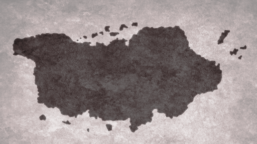
World Map
Type
Continent
Included Locations
Inhabiting Species

Comments