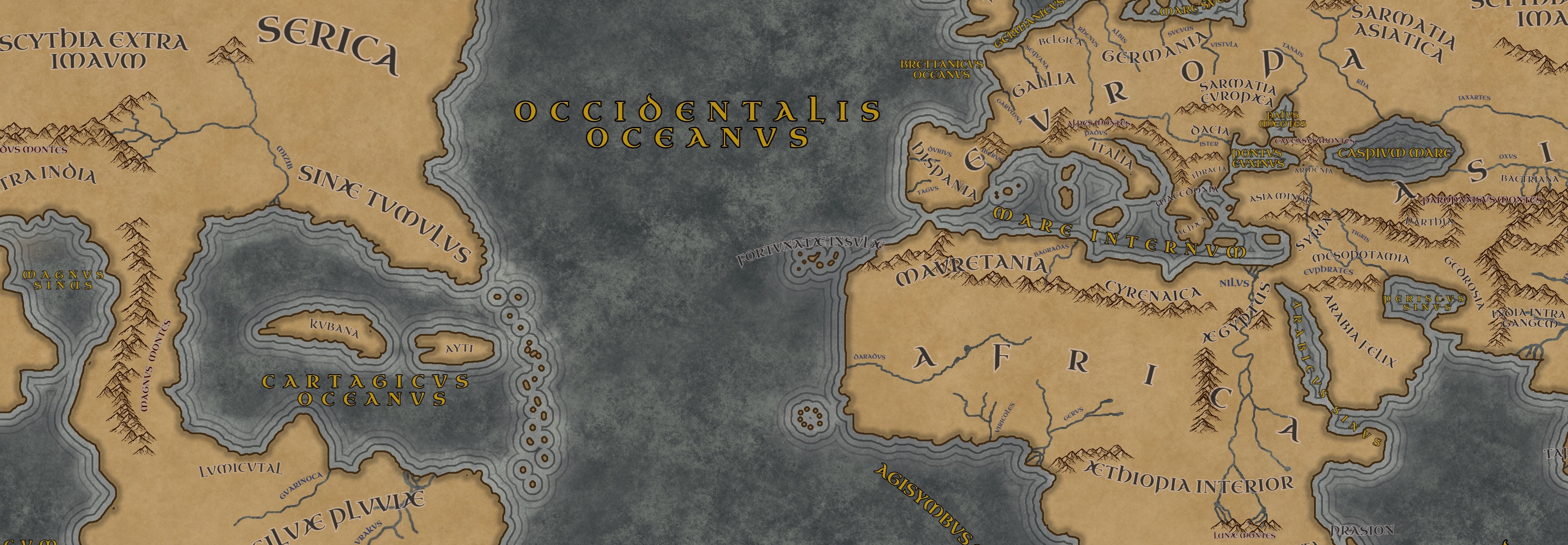
The Worldmap
As the centuries went by the knowledge of the world itself grew. With the discovery of the Terra Occidentalis by the Romans their view of the world changed. Because of this a new world map was created incorporating all the new knowledge of the west and the knowledge of the Greeks to the east.
The account below is written by the Roman Geographer Marcellus of Massalia
The mighty city of Rome has a long history of conquest and expansion. In the current era it is perhaps fair to say that no nation in the world reaches as far as us. With our growing number of colonies across the Oceanus Occidentalis we are at a point that we might even surpass Alexander's empire. The further we expanded and traded the more we learned about the world. Thanks to the combined efforts of the Greek scholars to the east and our explorers we know vastly more about the world than we did in the past.
For a long time the world outside the Mare Internum was not known. This changed with the conquests of Alexander the Great as new information of far away regions became known. The Greek Scholar Eratosthenes of Cyrene included these finding in his studies and created a map of the world. He calculated the circumference of the world to be
252,000 stadia . A different calculation was later done by Poseidonius of Apameia of which the results are to this day still up for debate. Some claim it was close to Eratosthenes' calculation with
240,000 stadia while others, such as myself, know the correct calculation is
180,000 stadia. This calculation uses a correction of the distance between Rhodes and Alexandria to 3,750 stadia. It is on these calculations that I based my world map.
Notes: The circumference used by Marcellus is of course incorrect. The calculation used by Eratosthenes was much closer to the correct value but was sadly not accepted by all. The result of this was that during the Middle Ages many believed the world to be much smaller than it really was. It is because of this smaller circumference that Colombus believed that it was much easier to sail around the world.
In the world of Terra Occidentalis this calculation results in the Romans assuming that the continent to the west is linked to Sinae/Serica (China).
Continents
Europa
Europa is in current times the name most commonly used for the continent on which the mighty city of Rome and Italia are located. We Romans derived the use of this name from the Greeks who first came with the idea of dividing the world into three different parts Europa, Asia and Libya. Today we still refer to everything from western Iberia to the Pontus Euxinus as Europa.
Whereas the Greeks to the east mostly conquered the lands of Asia the Romans mainly expanded on the European continent. It is home to vastly different areas such as our beautiful Italia, the magnificent Alpes Montes, the fertile lands of Gallia and Belgica , the large island of Albion and the never ending forests of Germania . All of these lands now belong to Rome.
However, there are still areas outside of Rome's reach such as the cold and rugged lands of Scandia and Hyperborea , the plains of Sarmatia and the lands controlled by the Greeks to the east.
Countries
Rome occupies most of western Europa after centuries of conquests. Due to a strong presence of the Alexandrian Empire to the east during Rome's early conquests, Rome mainly focussed on western and northern expansion. Even when the Alexandrian Empire eventually split after the death of Alexander VI, the most western Greek succesor state was still too powerful to oppose. In Europa Rome currently controls Iberia, Gallia, Belgica, all of Albion, part of Scandia and a large part of Germania up to the Suevus river.
A large part of eastern Europa is controlled by the Macedonian Empire, one of the Alexandrian Empire's succesor nations. Their territories encompass a large part of the Balkan including Dacia, Thracia and part of Illyria. In addition to these lands the Macedonians also control all lands around the Pontus Euxinus and most of Asia Minor
The areas not claimed by these two nations remain independent for now. This includes Sarmatia Europae, the tribes of Hyperborea and Hibernia .
Asia Orientalis
Our knowledge of Asia greatly increased after the conquests of Alexander the Great. With each new expansion of his empire and that of his successors, new lands became known to us. We now know that the continent is vast, much larger in size than Alexander himself anticipated.
The most well known regions of this continent are those around
Mesopotamia . Due to its large rivers the Euphrates and Tigris this region is hospitable despite the warm climate. This is in stark contrast to
Arabia to the south which mostly consists of arid deserts except for the more fertile
Arabia Felix. It is therefore no wonder that the center of this region remains unclaimed by the larger nations around it.
Further east one can follow the large mountain ranges all the way to India where they become the
Emodus Montes . According to various reports this mountain range is enormous with mountains reaching far above the clouds. From these mountains many great rivers flow into India which provide these lands with abundant water. Strange humid forests can be found here not so different from the
Silvae Pluviae in the
Terra Occidentalis .
Asia Occidentalis
Asia is divided into two parts by the Imaus Montes , a long mountain range starting from the Emodus Montes towards the north. To the east of these mountains there are lands that remain mysterious to this day. However, when we heard of the lands to the west settled by the Punics, some light was shed on this part of the world.
As it is easiest for us to reach it by sailing west we commonly refer to all lands on the other side of the Imaus Montes as Asia Occidentalis. The northern part of this continent remains unknown but we do know that further south we can find the Scythian lands on the other side of the Imaus Montes and Serica , the land of silk. Although higly coveted, silk is not known to the tribes on the eastern shores of the continent.
Further south from Serica one can find the Sinae people. The region closer to India has become known as Sinae Extra India and has a similar climate. No Romans have visited these lands which is why not much is known about them. On the other side of the continent the Sinae Tumulus lands are more frequently visited by the Punics. From their accounts we know that there is a great variety among them with some living in tribes while others have larger settlements. Their buildings are often on large mounds after which the region is named. The climate of the region is hospitable and a large river known as the Mizib is known to travel through a large part of these lands. The coastline of these lands is based on notes from Punics as no Roman expeditions have been undertaken there yet.
Countries Asia
Most knowledge of Asia came to the Romans through the Alexandrian Empire and its successor nations. This empire stretched from Macedonia to India even long after the death of Alexander. Eventually a civil war after the death of Alexander VI saw these lands devided. The Macedonian Empire is the most western of these nations and contains Dacia, Thracia, Asia Minor and part of Illyria but also later conquests around the Pontus Euxinus.
The largest of these successor nations is by far the Greco-Persian Kingdom which stretches from Syria to the edge of India and far into the plains to the north as well. The other Greek nation of Asia is the Indo-Greek Kingdom which covers most of India with the exception of the southern Tamil kings. The people living beyond the Ganges are mostly unknown to the Romans and are commonly referred to as the Sinae.
What the Romans view as Asia Occidentalis is mostly an incorrect combination of both eastern Asia and North America. This is mainly due to the incorrect calculations used for the circumference of the world. Where they place the Sinae Extra India peninsula is in reality the Indochina peninsula which is controlled by various nations such as the Mon and the Khmer and partially also the Chinese Han Dynasty. In the north the area that the Romans refer to as Scythia is under the control of the Xionghu Khanate which could possibly have partially been inhabitated by Scythians/Iranian people.
Countries North America
The area the Romans refer to as Sinae Tumulus is in reality the southern edges of north america near the Gulf of Mexico. This is drawn completely out of proportion since the information of these lands came to the Romans indirectly through trade with the Carthaginians. The coastal areas are already heavily settled by the Carthaginians by the time the Romans came to the new world. Trade between the Carthaginians and the Native Americans has been common for a long time and many natives eventually joined the Carthaginian settlements.
Further inland there are various cultures that are mostly unknown to the Romans. They believe there are two main groups, the people of the Sinae Tumulus and the eastern Serica cultures. The Sinae Tumulus people, named after their settlements with mounds, correspond with the Hopewell cultures. The eastern Serica cultures are of course not at the edge of China but also Native American cultures.
Terra Occidentalis
For a long time we thought that the Punic nations were gone. However, when we encountered them at the
Fortunatae Insulae the exitence of this mysterious continent became known to us. Through years of hard work and many losses we finally managed to make the trip across the vast ocean and reach the
Tera Occidentalis. Over the years that followed we explored and build colonies along the southern shores of the continent but this is only the beginning. I forsee a great future for the Romans in these new lands.
Most of the Terra Occidentalis remains unknown but a good portion of the shorelines has already been explored by our
Cohors Exploratorius. The continent's most notable feature is of course the
Silvae Pluviae, this gigantic forest with towering trees and exotic fauna and flora is a true sight to behold. Through this magnificent forest flows the
Naurakus, a large river that goes deep into the continent and that has only been partially explored.
Following the coastline to the south-west leads to a dryer environment with large grasslands furhter inland where many of the first Roman settlements were built. Further south another large forest hugs the coastline but how far south it goes is still unknown. As of this date no explorations have been done much further than the
Colonia Australis.
To the north there is the
Carthagicus Oceanus in which many islands can be found. Maps for this region are difficult to create as no large scale exploration has been done by Romans here. Most of our knowledge of the region comes therefore from the Punics who call the area their homeland. The largest island in the region, Kubana, is home to their capital. But also the penisula of Lumicutal has a Punic presence, although the inland regions remain under the control of the Mayab people.
Countries
The Terra Occidentalis corresponds to the South American continent. Because the Romans used incorrect calculations for the circumference of the world they believe te continent is linked to Asia. Most of the Roman current settlements in the region are located in current day Brasil but are mostly located on the coast. Further inland there are various tribes that the Romans refer to as Ava people. In reality this is not a one group but rather a combination of proto Tupi and Ge cultures. Further north near the Orinico river there are a few carthaginian settlements but most areas remain in the hands of the Lokono people.
The islands of the Caribbean are heavily settled by the Carthagians after the many centuries that passed since they first set foot here. Further west there are less Carthaginian settlements but there the coastal areas of the Gulf of Mexico do have a strong Carthaginian presence still. The primary trade partner of this region are the Mayab people of the Yucatan peninsula.
Africa
Geography
Just across the Mare Internum the continent of Africa can be found, a region rich in history. In contrast to southern Europa, the north of Africa has a rather hostile climate. A large desert spans most of the northern continent which is why the deeper areas of the region are not heavily inhabited. Most settlements are near the coast or next to large rivers such has the Nilus.
It was not until Romans sailed to the Fortunatae Insulae along the west coast of Africa that we decided to explore further south. From the islands the coastline goes further south until it start to bend eastwards. In contrast to the desert of north Africa, this region has vast and exotic forest and commonly refered to as Aethiopia Interior. From expedtions to this region we know of three large river systems. The Daradus flows from the east to the wester coastline. To the south there are Viricoles river and Gerus river which have only been partially explored.
Along the southern edge of Aethiopia Interior there is the still unexplored region of Agysimbia. The furthest landmark that we know of this area is the Lunae Montes from which the Nilus flows towards Aegyptus.
Countries
The continent of Africa is home to another successor nation of the Alexandrian Empire. The Ptolemaic dynasty had been the rulers of the region even during the Empire but only fully took control after the split. It expanded its borders in Arabia and even the southern Nile region, cementing its control over the sea routes to India.
Many parts of Africa remained a mystery for a long time to most of the European nations until the Romans expanded and explored further south. The Romans commonly refer to the central Sahara people as the Gargamantes. Further south the Romans group the inhabitants of the region into the Mande people, the Kuani, the Gerii and the Aethiopes.
South of Egypt there is also still a part of Nubia that was not conquered. The region even furhter below this is commonly rerefered to as Agasymbia by the Romans but little is known about it by the nations further north.


Very nice alternate history and geography. The debates on measures in the intro is great. I like the narratives linking this historic geography to ours.
Thank you! I thought it was nice to start from incorrect measurments as often happened in the past and also deduce what would follow from that :)