Mapfolk
Experienced local guides stationed near rifts who distribute the finest prints of commonwealth maps.
Overview
During the last fifty years, since the opening of the rifts to new realms during The Rupture, a new profession has grown in popularity throughout the Melopian Commonwealth. The profession initially grew in popularity on the island of Kweil (the birthplace of the commonwealth), and has since spread from country to coutnry across Orubia and Melopia.Dangers of the Job
It's the job of mapfolk to be stationed near the rifts to other realms, particularly those that connect with heavy traffic areas like settlements or urban roadsides, as these have the largest volume of travellers and tourists coming through them to visit and explore Melior. When the rifts opened during The Rupture fifty years ago, the job was incredibly dangerous - as it wasn't known which rifts were connected to areas of hostility or home to hungry horrors. The mapfolk originally started their role as cartographers, and they were sent armed to the teeth with their own small guard units to safely identify and map out locations of rifts (and where they connected to) on local maps. The survival rate for this new role was poor, and many Human and Faun folks returned from the other side with terrible conditions like swampskin and humbrain. When the rift-maps were completed their profession adapted into the selling and distribution of both fine quality prints and practical fold-out maps, and many mapfolk became local guides in the tourism industry.Tourism & Trade
Still recovering from the aftermath of the Rupture, the Melopian Commonwealth decided to shift their efforts away from physical warfare against their rivals of The Jolundrian Empire and focussed on replenishing their koinz and resources for rebuilding their infrastructure, investing in the education of the newly introduced magic, and making broader allies in the realms beyond the rifts. Newcomers used to percieve the mapfolk suspiciously at first, but upon seeing their generous offerings of wealth, style, and education - they are now greeted with open arms and often recieve large discounts when they come to trade if they venture through the rifts.Projections & Propaganda
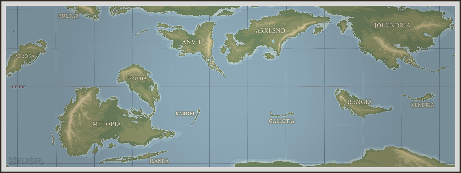
Mapfolk serve two purposes in their career: outwardly, they are guides, navigators and negotiators who help the visiting foreign folk become acquainted with the local customs of the wonderous cities of the commonwealth. Their ulterior goal however is to make sure that the commonwealth maps are so useful that they're spread globally - slowly replacing the map projections used by The Jolundrian Empire. Despite technically being the same projection in terms of distortion, the common and imperial maps differ wildly in style and function.Common Projection

by TJ Trewin
Imperial Projection

by TJ Trewin

Melior common projection map (placeholder WIP, not currently labelled in Rréraliázi) by TJ Trewin
A comparison of common (above) vs imperial (below) map projections.

Map of Melior, imperial projection by TJ Trewin
Alternative Names
Mapmen
Type
Education
Other Associated professions
Related Locations
Cardinal directions
Clock-wise, the cardinal directions are Aurus, East, Selith, and West. An easy way to determine your direction is to know that the sun rises in the East and sets in the West.
Click and drag to rotate the map, scroll to zoom in or out!
Click the globe to stop it spinning. Wait 5 seconds for it to resume again.
Click the globe to stop it spinning. Wait 5 seconds for it to resume again.

by TJ Trewin
Alongside the common language and map projection, the Melopian Commonwealth seeks to standardise and simplify as many aspects of daily life as possible, including their common calendar, which is often also distributed by the mapfolk in the form of a large brass coin or medallion along with local maps. The popularity of hiring mapfolk guides and buying souvenirs has grown the tourism trade massively, and the commonwealth has launched an initiative to fund the construction of "welcome huts" near urban rifts. Cultures on the other side have taken note and are adopting this custom, allowing native folks of Melior to trade maps, stories, and traditions with each other.
Remove these ads. Join the Worldbuilders Guild


Great article! It's fascinating to see how they used the different map projections to further their political goals :D
Thank youu!