Layida (la.'ji.da)
"Oh, there is nothing like a dip in the Sea of Fire to cool off after a busy day. "Kinja Bozu - Algae farmer by the Layuwamhe 25 AEC -
Layida is the continent of the element fire "Nelayi" and means fiery. It covers an area of approximately 10,500 km², making it the second largest continent in Elaqitan. Its inhabitants and main race are called Layikani, who speak Layidayala.
Geography
At a glance
Total area: ca. 10.500 km²
Largest country: Olayangi ca. 2.995 km²
Largest inland sea: Layuwamhe ca. 867 km²
Largest Island: Wajali ca. 993 km² (Wajali)
Highest mountain: Yashkala 3.966 m (Tolayulu)
Longest river: Tangi 933 km (Tangisa)
Biggest city: Zimuniya 455 km² / 250.710 inhabitants (Olayangi)
Average temperature: 47.2° C
Ressource: Balangu, Sahak, Jala, Ngiki
Important locations of Layidian magic:
Lava sanctuary (Anshani)
Fire Maze & School of Fire Magic (Olayangi)
Makori Monastery (Tangisa)
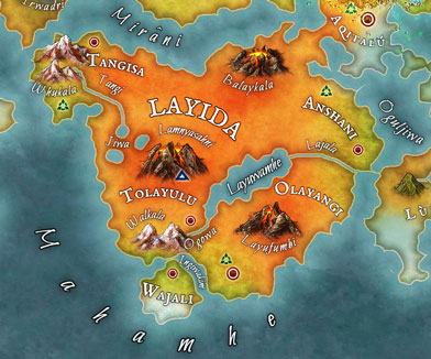
Layida is located in south-central Elaqitan. The continent is surrounded from the southwest to the southeast by the "Mahamhe", the "Mirâni" in the north and the "Oguljiwa" in the east.
Its appearance is primarily characterized by several volcanic mountains such as the "Balaykala", the "Lamnyasahni" and "Layufumbi" as well as numerous geysers and hot springs. In the north and southwest there are two other large mountain ranges "Whukala" and "Walkala". In the southeast the continent is divided by the sea "Layuwamhe" and the two rivers "Ongowa" and "Lajala". The largest river "Tangi" in the northwest of the continent flows into the "Jiwa", large hot lakes with several geysers.
In the southwest of the continent, the island of "Wajali" is separated from the rest of the mainland by the "Ingiwakim" strait.
Countries
Layida includes five countries in which women alone play the central role in society. All states are actually governed independently of one another. However, there are always conspiracy theorists who claim that from each of the individual governments a member is chosen for an even larger body that governs the entire continent, thereby preserving the role of women.
Name
Resident
Size
Government
Capital
Resident
Size
Government
Capital
Olayangi
Olayakani
2.995 km²
Magic guild
Zimuniya
Olayakani
2.995 km²
Magic guild
Zimuniya
Tangisa
Kanitang
2.490 km²
Order of Safambi
Safamali
Kanitang
2.490 km²
Order of Safambi
Safamali
Anshani
Kanishan
2.010 km²
Queen
Rijangu
Kanishan
2.010 km²
Queen
Rijangu
Tolayulu
Kaniyulu
1.145 km²
Princesses
Yulibat
Kaniyulu
1.145 km²
Princesses
Yulibat
Wajali
Wajakani
993 km²
Queen
Akibika
Wajakani
993 km²
Queen
Akibika
Tectonics
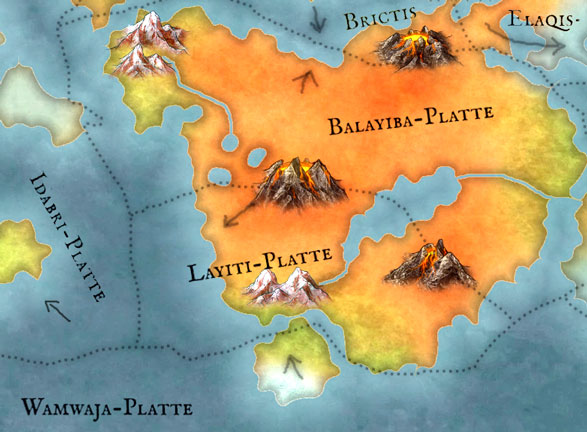
Layida lies on three tectonic plates. The north-eastern "Balayiba Plate" runs from the coast of "Mirâni" to the volcanic group of "Lamnyasahni" and "Layufumbi" to the eastern part of "Wahamhe".
This is followed by the "Layiti Plate", which extends to the coast off the island of "Wajali" in the south and borders the "Idabri Plate" in the "Wahamhe" in the west.
"Wajali" is on the "Wamwaja Plate".
Ecosystem
In the vicinity of the active volcanic mountains, the country is almost uninhabitable. In some places, the earth has a surface temperature of over 80°C. The air temperature is either very dry or so humid it's like sitting in a simmering saucepan. In some places it can even be over 95°C.
Most of the organisms therefore live near the rivers, on the western and southern sea coasts, on the slopes of the two western mountains and on "Wajali". Here the ambient temperature is usually 40° and there are frequent short but heavy rains with thunderstorms. On "Wajali" it is the coldest and drier with an average temperature of approx. 10 to 20 °C, since cold sea currents reach the island from Idaka through "Mahamhe". On the east coast to the "Oguljiwa" the ambient temperature is approx. 55° C and warm, since warm currents prevail here.
Climate zones
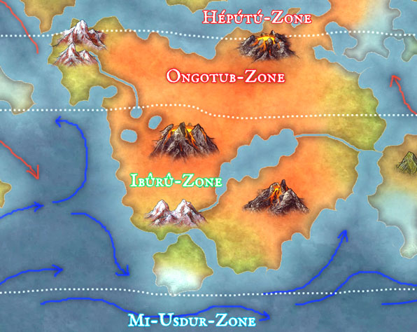
On Layida, the weather is influenced by the subtropical "Ongutub Zone" in the north and the temperate "Ibûrû Zone" in the south. "Wajali" is also affected in the south by the polar "Mi-Usdur zone".
While warm sea currents prevail on the coasts in the "Ongutub zone", the coasts in the "Ibûrû zone" are "cooled down" by cold sea currents.
Special natural phenomena
Due to the extreme heat, fire tornadoes occur again and again, causing severe devastation. In addition, there are often ball lightning during thunderstorms.
Flora & Fauna
All thermophilic organisms on the continent are adapted to the extremely high temperatures using special enzymes, which also protects the native flora and fauna from invasive species from other continents.
One of the enzymes also leads to a reaction in the cells that is responsible for the staining. The more this enzyme is produced in the body, the brighter the color of the epidermis.
Natural resources
Two important resources that are also traded worldwide are "Balangu" and "Sahak". "Balangu" is a type of glass made from liquid green-blue lava. "Sahak" is a type of basalt mined in quarries and used primarily for temple construction around the world.
As a protection against invaders, important cities and cultural sites are surrounded by a flame belt, the "Ingatolayi". For this, the residents use "Jala", a gas that is created underground by the volcanic activity of the continent and produces flames of different colors in contact with the hot air temperature. Touching the flames will cause severe burns.
The rivers, lakes and the "Layuwamhe" are never colder than 25°C due to the volcanic activity, which in some places favors the growth of the edible "Ngiki" seaweed, which is grown in farms.


Comments