The Emerald Basin
In biogeography, the Emerald Basin (also known as the Emerald Sea region or sometimes the Emerald) is the region of lands around the Emerald Sea that have what is called an Emerald Climate (dry summer climate), with mild, rainy winters which supports a variety of forests, woodlands, and scrub vegetation. The Emerald Basin is where olive trees are cultivated and grown.
Climate
An Emerald climate or dry summer climate, is the climate typical of areas in the Emerald Basin. The Emerald climate is usually characterized by rainy winters and dry, warm to hot summers. While the climate receives its name from the Emerald Sea, an area where this climate is commonplace, it is also present in other areas of the planet, although with variations in the distribution of temperatures. In addition to the Emerald Basin, the climate is also found in Sile Allanar in the nation of Acilidan, and in parts of northern Noesttas and southern Edrax.

Outside the Emerald Basin, the Emerald climate is usually located geographically on the eastern coasts of continental masses, typically between oceanic climates towards the poles, and semi-arid and arid climates towards the equator. In essence, an Emerald climate is a combination of the three climates with winters somewhat mimicking winters in oceanic climates and summers imitating dry seasons in semi-arid and arid climates. Additionally, Emerald climates tend to be wetter poleward and drier the closer it gets to the equator.
For comparison purposes, the Emerald Climate and Emerald Basin is more or less identical to that of the Mediterranean Climate and Mediterranean Basin of Earth.
Agriculture
Areas with this climate are where the so-called “Emerald trinity” has traditionally developed: wheat, vine and olive.
Wheat is the dominant grain grown around the Emerald Basin. Pulses and vegetables are also grown. The characteristic tree crop is the olive. Figs are another important fruit tree, and citrus, especially lemons, are grown where irrigation is present. Grapes are an important vine crop, grown for fruit and to make wine. Rice and summer vegetables are grown in irrigated areas.
Geography
The Emerald basin covers portions of six nations: Achana, Aredar, Kalit, Otharia, Vorroth, and Dominion of Xeshana.
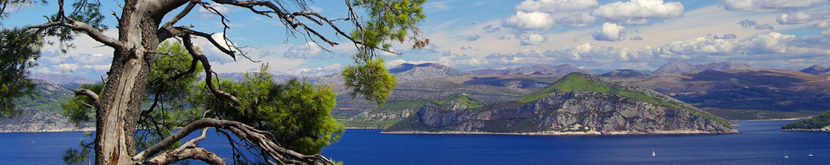
It has a varied and contrasting topography. The Emerald Region offers an ever-changing landscape of high mountains, rocky shores, impenetrable scrub, semi-arid steppes, coastal wetlands, sandy beaches and a myriad islands of various shapes and sizes dotted amidst the clear blue sea. Contrary to the classic sandy beach images one would expect to find, the Emerald Basin is surprisingly hilly. Mountains can be seen from almost anywhere.

The Emerald Basin extends into Western Achana, covering the eastern portions of the nation of Ogresh, excluding the temperate-climate mountains of western Ogresh.
The northern portion of northeastern Xeshana has a dry summer climate, separated from the Ubaimadi Desert, which extends across Xeshana.
The tyrant kingdoms lie to the north, with the Isthmus of Otharia extending into the Emerald-climate zone. The mountain ranges of Ogresh and Aredar divide the Emerald from the temperate climate regions of northern and western Abios.
Fauna & Flora
The Emerald Basin is home to a number of plant communities, which vary with rainfall, elevation, latitude, and soils.
- Scrublands occur in the driest areas, especially areas near the seacoast where wind and salt spray are frequent.
- Shrublands are dense thickets of evergreen shrubs and small trees, and are the most common plant community around the Emerald. In some places shrublands are the mature vegetation type, and in other places the result of degradation of former forest or woodland by logging or overgrazing, or disturbance by major fires.
- Savannas and grasslands occur around the Emerald, usually dominated by annual grasses.
- Woodlands are usually dominated by oak and pine, mixed with other sclerophyll and coniferous trees.
- Forests are distinct from woodlands in having a closed canopy, and occur in the areas of highest rainfall and in riparian zones (the interface between land and a river or stream) where they receive summer water. Emerald forests are generally composed of evergreen trees, predominantly oak and pine. At higher elevations Emerald forests transition to mixed broadleaf and tall conifer forests similar to temperate zone forests. The exception to this is the dense black hardwood forest of Achana, known as the famous Ebony Forest.

Natural Resources
The Emerald Basin is home to a wide variety of natural resources which contribute to a thriving trade economy. The majority of natural resources found around the Emerald Basin consist of:
- Gold
- Silver
- Iron
- Copper
- Tin
- Timber
- Wheat / Grain
- Olives and Olive Oil
- Fish
- Grapes and Wine
- Cotton
Maps
-

The Emerald Basin
Map of the Emerald Basin, also known as the Emerald Sea Region.
Type
Region
Included Organizations
Kingdom of Achana
Kingdom of Aredar
Kingdom of Kalit
Kingdom of Otharia
Kingdom of Vorroth
Dominion of Xeshana


This is remarkably thorough. I like it. I do wonder what kind of cultures live in these areas but i imagine that's in another article. I wish i could give the same amount of text you did. The only things i can think of are the people of the regions and the fauna as you say a lot about the flora but almost nothing about the animals here. I also like the pictures as they really give ab idea if what these places look like to someone who as never been to a similar location. I am one of the unfortunate few who had never been to a place with water that blue lol good job and I'll find another article :)