First Tādhēskō (/fɜːst teɪdˈhisko/)
(64,560 BP - 54,100 BP)
The First Tādhēskō1 was a slow, steady recovery that lasted just over ten thousand years.2
Climate and Ecology
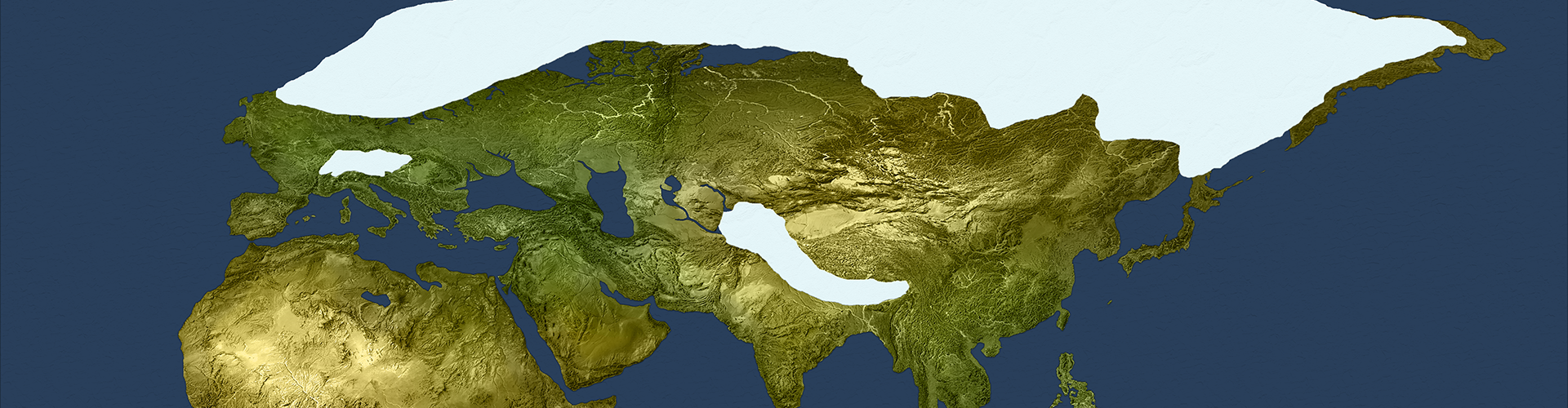
There was no sudden or dramatic event to signal the start of this turning. Instead, global temperatures gradually climbed century after century, resulting in warmer summers and shorter winters. The massive glaciers that covered Europe and northern Asia at the start of the turning began to recede, and deserts in Africa and Asia shrank and became less extreme. Ecosystems worldwide recovered from the previous ice age and began to flourish.Flooding of Nikonhai (59,330 BP)
The Nikonhai basin had only recently emerged as dry land in the previous turning. It became a refuge for wildlife forced out of their habitats by glaciers, and vegetation flourished in the basin even at the height of the ice age. As the climate improved during this turning, water poured into the basin from the melting glaciers in the north while the sea level rose to the south. Although there was no sudden or dramatic "flooding" event, eventually the water took over the basin and Nikonhai sea reappeared.Flooding of Euxine Lake (57,205 BP)
The flooding of Euxine Lake, on the other hand, was much more dramatic. Euxine Lake and Mazandaran Lake had both gradually been increasing in size as they accumulated glacier meltwater that was fed to them via tributaries from the north, but Euxine Lake remained below sea level for most of this turning. It was only when the Medhydg'hem Sea finally rose high enough to breach the land bridge at Mysia, water roared into the valley and surged at full spate for an entire summer. Euxine Lake doubled in size, with a permenent waterway connecting it to the Euxine Sea.The meltwater lakes (55,000 BP)
As the massive glaciers covering Sibir retreated, meltwater collected in the lowlands to form cold freshwater lakes: Mansiyskoe Lake to the east of the Ural mountains and Lake Komi to the west. The water of Lake Komi found a network of tributaries that allowed it to drain into the Mazandaran Lake and Euxine Sea. The meltwater flowing into Mansiyskoe Lake, on the other hand, remained trapped, causing it to grow continuously throughout the turning.Cultures
This tādhēskō began with very few people. The preceding ice age had been very hard on every species: the human population was 1,200 people, the denisovan population was 800 people, and the neander population was slightly under 2,000 people. This turning gave them all a chance to grow, rebuild, and explore.Emergences
As warmth and moisture returned to ecosystems around the world, travel became easier and the prospect of setting out to find opportunities in new lands became more appealing. Three "green corridors" opened up, enticing people to explore: a corridor in eastern Asia from Altai to Sunda, a corridor in western Asia from the Levant to Airyanem Vaejah, and a corridor in Africa from Kemet to Kasai. When the Baishiya denisova looked southward they began to see patches of green bloom in distant plains, and forests starting to appear on lands that had been barren for as long as anyone could remember. Although most denisova were content to build up and grow the community they had established in Altai, a few young adventurers wanted something new. They set out on an epic adventure, first eastward toward the coast and then southward, on a journey that lasted nearly the entire turning. Although the travel was slow and sometimes difficult, they kept their eyes looking southward. In 56,500 BP they reached Wallacia, an isolated penninsula in Sunda where they could live undisturbed near the water. They became the Bougain denisova. The peace and cooperation that characterized Emiran culture for more than twenty thousand years began to deteriorate when life became more challenging during the Ougrosian ice age. There were some humans blamed their hardship on the fact that they were sharing their culture with neanders. These tensions grew, simmering under the surface, until the improving climate of the First Tādhēskō seemed to offer an opportunity. Deserts were receding to the east, and greenery was appearing on the distant hills. To some of the younger and most angry Emiran humans, it was the chance they were looking for: they set out on their own to create their own "pure" human society, unburdened by neanders. One group followed the path and then veered northward, forming Kulbulak culture in Airyanem Vaejah, while the other group veered southward into Indus where they encountered the Esea people. Some stayed, mixing with the Esea and triggering a shift to Adivasi culture, while others continued eastward through Indus until they reached Zomia, resulting in Sơn Vi culture. These migrations planted the seeds for the "Initial Upper Paleolithic Expansion" that would ramp up in the next turning. Aterians in Kemet and Sa'hra sensed that the climate was improving, and groups of explorers frequently would follow new green pathways drawing them westward. These expeditions gave rise to the large number of small cultural pockets that collectively became the First West Africans who were the ancestors of the diverse set of indigenous African groups existing in that region today. The improving climate and more frequent contact with clans caused the Laetolibe to transform, adopt new skills and practices, and become the Wahadzabe.Encounters
In a somewhat ironic twist of fate, the Kulbulak humans, who left Emiran culture because they didn't like having to live along-side neanders, happened to settle near lands already occupied by Teshik-Tash neanders. Naturally, the Kulbulak humans were resentful, antagonistic, and xenophobic. Even within their own clans they had very little tolerance: One family was exiled for having a daughter who dared to have "relations" with a neander boy. That group headed northward with family and established Ust'-Ishim society in Ariana. Another group became unhappy with the constant aggravation and conflict between the Kulbulak humans and Teshik-Tash neanders, and so headed westward past the Urals and into the Pontic Steppe, founding Bacho Kiro culture.3Extinctions
Apart from the fact that Esea culture disappeared when it transformed into Adivasi culture, no other cultural groups died off or disappeared during this turning.Culture Map
It is important to remember that the map below does not represent all movement by all individuals of every species of person during the turning. This map captures only some of the most significant changes in a selection of the larger cultural complexes.First Tādhēskō
"First Recovery"

Turning Type
Period of Recovery
Preceded By
Start Year
64,560 BP
End Year
54,100 BP
Succeeded By
World Maps

64,560 BP: start of the First Tādhēskō

54,100 BP: end of the First Tādhēskō
Detail Maps
")
Meltwater lakes of northern Asia (54,100 BP)

Eastern Corridor created by warm, wet conditions from 64,000 to 54,000 BP

Central Corridor created by warm, wet conditions from 64,000 to 54,000 BP

Western Corridor created by warm, wet conditions from 64,000 to 54,000 BP
Graphs, Photos, and Illustrations

Territory settled by the nomadic Teshik-Tash neanders, who were disrupted by the arrival of the Kulbulak humans

Wetlands settled by the Ust'-Ishim people.
Footnotes
1. The convention of using the label tādhēskō to refer to a recovery turning that follows an ice age began with Ficino (1485), who described a framework in which turnings alternated between prunsō (freezing) and tādhēskō (melting) types. Edward Kelley used the label tādhēskō to identify one of the turning categories in his fourway typology, but did not use it as the name of any individual turning. The current convention of numbering recovery turnings rather than naming them was established by Kenneth R. H. Mackenzie (1881), although his identification of the tādhēskō turnings differs slightly from the current accepted model (for further discussion, see Part 3: Theoretical Frameworks in Appendix A). 2. The First Tādhēskō corresponds roughly to the periods of time humans have identified with the labels Oerel Interstadial, Würmian II, and GIS 15/16, and spans the MIS 3/4 boundary. Because this turning is characterized by slow and gradual recovery and has no harbinger event, it is more difficult than other turnings to identify corresponding boundaries and periods in paleogeology and paleoclimatology. 3. The attitude of xenophobia and separatism among these humans was aggravated by the realities they were forced to encounter as new immigrants in lands where the neanders were the indigenous population. The Kulbulak humans had to deal with Teshik-Tash neanders, and the Bacho Kiro humans had to deal with the nearby Mezmaiskaya neanders. Recent archeological evidence shows that these human groups maintained a high level of genetic isolation, while frequently picking up habits and practices that they observed being used by the indigenous neander populations that they eventually replaced (see Hublin, Sirakov, et al., 2020). The ambiguity that has given rise to debate in recent years over whether specific carvings and tools in the Bacho Kiro region were created by humans or neanders is actually the result of humans engaging in copy-cat behavior, imitating the neander groups while at the same time shunning them. This makes the tools at Bacho Kiro among the very first examples of cultural appropriation.Turnings Index
Type Key