Marodeen Sea
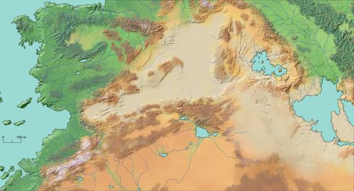
The Marodeen Sea is a vast desert basin separating the continents of Subrosia and Eukatetica. Thousands of years ago, it was an actual sea, but today is a largely barren wasteland of blinding salt flats, treacherous salt mountains, and lifeless salt lakes.
Geography
The Marodeen Sea spans about 2,500 miles, from Atra in the west, to Figbal in the east, and covers nearly 1 million square miles. It forms a huge basin that is mostly below sea level - almost a mile below, on average - with the exception of a few mountainous regions, such as the Aldoz Highlands. It is roughly divided into the Upper Marodeen Sea, comprising the western third, which has a slightly higher elevation and is almost entirely flat; and the Lower Marodeen Sea, comprising the eastern two-thirds, which is more geographically varied and contains several hypersaline, endorheic lakes. The two portions are separated by a region of intense volcanism and frequent earfquakes, southwest of the valley of The Prijan.
Ecosystem
Definitely favors halophiles.
Ecosystem Cycles
Extremely, extremely hot and dry most of the year, but in the winter months, sporadic rainstorms will turn areas into massive, shallow ponds or treacherous flash flood zones for brief intervals.
Localized Phenomena
- Salt storms (haloboobs)
- Quicksalt
- Earfquakes except here they're called "salt shakers"
Fauna & Flora
Not much. Sponian Camels like it. Innumerable legends of terrifying desert denizens have followed the merchants and caravan guards along the Salt Road over the millennia, as well as rumors of assorted mythical paradises.
Natural Resources
- Salt. Does salt count?
- Abundant deposits of both sodium and chloride, in an almost exactly 1:1 molar ratio, somehow.
- Sunlight
- Wind
- Heat
- Dry bones
- Actually quite a bit of mineral wealth out there for the taking, if you knew where to look and could handle the elements.
History
Used to be an actual, water-filled sea, ringed with great cities and nations, and dominated by the maritime trading prowess of the Marodeen Thalassocracy. Between 4000 and 5000 years ago, however, it dried up almost entirely. Although the Salt Road, a caravan route across the Upper Marodeen Sea, eventually reestablished trade between Eukatetica and central Subrosia, it was not enough to sustain the majority of the settlements that had depended on the sea.
Tourism
Nope.
Type
Salt flat
Location under
Included Locations
Included Organizations
Related Ethnicities
Inhabiting Species
Related Myths


Comments