
Oceania
Our world is still unexplored. We know where the lands are, and how if you sail in one direction you hit the opposite side of the world. Our planet has been measured using shadows and poles, we know how large it is. But aside from general observation, what we have personally observed? We know nothing. Of course, we can identify the causes of the red pox, we can cure fevers and chills, we know what is safe to eat, where to harvest the best fish, what routes between our islands and continents are fastest and safest-- but after that? After all of that surface observation? We know nothing about our world. From the highest peaks of Alpta to the islands of Brosha, we can observe all we want, but until we may learn how our world is made up, until we know what lives here with us, what lives on the other side of the ocean, we cannot truly understand our world. Part of a speech delivered by Jun Po, noted researcher, 1492
Geography
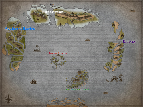
The largest feature of this planet is the ocean, taking up most of the world itself. The landmasses are divided into continents and islands, multiple volcanoes also rising from the sea.
The landmasses themselves vary wildly. While the Brosha Islands may tend towards flatter islands with steep mountains and hills, dotting them with thick jungles, Alpta is nearly exclusively mountains and valleys marked with short grass. The Eilt Un Archipelago is much like Brosha, flat; but it is dotted with deciduous woods and swampland.
The Continent tends towards evergreen forests and high cliffs, often bearing cities on the very edge looking down at icy oceans. From there it descends into plains of ice with a noted area being a series of valleys through ice shelves higher than the largest ships. Even between countries it changes. Jestoania's cities all lie on cliffs, their travel inland almost impossible due to high elevation and a land filled with valleys and crevices from centuries of ice growing and shifting. Iospadia lies farther south, safe from the harshest winters, and there the ground is more even, steep terrain shifts only occurring at its inland borders. Gostary is forest, its peaks rising high into the air, and its rivers are wide and shallow.
To the west is Aquimore, known for constant rain and steep rolling hills. Their land changes from dense plant growth to open plains on the edge of sheer cliffs and narrow valleys.
Estrea is another mass of islands, though these are so densely packed together they often join together to form mountains and rock formations, separated only by narrow rivers and occasional floodplains.
Maps
-
Early Oceania map
An early map of Oceania, dated to around 1130. Hot debate has sprung up since then about distance between landmasses, with some moving the land farther apart, while others push it closer. Alpta is noticeably missing from the map as well, while Eilt Un is much larger than in measured actuality.
Type
Planet
Included Locations


The prose in the beggining always gives an additional flavour to the article. I like how your map was supposedly made by someone in your world.