Mashiq
And here, at the edge of the Sea of Brass, where the morning sun peers over Shanindar and warms all with His benevolent Rays, you shall find a home in the bosom of our LORDS." — Heavenly Codex "Book of Uriah"
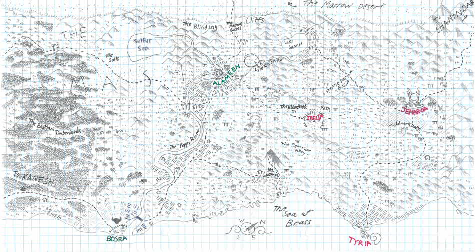
The Mashiq is an approximate historical geographical term referring to a large area along the southern coast of the Nioan continent. The term comes from the Old Temekanian word for "rising" referring to the sloping nature of the landscape beginning with shores of the Sea of Brass in the south and rising to the Blinding Cliffs in the north which separates the Mashiq from the Marrow Desert. The region is extremely geologically varied with mountains, valleys, fresh and salt water lakes, forests, deserts, and grassy steppes all found within the territory.
Since the The Mithril Era, the region has played host to a myriad of cultures and states and features prominently in the religious and political history of major empires and faiths of Nioa, Auloa, and Iroa.
Geography
The geography of the Mashiq is exceptionally varied, resulting in many subregions with unique climates, elevations, and biomes. In the mythology of the Heavenly Codex, the region's diversity is the result of the early upheavals of the War of the Dawn, a conflict fought between the Gods of the Heavenly Council and the forces of the Unspoken.
Beginning in the west, the region of the Mashiq meets with the Kanesh, a peninsula that extends south into the Sea of Brass proper. At its western most extent, the Mashiq is comprised of a vast primordial timberland called the Bashari. It is the largest forest on the Nioan continent and Nioa's primary source of timber. The forest is located in a highland region, drawing in moisture from the Sea of Brass and the Lazuli Ocean to the west.
From here, the land slopes down and becomes divides between a series of hills. To the north, the land is cut off from the life giving rains of the seas and the low elevation causes the water to pool and evaporate without the draining of sediment. This region is called the Salts, and is one of the driest and most inhospitable areas in all of Nioa. At the center of the Salts lies the Sulfur Sea, a massive saltwater lake situated over a series of volcanic vents. The Sea is exceptionally salty, allowing individuals and objects to float but also denying any life other than brine shrimp from utilizing its waters.
Yet deep in the low mountains overlooking the Salts, a small river gathers strength before running south and meeting with the Lyre Run from the Gennesaret's hills. These two tributaries combine to form the greater Poppy River, the largest river in the Mashiq. It flows through the city of Alameen, the largest settlement of the region, and then south until it reaches the Bosh Delta and the Sea of Brass. The Poppy River provides the Mashiq with a great deal of arable farmland and is the most economically prosperous section of the region, with nearly half of the region's population living along its banks. However, the River's headwaters and climate make it unpredictable and prone to bouts of drought and flooding.
A more stable, if slightly less fertile region in the Mashiq is the Gennesaret Basin, a valley located beyond the Lyre Run's source. Hemmed in by mountains to the south and the Blinding Cliffs to the north, the Gennesaret should have suffered the same fate as the Salts, yet the great body of water that feeds the valley, Lake Gannet, is full of fresh water and free of volcanic activity. The area acts as the breadbasket of the western Mashiq, but because it is surrounded by rough hill country and away from major trade routes, the Gennesaret lacks the large settlements seen by the Poppy River or on the Jeharoan Plain.
South of the Gennesaret is an arid plain called the Bleached Path. Trapped in the rain shadows of the Gennesaret and the Castorai Range, the Bleached Path is a rocky, barren wasteland. No water flows here, yet because of its position between the East and Western Mashiq, the Path serves the the Mashiq's most important trade route, connecting the economic hub of Alameen with the great place of pilgrimage, Jeharoa.
On the otherside of the Castorai Range stands the grand Mount Castorai itself. The mountain features prominently in the stories of the Heavenly Codex and early cultures believed that it was connected to the Celestial Mountains where the Heavenly Council actually dwells. The mountain looks out over two vales; one filled with dry, inedible grasses called the Demonscar Valley; and one which slopes down to the Sea of Brass, called fittingly, the Brazen Hills. The Brazen Hills are relatively fertile and provide food for the number of monasteries and religious retreats located in the Demonscar and the foot of Mount Castorai itself.
The westernmost part of the Mashiq is Migdal, sometimes called the Jeharoan Plain. The plain is filled with arable grasses and breezy steppes that lie in the foothills of Shanindar Mountains to the northeast. It does not have enough large bodies of water to support the kinds of population centers found along the Poppy River, but a number of small rivers and streams flow from the edges of the Shanindar. These, along with grain from the Gennesaret, provide enough food to feed the Holy City of Jeharoa, arguably the most important religious site in all of Holos. The plain extends all the way south to the Sea of Brass and the limestone bluffs of Tyria, the Mashiq's largest port city.
Maps
-
The Mashiq (Map)
A map of the Mashiq in 362 SE
Alternative Name(s)
The Brass Coast
Type
Region
Included Locations
Related Ethnicities
Inhabiting Species
Related Plots
Related Materials
Comments