The Warring Lands
"The Greatwyrms ravaged Western Drumis, starting with the Purging of Isodemos's Brood and ending with the Flight of the Reds. Thousands died and many thousands more were displaced, and after? People wanted what was left."
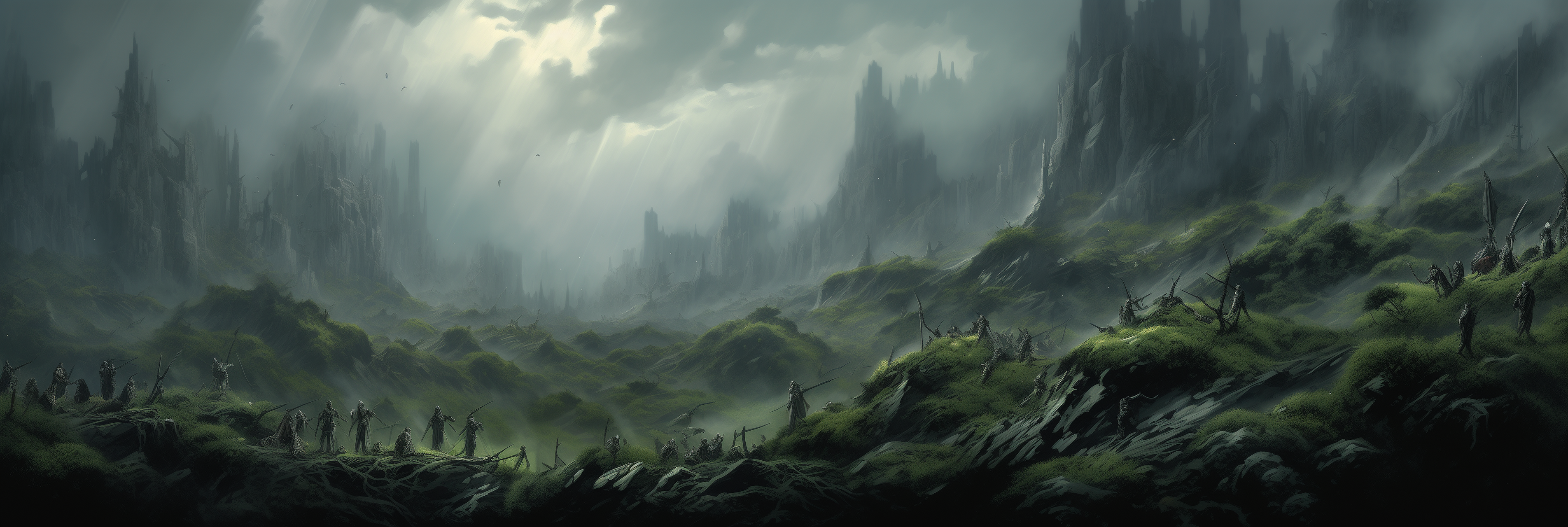
The Warring Lands is a historical and political region, the bulk of which is Western Drumis and the Tawarakanai Archipelago. These lands earned their moniker on account of the myriad conflicts and political changes that have marked the region throughout the Age of Ancients, and that continue to mark them so.
Listed here are the points of interest, subregions, and nation-states which dot and divide the Warring Lands, as well as some defining characteristics of the area. Trek them at your own peril.

 On the northern end of the Ruin, in the monolithic Wall of Drumis, are the ruins of Isodemos's lair and brood. The corpses of dozens of dragons litter the scarred cliffs and caverns within. Isodemos himself died here, and from his gargantuan, ever-decaying but never-decomposed corpse a waterfall of acid and pestilence rolls down the mountains.
This acid rolls south across the wilds that were devastated in the battle, creating the pestilent, acidic boglands that form the majority of Isodemos's Ruin. It is said that insane and even undead dragons haunt these decaying lands, alongside countless other horrors.
On the northern end of the Ruin, in the monolithic Wall of Drumis, are the ruins of Isodemos's lair and brood. The corpses of dozens of dragons litter the scarred cliffs and caverns within. Isodemos himself died here, and from his gargantuan, ever-decaying but never-decomposed corpse a waterfall of acid and pestilence rolls down the mountains.
This acid rolls south across the wilds that were devastated in the battle, creating the pestilent, acidic boglands that form the majority of Isodemos's Ruin. It is said that insane and even undead dragons haunt these decaying lands, alongside countless other horrors.
 Draconians and dragons still call Akkar their home in the wake of Ayrvorailth's defeat here, as do many elementals and deepfolk who have awakened from Akkar's geological activity. Deep are the caverns beneath the volcano, and hot is the lava that gurgles forth from its high caldera. The people of nearby Lingmell pray to Kaedo every day that Mt. Akkar never becomes truly tempestuous, and that day has never yet come.
 Powers move to claim these ancient sites and the artifacts within, knowing full well they could find the means to change the world. Whether or not that change would be for the better is anyone's guess, especially when one remembers that the Obsidian Lords ruled Drumis in the Reckoning, according to most legends.
The Cradle of the Lost
The Cradle of the Lost is the name given to the valley between the Iron Ramparts and the Gloumeda Mountains, which is largely the river valley of the Donnalin and the Xeshur, including Lake Stillbend and Islingneau Lake.The Xeshur River
Several exploratory and settlement efforts have occurred during the Age of Ancients, but all have failed within a few years. Villages disappear, expeditions vanish, and the scant survivors tell tales of ancient horrors, dark ruins, and untold secrets from before The Reckoning. As such, it grows increasingly tantalizing to adventurers, explorers, and settlers, but remains an elusive and dangerous prize.
Isodemos's Ruin
Filling the surrounding wilds with the smell of acid and melting stone, Isodemos's Ruin is a scar in the land beginning in the Wall of Drumis and stretching a hundred miles south to the Lonely Basin. It is a desolate land of swamp-like vegetation growing sparsely between bogs of vile acid and gas. It was here that the traitorous black Greatwyrm, Isodemos, and his brood were felled by the other Greatwyrms.Mt. Akkar
Whether Mt. Akkar was a dormant volcano or simply a normal mountain before the War of the Greatwyrms is anyone's guess, but the year-long stay of Ayrvorailth, Vyllath's successor and the second red Greatwyrm to fight---and fall---in the war, turned Mt. Akkar into the geological hotbed it is today. For two hundred years, Mt. Akkar has belched lava down its cracked mountainside and created a slowly-expanding plain of lava flats around its base.Pre-Reckoning Ruins and Relics
Pre-Reckoning artifacts and ruins dot Drumis's landscape in far greater numbers than anywhere else on Emaxus. These locations are mystical, powerful, and dangerous, luring countless adventurers and explorers to their dooms---and, sometimes, to their prosperous futures. As civilization has continued to reclaim Drumian lands that were lost in the Reckoning, so too do modern Emaxians reclaim the marvels (and horrors) that their ancestors created before and during the Reckoning.Scars from the War of the Greatwyrms
The War of the Greatwyrms impacted all of Emaxus---and much of wider Yophas---and there were few places it as felt more than in Drumis. Both battled over Western Drumis, decimating any mortal settlements caught in the crossfire. The territories of Waelcombe and Cambolton were especially devastated, leading to them each being conquered and incorporated into larger nation-states later.Maps
-

The Warring Lands
This map depicts the Warring Lands (which included Western Drumis and the Tawarakanai Archipelago) as they were in 612 AR. This region came by its name by the conflict and political change that defined the region from the end of the War of the Greatwyrms and throughout the Age of Ancients.
Alternative Name(s)
Western Drumis, The Old Lands, The Land of Godfall
Type
Region
Location under
Included Locations
Included Organizations
Remove these ads. Join the Worldbuilders Guild


Comments