The Wingspan
The Wingspan is a mountain range to the north of Mirandus consisting of 48 distinct summits. The weather here can shift from tropical to arctic in mere hours. The higher you climb the tougher it gets, until even oxygen is stripped away. Many pilgrims ascend the mountains in search of their spiritual eureka.
Geography
The Wingspan is a bow-shaped mountain range of Astoria that ranges in an 800 km arc from east to west. The range stretches from the Sea of Serenity extending through Spire, north of Mirandus, and stretching westward through Thullurn. Giant cliffs form a natural fortress. Where the Wingspan intersects with Spire alpine valleys flourish with flora and fauna; the higher ascent of the mountains become increasingly barren.
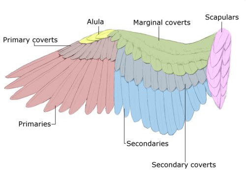
The "coverts" of the Wingspan have been crossed for war, commerce, refugees, and pilgrims. Passes through the mountains include routes by road and across bridges. These passes typically lead through depressions in the mountains connecting valley settlements. Decades ago hospices were established by the Jawen Monks at the summits of many of the main passes.
Alveolus
The Storm Pass
The Arcorar Pass
The Trail of Hooves
Notable Landmarks
The Infernum
The Infernum is a dormant volcano in a northern cluster (the "coverts") of the Wingspan. It is the home of an infamous dragonlord known as the Firebrand.
Alveolus is a series of tunnels which snake through the centermost mountains of the Wingspan, ending in all four cardinal directions. The size of these tunnels ranges wildly from small as a dire rat to wide enough to permit an owlbear to travel through. These tunnels are the only widely known entrance into the Underdark; however, the passages are dark and labyrinthine—only expert guides can navigate without getting helplessly lost. Some archaeologists and diviners speculate that the tunnels were formed by purple worms, a species of wingless cousins to dragons. Other experts have found evidence which suggests the presence of subterranean humanoids called Formians, who may have created then abandoned the tunnels long ago.
The Storm Pass is a narrow ravine connecting southern Astoria to the valley kingdom of Thullurn. The pass was a historic trade route between Surntra and Thullurn; however, after the Profane War, the Urdunnir dwarves summoned storm elementals to protect the valley from any northbound invaders.
Arcorarpass is a mountain pass through Piedmont, an alpine lowland, towards Spire. It is one of the principal passes of the eastern Wingspan. Arcorar is an elven word which translates to "The Great King Forest." At lower altitudes, loggers harvest pine trees and harvest hay for winter fodder. The pass is currently controlled by Piedmont, a duchy of Westreach. The road is wide enough to permit the width of two horses and is paved with stones.
The Trail of Hooves is the westernmost pass through the Wingspan. It is the traditional crossing place of nomadic centaur tribes. Every autumn, over 2,000 centaurs journey south from the steep mountains to the plains to graze on winter pastures. The journey takes three days, crossing streams and enduring tempestuous weather. Around ten centaurs die every year from the dangerous crossing—either from predators or exposure to the elements.
Fauna & Flora
Flora
Thousands of species of plants are native to the Wingspan. A few notable florae are wolfsbane, which is found on the Monkshood mountain; edelweiss, a rare medicinal flower which grows only on Wingspan mountaintops; and the vampiric mandrake. Lowland trees include oak, beech, ash, and sycamore maple. At higher elevation, pine trees and shrubs grow in isolated pockets.Fauna
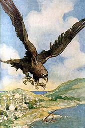
Fauna includes mountain goats, dire bears, and subterranean-dwelling dire rats. The incredibly rare roc nest on rocky ledges, hunting prey as large as juvenile whales. Their nests as sometimes as large as 60 feet in diameter and are made from piles of trees, giant spider silk, and shimmering dragon scales.Natural Resources
The Wingspan mountains are a rich source of rocks and minerals for mining. High Elves mined copper to the north; later, Reachers mined gold for gold pieces in the lower-east area by Mirandus and Piedmont. Urdunnir dwarves historically made adamantine from iron veins throughout the Thullurn Valley. Aether geodes are found in sporadic deposits throughout the mountain range as are crystals such as selenite, galena, and quartz.
Water from the Wingspan provides water for drinking and irrigation to the majority of the continent of Westreach. Major rivers flow from Mirandus, such as the Beltz River, the Serpens, and the Glister, into neighboring kingdoms and emptying into the Sea of Serenity. The Menelmen ("skyway") River begins as glacial meltwater, flows into Lake Fhaor'alusyolkiir (elvish for "transformation of the water meteor"), and from there to Freeport.
Alternative Name(s)
The Calligo Cordillera
Type
Mountain Range
Owner/Ruler
Inhabiting Species
Air
Mountain Clusters
The Wingspan Mountains are named because of their resemblance to the wind of a bird. The range is roughly divided into four clusters:- The largest stretch of mountains is (appropriately) called the Primaries and encompasses the kingdom of Thullurn and the lowlands where the centaurs migrate.
- The Secondaries are limestone peaks and alpine forests to the south which house Mirandus and Piedmont respectively.
- The Scapulars include a small cluster of mountains to the east where the high elves built Spire.
- The Coverts are the northernmost, snow-capped mountains. The monk stronghold of Haegan is located within these mountains.
- The largest mountain in the range is a snow-capped peak to the north called Mt. Alula.
Indigenous Humanoids
- Urdunnir Dwarves
- High Elves
- Centaurs


Comments