
The Southern Continent
General Features
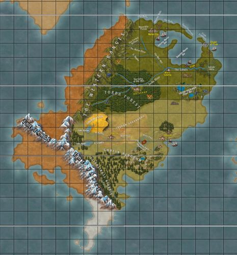
The southern continent is the largest of the bodies of land in the World. Its most northerly point lies midway between the First North Tropic and its most southerly point lies nearly to the Third South Tropic. The continent has many varied climates and formations of land- from grassy plains to alpine peaks to the Great Delta of the Mighty Luhain River and the deep and ancient Yorba forests and the magnificent and strange cockpit country of the Maanchite hill-lands. Most of the continent is the domain of the Kingdom of Sundia and all the Peoples therein are pledged in fealty to the Throne of Maron, the royal seat of the High Prince of Sundia. The Peoples are not only Man (of Sundia) but also The Goblin and The Gibkhin in the south-east of the continent, and the fascinanting Horse-folk of the Sanmar Plains, who are highly sentient equines and possibly magickal, as the Keeper of This Chronicle has discovered over many years of travel. Dark elves are also found on this continent and the lands of their abode in the east are held to be the domain of thee Kingdom of Sundia, but whether they expressly pledge fealty to the Thorne of Maron is not clear to the Keeper of These Chronicles. But the purpose of this entry is not to expound extensively on the Peoples and Powers of the continent, but to make general description of the physical land and its vagaries of climate and terrain, with light reference to some pertinent point about the inhabitants. Other entries in These Chronicles will be devoted to the Peoples and Powers of the continent wherein such matters will be treated in a more substantial manner.The Mountains
Two mighty mountain ranges traverse the continent. To the west, stretching from north to south for almost the entire length of the continent are the mountains of the Western Range. And far to the south, rising to astonishing height, are the snow and ice covered peaks of The Fangs.The Western and North-Western Lands
The land to the west of the Western Range is long and narrow in shape there being little land between the mountains and the sea. The lands there are sparsely populated with the people living in the mountains or on the coasts in the main. Many stretches of this land are dry or desert, with only dry and scrubby vegetation once the traveler descends the mountains and leaves the alpine forest behind. The Peoples of the west are Men and citizens of Sundia, though they seem to care little for what happens beyond the mountains. In the northern portion of the continent, to the east of the Western Ranges, one will find the verdant expanses of the Maanchite Province of the Kingdom of Sundia. Travelling from the mountains, first there are the rolling foothills of the mountain ranges, then the flat plateau of the Maanchite Tableland. The Tableland stretches east and also northwards, where it flows unimpeded to the sea. There it forms the Maanchite Buffs, a length of high white cliffs along the the northern coasts of the continent. The cliffs are brilliant white except in one place- the curious Blackrock Walls. Higher than all north-laying cliffs and made of sleek polished obsidian stone, these strange cliffs rise from the boiling seas, silent and inscrutable, the embodiment of enigma. In many years of study, the Keeper of These Chronicles has found no sound explanation for the existence of these rocks, so out of place among the gleaming white limestone of the Maanchite Buffs. Though the Tableland is broadly flat, the fine topography is much more varied and interesting. Of particular note are the Cockpit Hollows, a lush landscape of conical hills laced with deep cool valleys and intricate, mysterious caves. Though there are no proper rivers, but the land abounds in water- springs rise and quickly disappear, labyrinthine cave wend deep into the earth and the rush of flowing water can be heard all around- if the ear is pressed to the ground or against the walls of the caverns . But care must be taken when travelling through the Hollows, for the area is much pocked with sinkholes, (called cockpits by the people of the land). To the east, the Tableland gently slopes down to the Sea of Maron. If one could fly like sorcerers, and view the Sea from the air, it would appear as if a giant hand has carved out a great hole in the continent and filled it with the ocean waters. The Sea of Maron is a circular basin, separated from the rest of the seas by a narrow passage between the cliffs of two peninsulas. The north-lying Peninsula of Sarve curves around the head of the continent to the east, continuing the high buffs that began at the fringes of the Maanchite Tableland. Then, the Peninsula of T'rah curves up from the eastern reaches of the continent to meet the Sarve across the Strait of Maron and though the T'rah cliffs are not so high as the Sarve, the shimmering white buff of the eastern headland can oft been seen on clear days from the City of Maron. The Sea of Maron lies in two parts, a larger circular water called the Maron Superior, whose waters can be fractious and stormy at times, and the Maron Inferior, which is of calmer temperament. Hence, the Inferior is the location of the magnificent, sprawling Docks of Maron, renowned of old as a place of great commerce and the finest of all the harbours in the World. Strange as the Sea of Maron is in its form, it brings many benefits to the people of the land. In particular, it offers quick passage to the eastern parts of the continent. The time it might take to travel across this great expanse of land, from the north and west of the continent to the eastern part, is much reduced if the traveller sails across the Sea of Maron rather than travel overland. The opposing headlands of Sarve and T'rah are also of great military importance, for the Strait can be used to corral and contain enemy ships in a forced tactical pinch, to the advantage of any maritime defenders of the land. If the traveler disdains the sea, or dislikes ships, they may choose to make their to the east by the great rivers of the continent. Many streams and tributaries run from the mountains and foothills in the west through the west and central parts of the continent to form the great rivers. The largest of the western rivers are the River Maron, the River Nagwa and the Miri-Miri River. These are lively courses, rushing through high-sided valleys and deep canyons, and violent and dangerous in places where the waters swirl and boil around hidden rocks and tumble over precipices in spectacular waterfalls. Since ancient times the peoples of the lands have damned up portions of these watercourses, to bend the might of the rivers to their purposes.The North-Central Lands - Fertile Plans
The courses of the Nagwa and Maron drive the traveler into the central parts of the continent, called by the cartographers the North Central . Here, the land is not so determinedly flat as on the tableland. Still the terrain is gentle, with hills, grasslands and woods, ponds and lakes. There is much good game to be had in these green central lands and there are many fine farms and estates of myriad sizes, such that it is oft called the Harvest-Lands, for the farms and estates supply the Peoples of the continent with much of their food through excellent agriculture. The Rivers Nagwa and Maron join to onto the Miri-Miri and swell its waters, so that it becomes broad and powerful as it flows through the plains and hills of the Harvest-Lands. It flows in this fashion for many leagues towards the eastern reaches of the continent. At Afre's Landing, at the start of the Luhain valley, it meets the mighty River Yorba.The Central Lands - Deep Forest
The River Yorba also flows from the west, issuing forth from the magnificent Yorba forests. If there is another place on this continent of greater fame than the Great Water Forests of Yorba, the Keeper of These Chronicles does not know of it. The deep, dense forest spreads across the continent- eastwards from the Western Range to the eastern highlands plains, and southwards to the golden grasslands of the Sanmar plains and the plains of the Ingora Savannah. The forests are vast, deep, dark and mysterious in many places, yet profoundly beautiful and home to many of the Peoples of the continent. Though this part of These Chronicles is not meant to expound on the various Peoples of this vasty continent, it would be remiss not to mention that here in these forest may be found the People of greatest number on the continent- the Yorba or Forest-folk as they are sometimes called. Theirs is the richest province of Sundia; though the rulership of Sundia sits at Maron, many say quietly that it is only so by the leave of the Forest Power. But that is as much as will be stated here- the politics of the World are treated elsewhere in This Chronicle. Within the forest are to be found many interesting features of terrain, for the forest marches across mountain, hill, valley and plateau. Flora is abundant in quantity and variety, and the forest-folk are renowned for their skill in herblore and the healing arts. The appellation of "Great Water Forest" comes from the abundance of waters that flows within and from the forest. Streams and tributaries from the mountains, numbering in the hundreds, and passing through many lakes and pools, feed three rivers that themselves grow to become of notable size and power. Unlike the rivers of the western highlands, the forest flows are for the most part unimpeded by such checks as weirs and dams. These forest courses converge at the Unity of Ohi-Miri to form the mighty Yorba. The forest rivers and streams exceed the rivers of the western high-lands, not only in numbers and in the great quantities of water that flow in their courses, but indeed in beauty (in the humble estimation of The Keeper of These Chronicles!). Within the forest, the many streams and rivers bubble and gurgle through great trees and thick foliage in vibrant hues of green, red, orange and yellow, run merrily through mist-filled gullies and surge along mighty gorges. It is not uncommon for the wanderer in the forest to chance upon a sun-lit clearing with a pool, cool and clear as the crystals of Tlandovia, fed by fine straight ribbons of falling water. The River Yorba, deep and powerful, born of the great abundance of water that flows through the forest, runs from the Unity of Ohi-Miri to Afre's Landing, known in the ancient texts as The Jikotar-Ato or The Place of Three. At Afre's Landing, the Yorba meets the Miri-Miri and converge to form The Luhain. It is here that eastern region begins in earnest.The Eastern Lands
The Luhain is broad, flat and gentle in its flow, compared to the upper reaches of the rivers that sire it. The river can be navigated downstream and up with relative ease, and much trade and travel traverses its waters at all times of the day and year. This is the land of the river-folk and there are many settlements along the banks of the river where the traveler can pass a day or night or even linger for some length of time. There is little danger of being stranded in the river-lands. At a certain point The Luhain veers close to the coast (though river and sea never meet nor are in sight one of the other at any point). IN this place, the terrain of the riverside rises in gentle slopes to the cliff-tops overlooking the Superior Maron. Here the traveler will find the odd bi-fold town of F'rah. The riverside part is called F'rah-by-the-River, and is large and bustling because of the vibrant river trade, yet quaint and old-fashioned with the languorous air of the river lands. From the top of the cliffs the town descends in a series of terraces, cut into the cliffs in such a way as to gentle the descent to the sea and the seaside part of the town, which is called, unsurprisingly, F'rah-by-the-Sea. The distinction between "by-the-river" and "by-the-sea" must always be made, at the insistence of the people of the town. For though outsiders may see them all as compatriots in one town, the townsfolk think in a different manner. The seaside dwellers live mainly on fishing and sea trade and are less affluent than the riverside dwellers, for they are situate in a part of the Superior Maron that is sometimes troublesome for ships and thus the earnings from sea trade are less than from river trade. The rivalry is not helped by the view of their riverside brethren: that the seaside dwellers are rough and uncultured. The terrace dwellers present another distinction among the townsfolk- they claim neutrality, declare the separation of "river" and "sea" nonsensical and try to stay out of the quarrels. As it nears its end, and the sea, the meandering flow of The Luhain begins to break up into many channels and rivulets, and swamp-lands appear. Then the traveler knows that they have reached the famous Delta-land of the East The delta floods each year with the rising of the river, and when the waters recede, left behind is much fertile new soil. The land yields certain crops in great abundance- rice, flax and river-marrow especially. But famine is never far off, for the river is capricious and many a year returns in floods that were unlooked for and all the planting is lost. But further away from the delta lands, mainly ranging northwards to T'rah, the Luhaini (as the people of the province are called) have directed the water away from the river in qanats and canals, and learnt how to control the flows so that they can raise grazing lands for cattle, sheep and goats, and fine farmlands that grow dates, oranges, and persimmon, rice and tamba-grain and a special grape that can tolerate the high humid heat of the land. The towns and villages on the coast have excellent fishing and many famous delicacies are cooked in the Delta coast that are made nowhere else in the land. Thus the eastern lands flourish in their own way, though the abundance of bounty is not always so great as the central Harvest-lands. From the Delta, the land rises gently to the North to the Peninsula of T'rah and the White City of the same name. The Citadel of T'rah is famous for the pure white stone of which it is fashioned. The stone is quarried from a particular place on the cliffs of the headland and is unique, not only for the purity of its white colour but also the jewel-like inflections engrained therein. Thus the white stone of T'rah sparkles and gleams in the sun and glows in the light of the full-moon, such that sailors have used ancient The Citadel to navigate the oceans for centuries. This high and many-spired fortress is the seat of power of the Dukes of the Luhain, lesser in strength and influence than Yorba and Maanchite but lords of their province nonetheless. Though sworn in fealty to the Throne of Maron, the power of the Luhain has an uneasy relationship with its master and ever there is trouble brewing in the East, such that Maron can never dare to turn its eye away, for fear of rebellion and secession.The South-Eastern and South-Central Lands
There are two other rivers of note on the southern continent- The Kirron and The Clandia. These rivers have their headwaters in the southern parts of the Western Range. The Kirron flows from the Lake Kirron, a great body of cold blue water situate high in the alpine forest of the Western Range. Further to the south and a little lower in elevation lies Lake Amke, from which flows the river of the same name to meet other tributaries and create The Clandia. The Clandia and The Kirron converge at Saenia to form the River Free, which flows then on to the sea. The River Free emerges at the coastal city of Laxanas. This city is almost as large as Maron but the ways of the southern folk are much different to the north, and the traveler in these parts could be forgiven for thinking that they had strayed into another country than Sundia. The lands between the Yorba forests and the southern River Free are a vast expanse of grass plains called the Ingora Savannah. There are some hills and plateaus, some woodland, small rivers and lakes but for the most part the Great Grass Sea stretches unimpeded to the eastern coast and the sea. This is the Ingora Province. The Peoples therein are nomads and smaller in number than the Yorba, Maanchite and Luhain, though towards the coast there are groups who have made permanent settlement in towns and villages to fish, farm and raise livestock. It behooves the Keeper of these Chronicles to make mention in this entry of the remarkable Sanmar Plain. The Sanmar Plain lies atop a high plateau at the foot of the Western Mountains, below the Yorba forests. This elevated plateau is sufficient large that two or three days journey is required to traverse it from the hills to its verge, where it begins its descent to the lower plains (that journey being by horse at moderate pace and with a few stops for rest and respite). The grass of the Sanmar Plain is golden not green, and gleams in the light like fine burnished gold. It is a great sight to below the sun rising over the horizon and casting its glorious dawn light on this great auric expanse. This is not the abode of Man or Goblin. The inhabitants of the plains are tribes of horses. The Stallion-Princes and Mare-Queens of the Sanmar rule the plateau and they alone decide who may enter their land. These beasts act as all horses do but there is a immense and deep intelligence in their eyes and they understand the speech of Man and Goblin well, though they do not utter the words. The nomad peoples of the grasslands seldom venture to the Sanmar Plain and Sanmar horses are rarely seen outside their home. Yet the Keeper of these Chronicles has found many fascinating writings on the Sanmar, in particular treaties of peace and fealty to the Throne of Solander and histories of alliances between the Sanmar and Peoples of the Lands, and the intention remains to devote a substantial entry to chronicling what is known of the Stallion-Princes of the Sanmar. The grasslands extend southward to the River Free and the river is taken to be the southern boundary of Sundia. Beyond the River Free the rest of the continent becomes increasingly cold and wild as one draws closer to The Fangs. But before the cold and mysterious mountains of the deep deep south, there are some Lands and Peoples of interest. Here, this part of this entry will be short, for many other entries will be needed to do justice to the fascinating lands and Peoples beyond the Free. The South-Eastern lands, below the River Free, from the central parts to the coast, are the realm of the Goblin Kingdom. There the land is high and hilly, and mountainous in some places, with a preponderance of lakes and pools, many woodlands, and several river tributaries that flow to the River Free. These highlands are particularly well-suited to growing wine-grapes and Goblin wine is unmatched in the World. The craft and trade in wine is the mainstay of the Goblin. Across the river, the Sundia lands also grow wine (though the north-banks of the Free are not so high as the Goblin highlands and thus not as well suited to growing the finest grapes). There is ever a great rivalry between the wine regions of Sundia and Goblin, and the Peoples of both places seem to enjoy trying to out-do one another in the quality of their vintages. The relations between Sundia and Goblin are strange, usually peaceful until the Gooblin begin a Season of War. Then the Goblin will raise armies, cross the Free and raid the southern Sundian lands. Thus Maron must maintain a goodly military presence in the south, at the garrisons at Saenia and Laxanas. This summary on the Goblin-lands cannot be closed without mentioning one of the most curious formations of terrain on the continent- the Ramaleng Rock (or Ngomeyti in the old Goblin tongue, which the Keeper of These Chronicles has been told means "Place of the Iron Spirits"). This is a great rock of red earth that rises many leagues into the air. In a feature not seen elsewhere in the World, a river called Molopo by the Goblin-folk approaches the Plateau and splits in two to circumvent the Plateau on either side. Each branch 0f the sundered river then makes its own way to meet the River Free. With knowledgeable guides from among the Goblin-folk, the curious can make the difficult journey to the top of the Plateau (if they have the coin to pay the guides and buy the necessary provisions, including prodigious quantities of wine and rhum to calm the guides' nervous natures.). At the summit, the traveler will find that the land is profoundly, almost unnaturally, flat. There are a few structures on the plateau, but the Goblin consider these edifices and their environs cursed, and permit no one to approach more that a quarter league. There is one other group of People to note in these lands. They are called the Gibkhin and they occupy lands south to the Goblin Kingdom, on the lower flanks of the southern mountain range and the foothill country around. They are more like Goblin than Man, though hairy where the Goblin possess skin like Man (albeit coloured green!). The Gibkhin are fierce; some would say "savage". Their speech is incomprehensible to most Peoples of Man and Goblin, and they are warlike towards the Peoples of the south. They also practice disturbing rituals of sacrifice. These rituals combined with their violent tendencies and inability to communicate, render travel to the Gibkhin territories quite dangerous for most.The Deep South
The farthest south-lying reaches of the continent are beyond the Goblin and Gibkhin territories. Here the great southern mountain range called The Fangs rears up to touch the sky. Oft the peaks are obscured by clouds and are never without snow, even in the hottest summers. The Fangs are the most majestic of mountains, beautiful to behold away off, especially as the day ends and the golden light of the waning day colours the white snow gold, orange and pink. In the deep south, the lands are far colder than the rest of the continent, but it grows even colder as the traveler ascends the mountains. In their ascent, they will face the threat of suffocating snow-falls, storms of giant hail-stones and frightful blizzards. All who have tried in modern times to scale these mighty mountains say the way is rough and fraught with innumerable dangers. Any mountain passes and gaps that may exist have not been found, for these pathways must lie high in the peaks and none have climbed so far in modern times. Those adventurers who survived to tell their tale all declared that sooner or later the traveler will face a stark choice- press forward and die or turn back to preserve life. Many writings declare that The Fangs cannot be crossed by mortal men, that only Gods and Dragons know what lies beyond the jutting peaks of the The Fangs. Indeed, the Keeper of These Chronicles has found writings which claim to record the words of Dragons. The Fire-Brethren declared that no other mountains in the World rise so high as The Fangs. The Keeper of These Chronicles has found little written about The Fangs and even less about the land beyond The Fangs. The writings that do speak of the mountains, and any lands that might lie beyond them, make for fascinating study- citadels of stone and ice, "mountain-men", rime-witches and warlocks and rime-magicks- but these writings are almost always ancient and indeed may be apocryphal.Conclusion
Here ends this entry, which has traversed the length and breath of the southern continent to describe its physical characteristics, though not with great detail. Many subsequent entries will be written to acquaint any who chance to read this humble Chronicle with many more fine and interesting particulars of the various regions and Peoples of the continent.Maps
-
Map of The World, Partial - Showing The Kingdom of Solandar in Detail
A Map of The World, Partial, Showing The Kingdom of Solandar in some detail and the placings of other continents. The Western Province of Solandar is yet to be completed, for The Keeper of these Chronicles has not yet been priviledged to travel extensively in those lands beyond the Western Ranges.
Included Locations

Comments