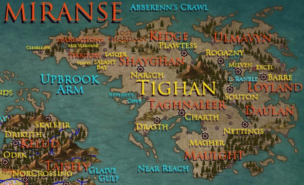
Tighan
Wardens
Armistice – Sparingtons Territory Wardens Stewards – Shayghan National Wardens Outerangers – Taghnaleer National Wardens Catalysts – Plawtess National Wardens Charioteers – Loyland National Wardens Noiters – Daulan National Wardens Vynscouts – Ulmavyn National Wardens (‘of Rogazny’) Curators – Maulght National Wardens ? – ‘Excel’ National WardensNATIONS OF TIGHAN
Shayghan
; Western-most nation of Tighan continent Capital city; Narsch Secondary cities; Aschtorn, Thervial, Doraghen Re-selling of ores and smelting in Narsch, into metals for trade are the main sources for monies for the Shayghan economy. Gold, copper and iron are the main ores sold and refined. Using their proximity to Coaseth to their advantage, the nation of Shayghan has a major trading partner in Iascter. Kelud has asked for a considerable increase in ores recently, especially steel...Kedge
; Northern-most nation of Tighan continent Capital city; Plawtess Secondary cities; Hommande, Tyairynne, EsstrapheSparingtons Territory
Lackswater Rough Town, Stag’s Reach, Civil Town, prospective new city. Families are more commonly seen here than in the other camp towns. Kax, Somewhat Civil TownTaghnaleer
South-western Nation of Tighan Capital City; Charth Secondary cities; Drasth, Alverre, Casth, MaathMaulght
Southern-most city of Tighan Capital City; Magher Secondary cities; Vaulgher, Hasp, Nomads, Naghan, Aush, Thomtyn, OchaughnDaulan
South-eastern nation of Tighan Capital City; Nettings Secondary cities; Taulkum, Retomkh, ThrughnLoyland
Eastern nation of Tighan Capital City; Barre Secondary cities; Duumaton, Berrick, Clepolse, Seagasp, LastcoveUlmavyn
North-eastern nation of Tighan Capital City; Rogazny Secondary cities; Milven, Saddervale, Jakandom, LongbowCITY STATES OF TIGHAN
Souton
-- Freeport On Lake RanbleExcel
l Free town of eastern TighanMaps
-

Miranse
-

Eastern Tighan Borders (circa 2138)
The political boundaries as recognised by the Heraldic College at the date of the Founding of Excel, the Sundered City. This is the first alteration to the divisions of Tighan since the founding of the Nation of Daulan. -

Eastern Tighan Terrain
The lands of the eastern portion of the Tighan are a mixture of grasslands and roughlands. To the west of Lake Ranble, the isolated Ghane Peaks rise, forming a central axis for the continent. The tallest mountaintops are always snow covered. In the shaded vales of these peaks, the snows manage to cover the forest trees most of the year. Occasionally, the grasslands reveal their potential and can be farmed by the inhabitants.
Alternative Name(s)
The Second Land
Type
Continent
Included Locations
Characters in Location
Related Reports (Primary)
Remove these ads. Join the Worldbuilders Guild


Comments