Red Table
Tredake (Red Table)
Area: 19,282 km2
Elevation: 894m-908m
Climate Type: Hot Desert
Elevation: 894m-908m
Climate Type: Hot Desert
Temperature Ranges:
Summer: 25-45°C
Winter: 6-20°C
Summer: 25-45°C
Winter: 6-20°C
Population: 650 Regalti
Notable Settlement: Tragan-Wreth
Notable Settlement: Tragan-Wreth
Notable Animal Species:
Desert Lekira
Desert Lekira
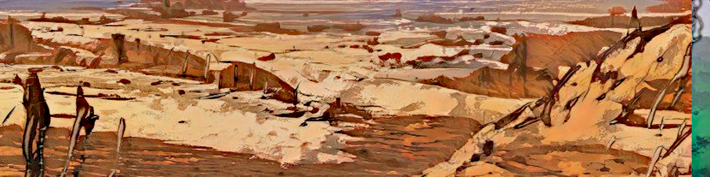
Translated directly as "Red Table", Tredake is a collection of mesas and plateaus with an average elevation of 901 meters. The plateau has a higher overall temperature from the lower elevations and also suffers from a rain shadow effect compared to the surrounding semi-arid grasslands. Recieving very little rainfall (about 300mm a year), the top of the plateau is classified as a Hot Desert. Despite its classification, every few years, winters are exceptionally cold and snowy. The resulting icemelt when spring comes is absorbed in the ground and is what powers the areas extensive hotspring system.
Though it used to be attached to the highlands to the north, it became separated after a volcanic eruption just under a million years ago. The The result is that the flora and fauna on top of the plateau is distinct from the surrounding highlands or the grasslands below.
The main Plateau and each of the five mesas each have a slightly different ecosystem, with different species of desert plants and subspecies of Desert Lekira and other animals. The Desert Lekira is the largest mammal of the region (about the size of a large dog on Earth). Most other animals are quite small. There are a few species of Skyshells that can be found floating high above the desert.
The Plateau itself and the surrounding mesas are the result of a flood basalt eruption millions of years ago. Most of it has eroded away, and some parts of the plateau are still volcanic in nature being right over a hot spot in the planet's magma, resulting in widespread hot springs, which are...not very welcoming in an already hot desert environment during the day. It does make survivng the cold nights much more tolerable though, and it also garantees a clean water supply for the creatures and Regalti that live up here.
In the past, the Plateau was used as a strategic location by the Bevarian Empire. A large military complex was built near the center, powered by the geothermal springs. Using this location, the empire was able to maintain air superiority over the entire continent of Kenerif. After the war ended and the complex was transferred over to Harketh, who abandoned it within a few decades. All that remains of the complex is rusted metal, and the stone remains of the town Trenda. The town was mostly destroyed by the Bevarian Empire, but it is said that the old Temple still stands.


Comments