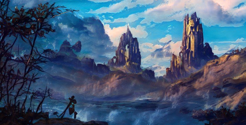
Helderoth's Rift
This ravine is located south of the Village of Oakhurst and The Ashen Plain, at the southernmost point of the Old Road. Historians say that it was created as a result of an epic battle between the Great Wyrm Ashardalon and the human king Helderoth the Bold. It is rumored that the depths of Helderoth's Rift contain the [Sunless Citadel.
Geography
This giant crack in the earth is situated at the base of the southern Serpentcoil Mountains. It runs several miles in either direction, with an average depth and width of 30 feet, widening to 40 feet at the point where it most closely intersects with the Old Road. It is there also that the rift plunges deepest into the earth.
The Old Road passes to the east of the narrow ravine. At the roads closest approach to the cleft, several broken pillars jut from the earth where the rift widens and opens into something more akin to a deep but narrow canyon. Two of the pillars stand straight, but most of them lean against the sloped earth. Others are broken, and several have apparently fallen into the darkness-shrouded depths. A few similar pillars are visible on the opposite side of the ravine.
Fauna & Flora
Goblins have long inhabited the fallen fortress contained herein. It is assumed, now that the ancient fortress has been discovered by adventurers, that the goblins originally came up from the Underdark to claim the Sunless Citadel as their own. More recently, a clan of kobolds has taken up residence within. Alongside these two waring sentient species are the various insectile and mammalian vermin one might expect to find living in dark and craggy spaces. These include dire and cave rats, giant spiders, bugbears, and earth elementals.
History
T the crown jewel of King Helderoth's half dozen mountain fortresses was called the Stoneface Stronghold. The benevolent king is said to have ruled over a relatively small but extremely prosperous mountain pass region, then known as the Golden Plains. It was located in the only mountain pass that divided the northern and southern Serpentcoil Mountains.
The Great Wyrm Ashardalon began to expand his territory into the pass, desiring to find a new home for his legendarily massive hoard. The encroachment into the Golden Plains meant much death and destruction for the people of Helderoth's kingdom. The king mounted a massive force to combat the red dragon, and a protracted but extremely bloody war ensued, culminating in the destruction of most of the good king's mountain fortresses.
The final stand of King Helderoth the Bold occurred at his largest and most well-garrisoned citadel, Stoneface Stronghold. After a long aerial assault was mostly repelled, the Great Wyrm changed tactics, choosing instead to bombard the very earth on which the fortress stood. The wyrm's rampage was so long and so fierce that the land first buckled, then opened up and swallowed the entire stronghold.
The current residents of what is now known as Duvik's Pass know very little of the history surrounding this region. They are immigrants from the Sammeliund Empire to the East and populated this mountain pass centuries after the battles between this once great king and the rampaging red dragon were fought and lost. The tales of good king Helderoth's are now only found in the dustiest tomes located in the darkest libraries in the Onyx Lyceum.
Recently, there have been two adventuring parties that have set out to explore the mysterious ravine to the south of Oakhurst. The first is a month overdue to return. The second was sent out to learn of their fate.

Overland Map by Wizards of the Coast
Type
Gorge / Rift
Remove these ads. Join the Worldbuilders Guild


Comments