Zahira Desert
The Zahira is a hot desert Corridor in Southern Sh'hoona. With an area of 1,026,000 square miles, it is the largest known desert in Kriadar and one of the largest Corridors.
The name Zahira is derived loosely from the ancient Halite term for "desert", of which its roots mean "endless heat."
The desert comprises all of southern Sh'hoona, taking up approximately 1/3 of the land in the continent. It stretches from the Yozira Ocean in the west to the Vayrek Ocean in the east. The desert is bound on all sides by mountain ranges. To the north, the Elibar Mountains separate the desert from the rest of Sh'hoona, while to the south the Ered mountains separate it from the land of Mavom. Along the western coast, the Elibar mountains are less pronounced, allowing some rainfall and creating a semi-arid coastal region.
The Zahira can be divided into several regions including the Dahlya Valley, Central Zahira, Kaltina Mountains, Southern Elibar Mountains, Jair Desert, Amani Valley, Vonjair Mountains, and Sadar Desert.
Geography
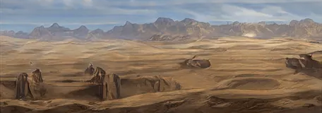
The Zahira desert is a vast region taking up 1/3 of the landmass of Sh'hoona. It covers over 1,026,000 square miles. Being bound by mountains on all sides, the region is predominately closed off from the rest of the continent, it is considered a subcontinent alongside Mavom. The geography of the Zahira desert is predominately made up of rocky stone plateaus, with several sand seas in the central regions moving away from the mountains. Most regions are not known for heavy winds, leading to lower sitting sand dunes while the interior mountains surrounding the region are among the highest in the world. The central sand seas are hyperarid, extremely hot regions with little vegetation. Along the mountains, some small waterfall allows the growth of sparse vegetation. Oases are known to be found mostly on the cusp between the rocky mountainous regions and the sand seas. The Elibar mountains cut into the desert moving towards the southeast. Central Zahira sits between these mountains and the Kaltina Mountains. Central Zahira and the Southern Elibar mountains are among the hottest regions in the world. Rainfall to these regions is completely blocked off from all sides, leading to a desolate hot land. The Jair desert to the southeast of the Southern Elibar mountains is also known for being an arid region, though some waters heading northwest from the Vonjair and Ered does pass through the region and there are quite a few oases. Along the western coast, the Dahlya Valley turns semi-arid, with rains from the Yozira ocean allowing flora and fauna to develop. The western slopes of the Kaltina mountains are one of the wetter regions in the desert, creating a dry summer climate nearer the mountains. The Amani Valley transitions into a semi-arid climate further north and away from the Vonjair mountains. On the valley's side of the Vonjair mountains, little rain passes through. The Sadar Desert is the western counterpart to the Dahlya Valley, albeit with less access to water. This region is believed to have once been a large sea, or even a part of the Vayrek Ocean. The western mountains are especially volatile, with several active volcanoes in the region.Seams
The Zahira desert is unique in that it is one of the largest continuous Corridors, with seams only developing deep within the desert and away from the mountains. Most of these seams are quite small in nature, however the Desert Snake Seam in the Central Zahiran Desert is one of the longest seams in the world. It is generally accepted that the lack of seam division in the Zahira desert implies that it is a single corridor created together. Many scholars believe that the Zahira is one of the original corridors of Kriadar.Climate and Ecology
The various regions of the Zahira Desert all have their own unique ecosystems, some of them containing different distinct ecoregions within their larger region. Dahlya Valley and Kaltina Mountains As a semi-arid region, the Dahlya Valley is the most ecologically diverse region in the Zahira Desert. Moving east to west, the region grows more arid, with the regions beneath the Western Elibar being the driest in the region. Beneath the Kaltina mountains, water that passed over the Elibar is collected, running down the mountains and forming small streams that collect to form the Zahra River, which eventually terminates in the salt sea of Basagir. Along the Zahra River and in the eastern semi-arid regions dry woodlands can be found. These woodlands eventually thin out, turning to shrublands in the west and south. Central Zahira and the Southern Elibar Mountains The hottest regions of the Zahira desert, Central Zahira and its surrounding mountains, including the eastern slopes of the Kaltina Mountains, are sparse and desolate regions. There is little flora or fauna in these regions, mostly characterized by its low sand dunes and salt flats. Along the borders with other regions, especially south of Basagir Sea, some cacti and shrubbery can be found, increasing in density the further away from the hyper arid region. Jair Desert The Jair Desert is less desolate than Central Zahira, with some dry riverbeds that occasionally fill up with water. Along these riverbeds, and in the oases, shrublands have formed and there are many species of cacti. Desert creatures, such as the desert fox, goats and desert owls, are known to reside in this region. Amani Valley The northwestern regions of the Amani Valley, leading up to the Shinalar Pass and Sh'hoona, are semi-arid shrublands. To the east, along the Vonjair mountains, the region is arid with little rain or vegetation. The center of the Amani Valley, close to the Jair Desert, contains many oases and is a diverse region with several woodlands forming around the oases. Vonjair Mountains While the eastern slopes of the Vonjair Mountains are the wellspring of life and the source of the swampy waters of Netviz, the western slopes see almost no rain or water. Less hot than the Jair or Central Zahira, the lack of water still creates a desolate region in the northeast and eastern Amani Valley. Sadar Desert The Sadar Desert is characterized by its dark volcanic soil. In regions of the Sadar desert where there is more rainfall, especially the southwestern slopes of the Ered Mountains, this fertile soil results in a flourishing ecosystem with thick shrublands and even some woodland regions known for its unique flora and fauna. Away from the mountains, the land grows more arid, however these regions as well still have more unique flora in comparison to other similar regions.History
As one of the oldest corridors, the Zahira Desert has a long history of peoples living within its more inhabitable regions. Specifically, the Dahlya and Amani valleys, and the Sadar Desert have all peoples living there throughout history.Anoraith
Archaeological and historical records show that there was once an elven civilization, referred to as the Anoraith or Desert Elves, centered in the Dahlya Valley, starting approximately 25,000 years ago and coinciding with the elven exodus known as the Estekoast and ending with the destruction of the civilization during the period known as the Dagveri. The Anoraith are commonly held to be the elven ancestors of the mixed Halite people. Most scholars believe that the Anoraith no longer exist, having either intermarried with humans to the north or joined their cousins to the south. However, sightings of bronze-skinned desert elves living among the caves and hills of the Kaltina mountains have been reported many times over the centuries. Whether these elves are Halites favoring their elven ancestry, or Mavom elves bearing some Anoraith blood remains a mystery today. It is unknown to what extent the Anoraith civilization spread throughout the Zahiran Desert. The Dahlya Valley is filled with the ruins of their civilization, while other ruins believed to be Anoraith in nature have been found as far as the Sadar Desert.Terakipi
Archaeological expeditions in the Amani Valley and the dry lands north of Shinalar Pass have revealed evidence of human settlements in the region going back to 12,000 years. These peopleDesmean
Type
Desert
Location under
