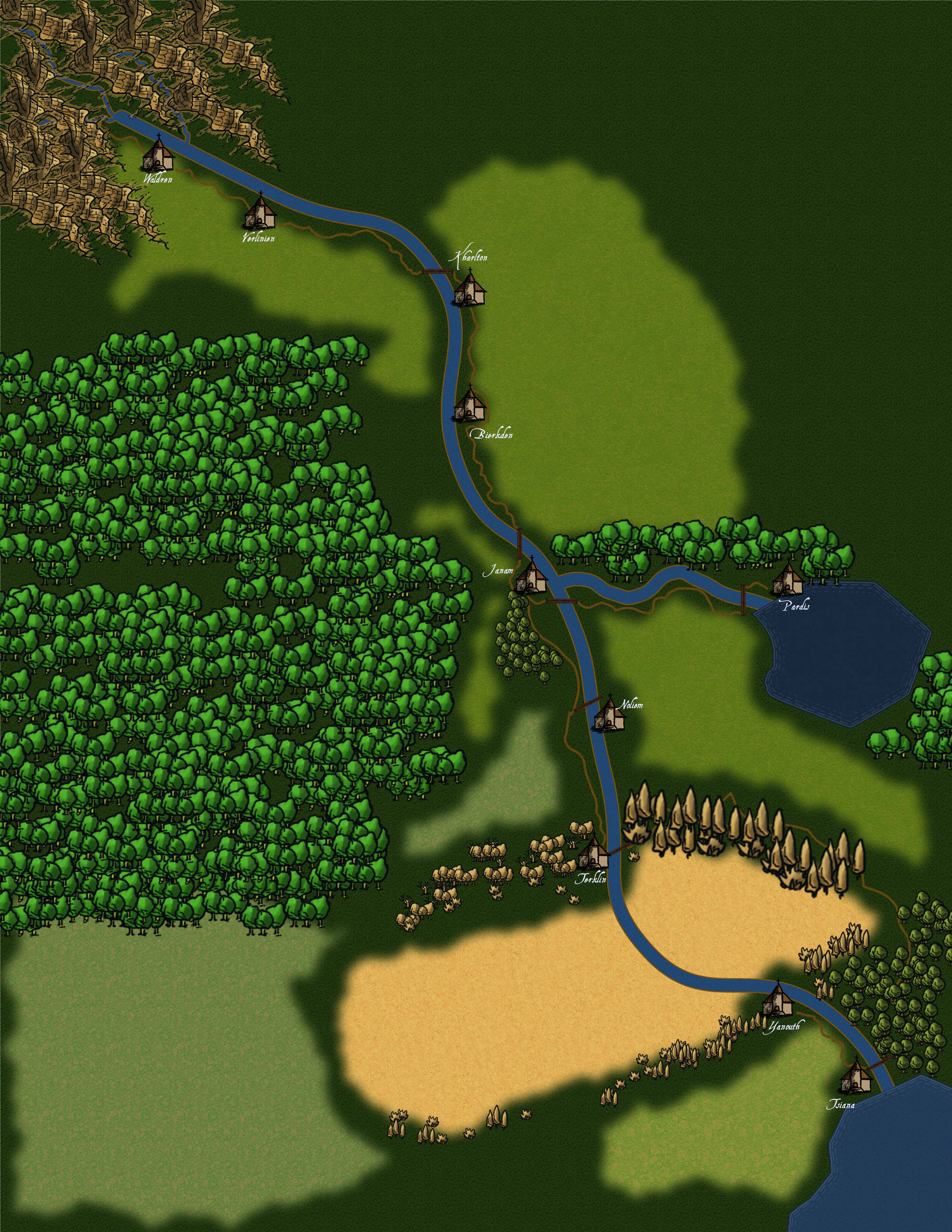
The Mandi River
The Mandi River traverses the eastern portion of the continent Premin from the Ghajaen Mountains in the Northwest to the Gulf of Swemzast in the Southeast. It spawns three tributaries, one heading south from the port settlement of Verlinien, one to the southwest from the port settlement of Janam, and a short one heading northeast from the settlement of Terklin. Each of these settlements are upriver from the tributary branch. There are addtional settlements along the Mandi River. In order from north to south the settlements are Waldren, Kharlton, Verlinien, Bierkden, Noliem, Terklin, Yanouth, and terminating at the Gulf Port Settlement of Tsiana.
Ecosystem
The ecosystem along the river is quite diverse as the river flows from its source to its termination at the Gulf of Swemzast. At Waldren, where winter is well known and frosts and floods are more common, life in and along the river is cold weather tolerant. Robust farmlands and ranches can be found from Kharlton to Noliem. Desert and dustbowl conditions exist between Terklin and Tsiana where the settlement of Yanouth lies. Winds in the northwest flow primarily north to south and blocked by the Ghajaen Mountain Range, slowly shifting to westerly and southwesterly before reaching Tsiana.
Ecosystem Cycles
The settlement of Waldren in the northeast sees the widest variety cycles from warm summers and brutally cold winters to near serene and constant climate through all seacons at the gulf itself. Humidity along the river runs very high through all seasons adding extra bite to the hottest and coldest temperature peaks.
Fauna & Flora
As the river winds its way southeast and the climate warms, the fauna and foliage change. Fir trees give way to redwoods and might oaks to citrus groves. Salmon and turtles yield to snails, mussels, crayfishes, and reptiles such as alligators. A large variety of snakes, both venemous and not, populate the desert and Yanouth.
Natural Resources
| Settlement | Trees | Grains | Vegetables | Industry |
|---|---|---|---|---|
| Waldren | Pine and Maple | Winter Wheat and Rye | Potatoes, Tomatoes, Onions | Logging, farming, crafts |
| Verlinien | Redwoods and Maple | Wheat, Corn, and Rye | Potatoes, Tomatoes, Onions | Logging, farming, crafts |
| Kharlton | Maple, Oak and Hickory | Wheat, Corn, and Rye | Potatoes, Tomatoes, Onions | Logging, farming, crafts |
| Bierkden | Oak and Hickory | Wheat, Corn, and Rye | Potatoes, Tomatoes, Onions | Logging, farming, crafts |
| Janam | Rosewood, Walnut, and Cherry | Wheat and Corn | Potatoes, Tomatoes, Onions | Logging, farming, crafts |
| Noliem | Rosewood and Cherry | Wheat and Corn | Peas, Beans, Peppers | Logging, farming, crafts |
| Terklin | Rosewood, Walnut, and Cherry | Wheat and Corn | Sweet Potatoes, Peas, Beans, Peppers | Logging, farming, crafts |
| Yanouth | various tumbleweeds | Wheat | Sweet Potatoes and Beans | Glass making, crafts |
| Tsiana | All citrus varietals and Bamboo. | Wheat | Sweet Potatoes, Peas, Beans, Peppers | International Trade, diplomacy, |
History
Settlements along the Mandi River were created as Tsiana grew and it needed to find ways to support itself with more locally produced goods and even add exports to its indrusties. The settlements were founded to support the growth and expansion of population and industry in Tsiana to access to the discovered resources in the following order:
- Tsiana was the landing point for orignial settlers of the Premin continent.
- Noliem
- Terklin
- Waldren
- Bierkden
- Kharlton
- Janam (near manmade tribuatry leading northeast to Mandlake.)
- Verlinien
- Yanouth privides a waypoint through desert and access to its sand deposits.
Tourism
Janam is a primary tourism stop, mostly due to its access to the resort destination of Pardis located at Mandlake.


Pretty cool use for the table. I can indeed see it is getting hotter near the last settlement :p
Thanks, the table really does consolidate the information to describe the changes along the river route without using a visual map.