Anumit Delta
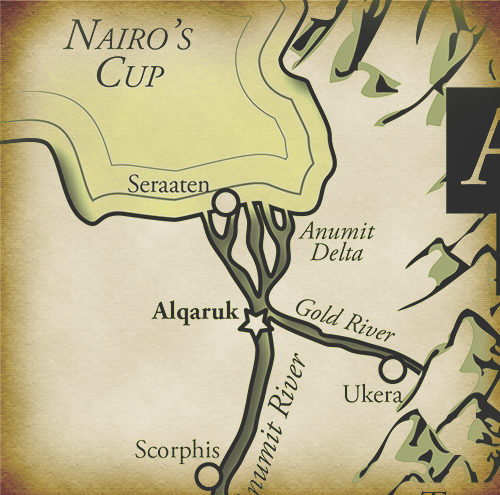
The Anumit Delta is the delta formed in Rashid where the Anumite River spreads out and drains into Nairo’s Cup. It begins just north of Alqaruk.
Contents
1. Annual Flooding2. Geography
3. Flora & Fauna
4. Natural Resources
Annual Flood
The Anumit delta floods annually. This flooding was crucial to the development and survival of the ancient Anumite Empire as it replenished their fields with the nutrients required to grow crops. There are multiple accounts of devastating famines in years when the river flooded less than average or did not flood at all.
There were three major seasons based around the flooding:
Summer/Inundation
The Anumit river would flood all summer, beginning just before the summer solstice. During that time, the Anumites made tools, looked after their animals, and worked on building monuments. Some scholars believe that this is the way the great River Temple was constructed, although Rashidi scholars hold that the Anumites used Rashidi slaves to build it.
The River Festival, the most elaborate of all the ancient Anumite celebrations, took place during the start of summer. They believed that the River Goddess, Ankti, controlled the flood waters, so the festival was held in her honor.
Autumn/Growing
Around the autumnal equinox the waters would begin to recede and the Anumites would begin ploughing the fields and sowing seeds.
Spring/Harvest
Before the river could flood again, the Anumites would harvest their crops.
Geography
From west to east, the delta covers approximately 160 miles. From north to south, it is 120 miles across.
The delta consists of three major distributaries. There is some evidence that the eastern most distributary was man-made, but it is not conclusive. Such a feat would indicate that the ancient Anumites were more advanced than previously thought.
While the lower parts of the Anumit River are quite rocky and difficult to navigate in places, the river (and delta) north of Alqaruk is easily navigable, especially during the summer when the delta is at it’s highest levels.
The two major cities located in the Anumit Delta are Alqaruk and Seraaten. Seraaten is the older of the two due to it’s proximity to the salt lakes and abundance of fish in Nairo’s Cup, but Alqaruk quickly overtook it as the most populous city in the empire when trade between the upper and lower kingdoms increased. Alqaruk’s position at the top of the delta just after the last cataract gave the city control over trade. Both served as the capital of the Anumite Empire at various times (once even simultaneously).
Fauna & Flora
Common crops in the Anumit Delta included: wheat, barley, flax, onions, leeks, garlic, beans, lettuce, lentils, cabbages, radishes, turnips, grapes, figs, plums, and melons.
Wheat was used for bread, barley for beer, and flax for linen.
Papyrus growing along the banks of the Anumit River were used for sandals, boats, baskets, mats, and paper.
The Anumites kept domesticated cattle, goats, sheep, pigs, ducks, and oxen.
Crocodiles, hippopotamuses, and tortoises were also common.
Natural Resources
Salt was a key resource in the delta. The numerous saline lakes shores were often crusted with dried salt, which made it very easy to harvest. The Anumites used their salt to preserve food and create abundant food stores to mitigate the risk of the Anumit river not flooding.
Remove these ads. Join the Worldbuilders Guild


Comments