The city of Lyon
Table of Contents
The magnificent city of Lyon! Filled with flooding rivers, mosquito-filled swamps, silk manufactures, a royal palace, and best of all: us!
— Sergeant 
History
Foundation
Lyon is an ancient French city located near the Eastern border ofthe country, at the meeting of two important rivers, the Saône and the Rhône, and two steep hills, the Croix-Rousse (Red-Cross) and Fourvière. A peninsula, Canabae, is also found at the meeting of the two rivers. Funded in 43 BC by the Roman Lucius Munatius Plancus, Lugdunnum was the capital of one the three Roman provinces making up Gaule, Gallia Lugdunensis. It was said to be the biggest city West of Italy. Lugdunum was founded on the right bank of the Saône, on part of the Fourvière hill thanks to an aqueduct bringing water to it. The city grew very quickly and swallowed the older Gallic bourg of Condate (possibly dating from the 9th or 8th century BC) located at the foot of the Croix-Rousse hill, and spread over Canabae and, after the aqueduct technology progressed enought to allow it, up to the top of the hill of Fourvière.After the fall of the Roman Empire
From the fall of the Roman empire, the city went through several periods of development and stagnation, and part of the Roman city was abandoned because of the failure of the aqueducts. However, the location of the city was too strategical for it to stay forgotten for long, at the heart of the border region between the Kingdom of France, the Holy Roman Empire and the Papal States. In the end, royal favour allowed the city to have international fairs and the development of the silk industry gave back to the city its prominence. At least until the revolution of 1789 which entirely devastated the city and made at least 20,000 deaths. On official register in 1804, it counted only 94,000 inhabitants. Fifty years have gone by since then, and the city is slowly recovering, once again thanks to silk. Demographic growth is fast, with already 121,000 inhabitants in 1812 and now 241,000 in 1846, and the urbanisation of the city has to keep up the pace. This is a time of changes.
Lugdunum at its foundation by Ruthven on Wikimedia Commons
Things got so bad under the revolution that the new governemnt decided that Lyon should not be allowed to use its own name anymore and should be called Ville-affranchie instead! "Lyon made war to freedom, Lyon is no more"...
— Sergeant
Lyon since the revolution
An inhospitable place
Before the revolution, Lyon was not regarded as a particularly hospitable city. Indeed, the hills are steep and the ground unstable, limiting the ground that can be used for construction. In addition, the two rivers were not controlled and the Rhône regularly flooded the surrounding lands. It was so unpredictable that only two bridges had been able to be built accross it, while the Saône had 5 bridges at the beginning of he century, all with a toll of course. Ferrymen still carried lots of people and goods cross the rivers. Since then, a lot more new bridges have been built, but they keep getting destroyed when the rivers swell with the melting of ice in spring.
Since the failure of the Roman aqueduct, the old Roman city on top of the Fourvière hill had been abandoned. Its buildings were used as a stone quarry, leaving the whole area in unstable ruin. In addition, the Southern part of the peninsula was still a swamp filled with mosquitoes.
During the revolution itself, Lyon rebelled against the new government and it had to be besieged in 1793. As a result, the city was badly damaged. However, thanks to the nationalisation of all of the goods and lands belonging to the Church new areas were opened to construction after the previous buildings were razed. Thus, the beginning of the 19th century has seen a flurry of building projects transform the city of Lyon in an attempt to make it the equal of Paris.
Don't bother going even slightly outside of the main roads, the area is all filled with mosquitoes!
— Sergeant
Royal links
King Lucien has established a fortification belt all around the city in 1831 so as to defend it against foreign powers, in particular the Austrians. The physical protection represented by this is minimal, in some places being little more than an earthen parapet with water-filled ditches. Yet Lucien was one of the most talented warder that the engineering corps had seen in the last few centuries, and he was often garrisoned in Lyon. He has used this time well to establish detailed warding plan for the city and to start implementing them. Those new wards were proved to be very effective when he had the occasion of saving the city from a near disaster due to an uncontrolled alchemical reaction in the military manufacture. Once the Southern part of the peninsula was ready for construction, King Napoléon decided to have a royal palace built there. The project started in 1810 but it was stopped in 1813 because of the war. It restarted in 1817 under Louis XVIII, only to be finished in 1835 under King Lucien. It is now one of his frequent residence. This gives him the occasion to come back to the city often, and each time he has continued to further enhance the wards of the city.His Majesty often honours us with his presence in the city without any warning. That means that he'll come again to inspect us so, you better keep your uniform and barracks constantly in good order! Otherwise—leeches!
— Sergeant
Reorganisation of the city
Starting from 1810, plans were made and construction started to align the house, redo them with beautiful façades, and widen the streets just as Baron Haussmann is doing in Paris. The goal is to make the city more beautiful and prestigious, but also more secure by avoiding small, dark alleys and preventing the inhabitants from building barricades during the next revolution. The persons responsible for those transformation are the engineer Gustave Bonnet, a graduate of the Polytechnique military school, and the architect Benoit Poncet. New bridges are being built accord the rivers, however all of them still have tolls: for example 5 cents to use the bridge Morand. On the administrative side, the neighbourhoods are beeing given new limitations and everything is being renamed after important individuals, from the revolution notably (for example the bridge Lafayette).The new fancy bridges are all scams! Those thieves think they can get us to pay the tolls too when we're the ones who helped them rebuild them after the last floods! See if we bother lifting our little finger next time this happens!
We're still petitioning His Majesty to be exempt from the tolls, but in the meantime we're avoiding all of those new bridges out of spite!
— Sergeant
The Croix Rousse neighbourhood
The Croix Rousse hill was previously covered with ecclesiastic buildings. In the 1830s, they were all replaced with new buildings with high ceilings (4 m) so that they could welcome the new Jacquard machines of the silk workers, leading almost all of them to emigrate there from the Vieux Lyon (Old Lyon, the neighbourhood at the foot of the Fourvière hill where Lugdunum was first founded). All houses are very similar, with workshops with big windows on the ground floor and living apartments in the upper floors. All the houses are pierced with traboules, an architectural feature typical of Lyon: narrow pathways that cross through the courtyards of all the houses until they reach the river. This allows everyone to access the bank easily and the silk workers are also able to carry their silk while protected from the rain.They used to call this place the hill that prays. Now we've made it into the hill that works!
— Sergeant
The left bank of the Rhône
The left bank of the Rhône had been left relatively empty because of the troubles in crossing the river. Right next to the rivers, there are only small fishermen's houses and drinking houses, while beyond it there are a few small castles standing there for the defence of the city. Since 1825, a flurry of building projects has taken place here, in the new neighbourhood of the Brotteaux and Guillotière next to the river, and Monplaisir next to the castles. Big and small bourgeoise houses are being built and several industries implanted. However, the neighbourhoods are highly criticised for the houses being too similar and the roads too straight and without variations, making it very confusing to travel. In addition, the area is still regularly flooded by the Rhône, with one particular event even shifting the course of the river completely in 1754. Dikes have been built since then, but a lot of work is still left to do to control the river.That's where we have our barracks and alchemy manufactures. The idea was that if something went out of control we could not kill too many people thanks to being outside of the city. But of course most people have zero understanding of safety areas... The Colonel is always complaining, but I'm sure you'll appreciate having all the right establishments conveniently nearby!
— Sergeant
Railway
The first railway of the European continent was built in 1817 between Lyon and Saint-Étienne, alongside the first train station of Lyon, the gare du Bourbonnais. Since then, a new Paris-Lyon-Marseille line has been built alongside a new train station, the gare Perrache.They've replaced the horses with coal locomotives now. Once again the French are pioneers! You'll see, the train is very exciting, it goes so fast on the way down we've add more than a few injuries with people falling out after leaning out of the windows!
— Sergeant
New neighbourhoods
With all those changes, the inhabitants are moving around to different neighbourhood. The Peninsula just North of the royal palace, called the neighbourhood of Ainay, is favoured by the nobility, with the rue Mercier being filled with shops. In Brotteaux on the left bank of the Rhône are by the bankers, traders and manufacturers, in the Croix Rousse the silk workers, while in the Guillotière there are other workers and industries, including the military alchemical manufacture. Vaise, on the over bank of the Saône opposite of the Croix-Rousse has also recently been attached to Lyon, and some new industries are emigrating there. The Vieux Lyon at the foot of the Fourvière hill is made of three neighbourhood, from North to South: Saint-Paul, Saint-Jean and Saint-Georges. Despite it being where the cathedral is located, they are filled with old buildings from the Middle Age and Renaissance and occupied by the poor and fishermen. Atop of those neighbourhoods, the Fourvière hill is filled with fields, gardens and big, religious properties, with a church on the top of the hill.Don't go to the Vieux Lyon if you want anything of quality. Even the prostitutes there are better avoided if you like your good health...
— Sergeant

An angry mosquito by Alvesgaspar on Wikimedia commons

Plans of the royal palace built on the peninsula of Lyon by AmélieIS with an image from Wikimedia Commons

New administrative map of Lyon by AmélieIS
Fortification lines: in red.
Official neighbourhood (in black; many are far from being fully urbanised): 1) North of the peninsula and slopes of the Croix-Rousse, 2) peninsula and royal palace, 3) Guillotière-Nord, 4) Croix-Rousse, 5) Vieux Lyon (Saint-Paul, Saint-Jean and Saint-Georges) and Fourvière, 6) Les Brotteaux, 7) Guillotière-Sud, 8) Monplaisir, 9) Vaise.
Bridges (blue) on the Saône: 1) bridge of the Île de barbe (1827), 2) footbridge de Vaise (1831), 3) Serin (1749), 4) Saint-Vincent (1637), 5) bridge la Feuillée (1831), 6) bridge du Change (1070), 7) footbridge du Palais-de-Justice (1638), 8) Bridge Bonaparte (1642), 9) bridge d'Ainay (1749).
Bridges (blue) on the Rhône: 1) bridge Morand (1774), 2) footbridge du College (1845), 3) bridge Lafayette (1826), 4) bridge de l'Hôtel-Dieu (1839), 5) bridge de la Guillotière (Middle Age).

Lyon observed from the hill of La Croix Rousse by Wikimedia Commons

One of the small castle on the left bank of the Rhône by Wikimedia Commons

Gare Bourbonnais by Wikimedia Commons
")
The first trains in Lyon (passengers, goods, coal with horses or with locomotive) by Wikimedia Commons

The neighbourhood of Saint-Georges in the Vieux Lyon by Wikimedia Commons

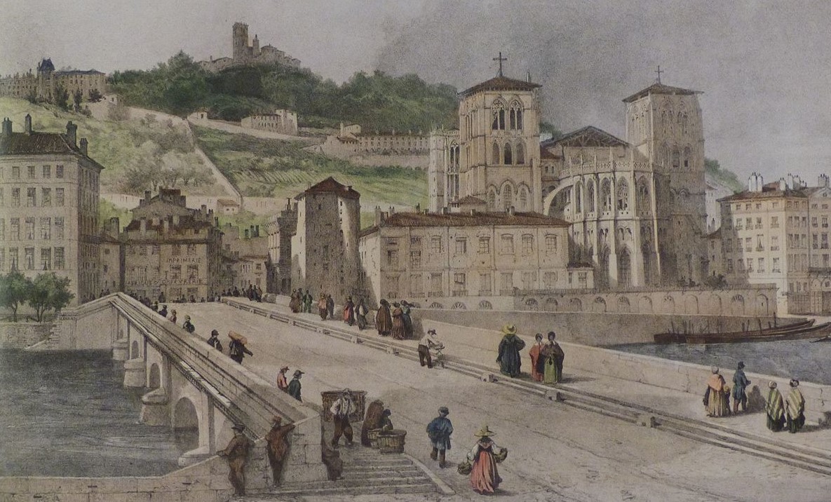
Saint-Jean neighbourhood with its cathedral in the Vieux Lyon by Wikimedia Commons

Brotteaux neighbourhood at the start of the urbanisation in the early 1830s by Wikimedia Commons

Comments
Author's Notes
SourcesLe Plateau du 5e arrondissement et les quartiers historiques de la rive droite de la Saône à Lyon. Etude de géographie et d'aménagement urbain by Jean Pelletier in Géocarrefour (1963 ) 38:11-31.