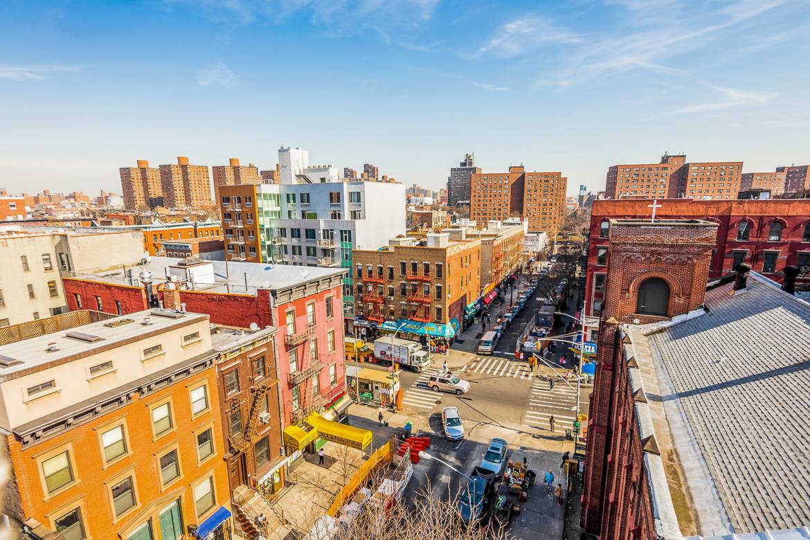
Harlem, Manhattan
a neighborhood in the northern section of the New York City borough of Manhattan. It is bounded roughly by Frederick Douglass Boulevard, St. Nicholas Avenue, and Morningside Park on the west; the Harlem River and 155th Street on the north; Fifth Avenue on the east; and Central Park North on the south. The greater Harlem area encompasses several other neighborhoods and extends west to the Hudson River, north to 155th Street, east to the East River, and south to Martin Luther King, Jr., Boulevard, Central Park, and East 96th Street.
Originally a Dutch village, formally organized in 1658, it is named after the city of Haarlem in the Netherlands. Harlem's history has been defined by a series of economic boom-and-bust cycles, with significant population shifts accompanying each cycle. Harlem was predominantly occupied by Jewish and Italian Americans in the 19th century, but African-American residents began to arrive in large numbers during the Great Migration in the 20th century. In the 1920s and 1930s, Central and West Harlem were the center of the Harlem Renaissance, a major African-American cultural movement. With job losses during the Great Depression of the 1930s and the deindustrialization of New York City after World War II, rates of crime and poverty increased significantly. In the 21st century, crime rates decreased significantly, and Harlem started to gentrify.
Central Harlem is part of Manhattan Community District 10. It is patrolled by the 28th and 32nd Precincts of the New York City Police Department. The greater Harlem area also includes Manhattan Community Districts 9 and 11, and several additional police precincts. Fire services are provided by four New York City Fire Department companies. Politically, Harlem is represented by the New York City Council's 7th, 8th, and 9th districts. The area is served by the New York City Subway and local bus routes. It contains several public elementary, middle, and high schools, and is close to several colleges including Columbia University and the City College of New York.
Population: 116,345
ZIP Codes: 10026–10027, 10030, 10037, 10039
Area codes: 212, 332, 646, and 917
Geography
Harlem is located in Upper Manhattan, often referred to as Uptown by locals. The three neighborhoods comprising the greater Harlem area stretch from the Harlem River and East River to the east, to the Hudson River to the west; and between 155th Street in the north, where it meets Washington Heights, and an uneven boundary along the south that runs along 96th Street east of Fifth Avenue, 110th Street between Fifth Avenue to Morningside Park, and 125th Street west of Morningside Park to the Hudson River. These boundaries are also cited by Encyclopædia Britannica, though the Encyclopedia of New York City takes a much more conservative view of Harlem's boundaries, only regarding central Harlem as part of Harlem proper.:573
Central Harlem is the name of Harlem proper, and it falls under Manhattan Community District 10. This section is bounded by Fifth Avenue on the east; Central Park on the south; Morningside Park, St. Nicholas Avenue and Edgecombe Avenue on the west; and the Harlem River on the north. A chain of three large linear parks—Morningside Park, St. Nicholas Park and Jackie Robinson Park—are situated on steeply rising banks and form most of the district's western boundary. Fifth Avenue, as well as Marcus Garvey Park (also known as Mount Morris Park), separate this area from East Harlem to the east. Central Harlem includes the Mount Morris Park Historic District.
West Harlem is composed of Manhattanville and Hamilton Heights, which collectively comprise Manhattan Community District 9 and are not part of Harlem proper. The two neighborhoods' area is bounded by Cathedral Parkway/110th Street on the south; 155th Street on the north; Manhattan/Morningside Ave/St. Nicholas/Bradhurst/Edgecombe Avenues on the east; and Riverside Park/the Hudson River on the west. Manhattanville begins at roughly 123rd Street and extends northward to 135th Street. The northernmost section of West Harlem is Hamilton Heights.
East Harlem, also called Spanish Harlem or El Barrio, is located within Manhattan Community District 11, which is bounded by East 96th Street on the south, East 138th Street on the north, Fifth Avenue on the west, and the Harlem River on the east. It is not part of Harlem proper.
SoHa controversy
Further information: Morningside Heights, Manhattan § SoHa controversy
In the 2010s, some real estate professionals started rebranding south Harlem and Morningside Heights as "SoHa" (a name standing for "South Harlem" in the style of SoHo or NoHo) in an attempt to accelerate gentrification of the neighborhoods. This was generally taken negatively by the community, and is not in common use as a name today. New York City politicians have initiated legislative efforts to curtail this practice of neighborhood rebranding.[16]
Political representation
Politically, central Harlem is in New York's 13th congressional district. It is in the New York State Senate's 30th district, the New York State Assembly's 68th and 70th districts, and the New York City Council's 7th, 8th, and 9th districts.
Included Locations
Characters in Location
Remove these ads. Join the Worldbuilders Guild


Comments