Imaginarium 2022 - View from Above
How might satellites, aerial photography, or a view from above affect your world?
Today, I get to share a blast from my past. A couple decades ago, I had the privilege of working on the Landsat-7 project, a NASA contract. I loved seeing new pictures of the Earth, especially since it was a view few saw, even though it was public access. It made me feel like I was in the James Bond movies.

Landsat 7 (via NASA)
View From Above
Satellite data and aerial photography are great for showing change, whether that be over decades (like the Amazonian deforestation) or right after a tsunami. You can use it to predict storms and study forest fires, provide military intelligence, or track the emerald ash borer beetle's decimation of ash trees across the United States.How Can We Use it in Our Settings?
Usable Imagery
Images created by NASA and the USGS are public domain. Ensure a government entity created it. Just because an image is on a government site, doesn't mean it's fair game. And even though an image is in public domain, WA events require image credits for competitions. So credit the creator (person or device) and note the government entity or 'Public Domain'.Some of my favorite sets are Earth as Art, NASA Image of the Day, and Image of the Week Galleries. I was around for the first Earth as Art set and have a print of the Lena River Delta image.
Tracking Change and Patterns
In the 'real world' we can show change over time or after a large incident. Here are some examples.
by Landsat 7 (NASA)

by Landsat 8 (NASA)
Using Satellite Data as Inspiration
How might you show important changes and patterns in your world?
Images can tell so many stories. Let your imagination go wild. Let's peek at our camp themes for 2022 and brainstorm a bit to get you started.Worldbuilding Note
You don't have to have a high-tech world to use the ideas here. In the age of hot air balloons and zephyrs, they could use the view to draw a better map or scout enemy positions. So you could have scouts on wingback or use the view from a sky-high spire.
by MODIS Rapid Response Team at NASA GSFC
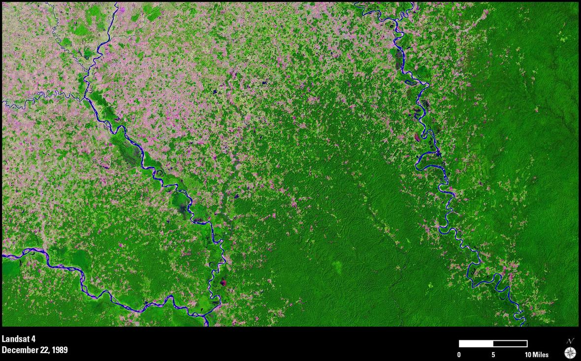
(This may be best shown on a local level for the most impact. The image comparison statblock TJ Trewin created is awesome for this. Drag the little white triangle at the bottom left to move the comparision slider. Images from USGS Amazon deforestation research.)

Or what if a huge windstorm swept through a farming county? The wind damage would be uneven throughout the area. What might it look like? Would the locals blame the winds on supernatural judgement when someone studying the weather could reassure the farmers it was just wind gusts?
Learning About Our World for Worldbuilding
Do you need to understand how an aspect of the real world works for your own creations? NASA and the USGS are great resources. How do islands affect the clouds? Sometimes the effect can be spectacular. Below is an island sticking up out of the water and caused vortices in the low clouds.
by Landsat 7 (NASA)

by Landsat 8 (NASA)
Did you enjoy the pretty pictures? I hope that a different perspective will inspire you for Summer Camp!
How will you use satellite data, aerial photography, or a view from above in your world?
Tell us about yourself
*Waves to everyone* Hi! I'm Amy Winters-Voss, aka Shyredfox.


Comments