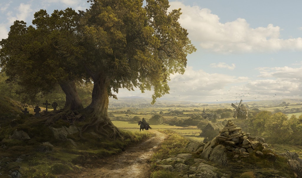
Erub: A Major Continent
Erub is a western continent currently dominated by the imperial political entity of Juraedon. Discounting the various factional tribes that claim independence, such as the Blue Dwarf enclaves, the continent of Erub is, for the most part, ruled by the Emperor of Juraedon. To the south are some territories owned by the Empire of Kilae, and the Island of Tete is ruled by the Kingdom of Tete.
Name
The conception of Erub as a distinct division of the earth, separate from the continent of Tizüb, had its origin in ancient times. The sailors of the Archine Sea applied the Elvish designation Erub and Tüb to the countries lying respectively west and east of the sea. In this way it became customary to call the colony Jelum and all that lay behind it Erub while Uulsan Torall and the parts beyond were called Tizüb. At a later date the mass of land beyond the Isthmus of Isim would be set off as a distinct division of the earth with the name of Kular or Aran.
Positions, Boundaries, and Area
Erub is the second largest of the three continents of the known world. In our current understanding, it constitutes a little less than a third of the total dry land in the world. It is united to Tizüb by the Isthmus of Juraedon, and with Aran by the Isthmus of Isim. On the north it is bounded by the Waves of the Mother; on the west, by the Placid Ocean; the Archine Sea separates the continents of Tizüb and Erub; and on the east are the various Islands of Boryen and the vast Bory Ocean.
The separation between the continents has become more apparent as the Twin Canals of the Twin Empires have separated the three continents from each other.
The northernmost point of Erub is the Isle of Mengroe belonging to Juraedon Proper. The westernmost point is the Isle of the Blue in the Western Mountains. The southernmost point is Cape Swabby in the country of Swabby. The easternmost point is the Beart Promontory, on which the City of Juraedon, capital of the Empire of Juraedon, resides. These statements do not include the northern islands of Nova Zerra, Madiera, or Greentown.
The majority of the names in this article are anglicanised (e.g. Florental is called in the local tongue Fla Dahê).

Geography
The physical features of Erub, owing to its immense geographical area, are of great diversity. There we meet the most extensive lowlands, the most extensive plateaus, the longest chains of mountains, and the widest plains in the world. About one-fourth of its area is table-lands and mountainous regions, some of which are covered with perpetual snow. The western regions of Erub are mostly sterile, dominated by the Western Mountains and the Alk'kir Desert. The far-eastern lowlands of Lower Huraedon are of great productivity and fertility. But perhaps most valuable of all territories are the northern Great Plains of the Kingdom of Seinis in Greater Huraedon.
The rivers of Erub belong to four main drainage systems, namely, the Placid Sea, Lake Erquad, the Archine Sea, and the Bory Ocean. The greatest rivers of Erub offer easy navigation and are important resources to their respective nations. The lakes of Erub are most often in the northern reaches, at or above the latitude of the Great Plains. Lakes also form often within the Western Mountains and occur often in the lowlands of Eastern Lower Huraedon.
Erub is comprised of six great regions. The regions are as such: Huraedon, which composes of Lower Huraedon and Greater Huraedon; Juraedon Proper, which composes of all the regions to the east of the River Pentos and east of the westernmost border of the Mountains of Das EkLachen; Alk'kir, which composes of the entirety of the Mendesian River region and all regions west of the river, all regions north of the Western Mountains, and all regions west of Lake Erquad; the Western Mountains, which composes of all the regions within the Western Plateau; the Southern Marches, which composes of all the nations south of Lower Huraedon, east of the Western Mountains, and bounded to the east by the Bory Ocean and bounded to the west by the Placid Sea; and the Relics of Boryen, which composes of all the islands just beyond the coast of Lower Huraedon, with its westernmost point being the Bay of Turnben located in the Isle of Wishes and its easternmost point being the White Salt-cliffs of the Island of Tete.

Description of Environments
There are many environments in the continent of Erub. These environments are designated as regions or territories and are listed under the six great regions of Erub. The population, climate, and natural environment are described.
Huraedon
This is a peaceful and green land. Flat near the coast, rolling hills to the west, highly populated, and the weather is unpredictable and changeable the nearer you are to the coast.
This region is a dense massif, highland, and plateau region, part of the Great Western Range which stretches from Yakughst up to the northernmost reaches of the Small Dwarf Hills. The region is filled with tall, green hills; sheer crags; stony reliefs, carved in the various figures of famous Dwarfen figures of Pokhrazad; and dotted with vast caverns that lead to either hidden hoards or are warm hideaways from the chilling and snowy winters that descend on this region. There are few people who live above ground, and the local Dwarfs dislike loiterers. The underground kingdom of Pokhrazad is quite densely populous. The various Gnome Click-cities to the north of this region are likewise densely populated. The region is densely forested, so long as the woods are not near a Dwarfen door. The weather is even and predictable so long as you are not near the Western Mountains. Rain occurs quite often in the eastern areas, but the region is quite dry in the west until springtime, when the winter rivers flood the area.
Greater Huraedon
This region is filled with hills and dense coniferous trees and pine trees. The region is composed of a taiga environment and very few people live here. If there are farms, they are small, and villages never break more than a few dozen people in terms of population. The soil is extremely poor; the weather is even but there are many storms. Winter is deadly cold.
This region is very hilly with short hills and dense forests. The population is sparse the more inland you go but overall the region is sparse nonetheless. There are many goblin and orc tribes that hide here. Villages are tucked between the various valleys; the soil is poor. Wherever villages are, are fewer trees as they need wood for mining operations. This place is extraordinarily cold especially in winter. The weather is calm and predictable but occasional blizzards occur up north.
This region is very hilly and is filled with dense and dangerous forests. The population is sparse and hardy throughout the vale, and most villagers are based around the many waterfall-blacksmiths that live here and the incoming trade. The soil is poor or the river floods too violently to have consistent farming. There are many barbaric tribes in this region, preying on unwary travelers. This region is a wildland between the safety of the villages.
This is a country of olive garths and oranges. It has temperate and warm temperatures nearer to the coast. The population is moderately dense; morseso by the coast. The region is moderately wooded with moderate hills that grow in intensity nearer to the Vale of the Sein. Villages are mostly nestled between hills that grow oranges or olives. Sparse population geographic wise but when there are villages they are relatively large. There is a high population density along the coast, and the weather is unpredictable and changeable.
A vine country and region of berries; very hilly, with dense and tall hills. The land is heavily wooded, barring the vineyard land, the soil is rich due to the many nearby volcanoes, and villages and farms are sparse. The vineyard villages attract dense populations. The west is hot due to oncoming desert air from Alk'kir and is an unpopulated and overgrown region. The east has the majority of the population. The lands are decentralized, the weather is violent the nearer to the mountains, but is more even-handed in the central areas.
A heavily populated region. Farms cover nearly all the land and there are few virgin forests. The villages are separated by small and controlled woods but otherwise are largely connected by the interlaying farms. There are a few rolling hills with farms on the hill crests. Towards the east is a grain country that rivals Alk'kir's production; at the south is the Old Frontier, which is a long line of fortresses surrounded by farms that have sprouted around them; the weather is even and predictable.
The Birin Promontories is a region famed for its foggy massifs and vast bocages. The coast is very indented, with many rias, cliffs, and capes. It is a long-inhabited territory and was once split between many feuding Kelpie tribes. The people here have a distinct culture from that of the Aleriez people, and much conflict comes between the Birin and their overlords.
Lower Huraedon
This region is relatively flat and filled with a moderate amount of forests. It is highly populated. Farms fill the flat land and the people are well off. Villages are cupped between moderately dense forests or lay by the highway or the highway's branching roads. The weather is changeable and unpredictable, especially along the coast. There are many bogs and marshes dotting the landscape. The northern 1/4th of Eastern Lower Huraedon gets snow. The rest of the region merely gets quite cold during the winter and get lots of rain.
This region is moderately hilly, is very densely wooded, and doesn't have a dense population. Farms lay in valleys between hills or between thick uncut woods. People are hard to find when not along the highway. The weather is calm and mild, especially in the south. Warm summers, dry or wet winters according to how near the sea you are. Some bogs and marshes exist but these are mostly in the east. The region gets cold in the winter but the southern half doesn't get snow. The land is, in many places, sterile or unfit for a great amount of agriculture. Herding is a more common trade.
This region is very hilly, indeed, it is almost mountainous. There is little woodland due to the local mining industry. The region is sparsely populated across its broad geography but population centers tend to be large. Villages lay in fertile valleys between the hills. The largest cities are on the few flatlands that exist. The weather can be violent and unpredictable due to the Storm Giants in the Western Mountains. The flatlands remain well watered and fertile due to the many streams that flow from the Western Mountains and its foothills. The northern 3/4ths of Western Lower Huraedon gets snow due to its verticality.

The Southern Marches
This is a fertile region set between the surrounding mountains and hills of Central Huraedon and the Southern Marches. It is densely populated and is filled with a moderate amount of woods. Farms are everywhere across this entirely flat land. Woods surround large farming complexes but the woods near the coast are depleted. The weather is calm but humid and wet.
Part of the Great Western Range, this region is very hilly; almost mountainous. It is heavily wooded, sparsely populated, and the population centers are small except for the capitals of the nations therein. Villages lay in valleys between the hills, and the weather is oftentimes stormy and wet. The land is well watered and fertile in the farmable territories because of the many alluvial streams that flow from the Western Mountains and their foothills. Summers are hot due to location, and the winters are quite cold, but no snow falls.
This region is very hilly along the coast and the border against the Western Mountains, but the center is a large, flat, and arid plateau. The region as a whole is sparsely populated, and villages are either in valleys to the north or exist on the plateau equally spaced from each other. The region, in general, is heavily wooded, shrubby, and the villages are cupped between small shrubs and woods. To the east are the Frankonian mountains. The weather is dry with little rain due to the elevation. Sometimes in June, July, and August the far western coast will experience rising humidity and heavy storms.
The region is violently hilly throughout except by the coast, which contains many cities. Villages can also lay in the valleys. Overall the region is heavily wooded, the weather is dry and often hot and arid in the inner country and is wet by the coast. During the months in June, July, and August, there is a monsoon season.
A hot and flat land with moderate hills. Frankonia dominates this region. Villages are mostly built on flat tablelands by the road or between the thick forests. The region is newly colonized and is overall heavily wooded. To the west is a mountain range and in the centre is a mountainous region as well. The weather depends on the winds from either the east or the west. The weather is either changeable or even for a week or so and can be arid or wet, though usually arid. It is a hot, almost jungle-like region.
A moderately hilly region with few forests due to the local shipping industry. Villages are either in valleys or on the flat lands near the coast. The weather is calm but humid and wet, just like most regions near the southern Relics of Boryen. The heat is bearable.
A tropical region of palm trees and sand. It is jungle like and very hot. It is humid and wet and has stormy weather during the summer, while winters have dry and predictable weather patterns.
A fertile land with few hills. Villages and farms dominate the main river branch and hills are heavily wooded and unpopulated. The weather is even and humid. This region is cool compared to its neighboring regions, but is still quite warm.
A vast, flat, and arid desert set upon a large tableland at about 6,000 ft. elevation that stretches from coast to coast of the southern marches. People mostly reside beside the large and fertile Elden Waters lake. There are desert cities that stand over groundwater basins. This is a terribly hot region. The western coastal regions are modestly arable, the rains from the Placid Sea relieving the desert heat, but the eastern regions are coastal deserts. This desert is only second in size in Erub to the Alk'kir Desert. The desert halts at the northern hills of Kilae Proper.

Juraedon Proper
A protrusion off of the Peninsula of Pelican, the Archine Penninsula is a hilly region and is populated by mostly fishermen and herders. The region has been heavily deforested to supply the ever-growing shipping trade. It is a cool and wet region. The sea is often stormy and so is the weather. It rains often and it rains hard. Winters are cold and snow occurs. By far the largest city here is that of Archine.
The Penninsula of Pelican is dominated by the Hopper Mountains running through its centre. The peninsula is otherwise a hilly land with little arable land. The coast is laced with many inlets and rills and dotted with many coves and hidden places that disappear and reappear with the tide. Villages are mostly along the coast, dug into the many valleys of the peninsula. It is quite cool. It rains often. The winters are quite cold.
The Eastern Vale of the Sein is very hilly with dense and dangerous forests. The population is sparse and hardy throughout the vale, and most villagers are based around the waterfall blacksmiths and the oncoming trade as the soil is either poor or the river floods too violently to have consistent farming. There are many barbaric tribes in this region, preying on unwary travelers. This region is a wildland between the safety of the villages. It grows quite cold and wet in the winter, and the snow piles on thickly.
Iru-anc Terrain is a geographical unit covering the bulk of Iru-anc, the central region of Juraedon Proper. The coastal areas of Iru-anc are thin strips of flat terrain. For the most part, the Iru-anc Terrain is composed of undulating hilly lands and valleys of modest height. The land is not extraordinarily arable, but villagers are still able to eke out a living acting as fishermen or poor farmers. Snow comes heavy and winter is harsh and wet. There are often storms, and the sea is unpredictable as is the weather.
The Hol flatlands is a protrusion from the Iru-anc Terrain. It is a broad, low-lying area that is both wet and marshy. Many fens cover this region. The land reveals a great amount of fertile wealth when the bogs are drained. The weather is stormy and unpredictable. The winters are hard and wet. There are a great many forests in this region, yet to be cut down. The population is not dense, and you would be hard-pressed to see too many people unless you were traveling along the coast.
The Ovtrelands is the strip of undulating hilly terrain that slowly grows into the Fjalktir highlands. It is bounded by the Archine Sea and the Fjalktir to the north. It is here that the boreal forests of the north begin to appear. Along the coast are plains with residual hills. This region of Juraedon Proper is more densely populated than the rest of Juraedon Proper's hinterland. The coastline is heavily populated by various fisherfolk. The deeper territories are less populated and are filled with sheepherders and goatherders for the most part. The coastline has been slowly drained, and wealthy marshlands have been reclaimed from the sea. The weather is stormy and unpredictable. Summers are mild and warm. Winters are wet and cause great storms and snowfall.
The Fjalktir is a region of highlands. The region is heavily forested, covered by a great boreal forest, and is dotted with igneous extrusions. The region is home to many herders who guide their herds to feast on the darkly green grass. The weather is often rainy and gloomy but is even and predictable. The winters are incredibly harsh and can last a long while.
The northern mountains are characterized by aretes. Towards the north, the mountains slope into fjords. The many rivers that criss-cross this region make for easier travel through the mountainous terrain. The region was once heavily inhabited by Dwarfen clans, although much of this population has since migrated south since the conquests of Juraedon. The region is unpopulated for the most part. Hunter lodges and homesteads are pitstops for would-be travelers. The weather is cold year-round, is rainy, sometimes stormy, but is usually predictable. The air is clear and good for the lungs. There is no real industry in this region.
The golden protrusion is a large region of flat land that juts out from the north-easternmost tip of Erub and ends at the Beart Promontory. It is a well-farmed, densely populated region that has undergone heavy deforestation. The region's weather is unpredictable and often stormy. The people are, for the most part, farmers. During the hard winters the nearby waters begin to freeze over. It is due to magical means that the Elsmere Strait and the Juraedon Canal remains open year round.

Alk'kir
The Jizdan Hills guard the passage of the Mendesian river as it winds down from the Western Mountains. It is an arid region, and few people live here. The weather is even and predictable. The eastern sandstorms of Alk'kir crash against these hills and end abruptly here. Rain is a scarcity, here.
The Mendesian is a winding river of alluvial wealth. It has elevated the eastern reaches of Alk'kir into one of legendary status. With ease, farmers reap great harvests and have an easy life. Luxury crops are grown in abundance. The river is navigated for easy travel and the abundant fish provide fresh meat on a daily basis. While it has violent floods, they are seasonal and are easily planned for. While rain is a scarcity, the region is fertile. Population density is very high. The weather is hot but predictable.
Erzhul Peninsula is a warm region notable for its mild temperature and many salt bogs and marshes that line the coast of Lake Erquad. A large tableland dominates the region's center and is quite arid though still arable. The greatest riches lie along the sinking flatlands and bogs, which can be drained to reveal rich farmlands. This region is quite densely populated along the lake edge but is sparsely populated as you travel inwards or towards the desert. The weather is even and predictable, though dry and there is not too much rain in the central tablelands. Nearer to the coast of the Waves of the Mother and Lake Erquad there are higher levels of precipitation, though it is still less than what a more temperate environment gets.
Piki Peninsula is a hot region jutting from the Alk'kir desert. It is arid and hot and receives little rain. Most of the population lives along the coastal deserts and makes their wealth off of fishing and sheep herding. Population density throughout the territory is low. Cities tend to be modestly large. The weather is even and predictable.
The Grain Coast is a wealthy and hilly region stretching between the Piki Peninsula and the Rastaj Estuary. The region, though hilly, has a great grain industry. The people here live good lives and usually take up a trade in farming or shepherding. The region is also notable for its pottery industry. There is much clay that can be gathered here. The temperature is quite hot and dry, and precipitation is rare unless you are along the fertile coasts. The true reason for the land's fertility is the rich soil in the hills that are gathered by the many rivers and descend to the coast, leaving silt behind to gather and to create rich lands. The region is quite densely populated along the coast, but beyond the mountains lays the desert. The weather is even and predictable.
An ancient and mysterious desert. It is the largest of its kind in the known world. It stretches from the westernmost point of the Kingdom of Alk'kir up to the weaving stream of the Mendesian. It is inhabited by many nomadic tribes, not least among them the Elves of the Alk'kir Desert. It is extremely hot and arid. Salt flats fill the central region. Sandy dunes fill the westernmost regions. Oases dot the landscape, as do wells set by ancient forebearers. Rain never falls, here. It is a dead, and holy, place.

The Western Mountains
Relics of Boryen
The Relics of Boryen are a series of magical isles. They are the remains of the Seven Wars of Hate battled in times long past. Each island has its own unique biome and peoples living therein. These specific regions will not be entreated on in this article. They are long and storied and their specific differences would not be suitable to a mere geographic description.


It is very good.
1 Name
2 Positions, Boundaries, and Area
Maps
-
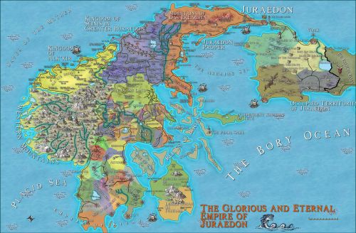
The Glorious and Eternal Empire of Juraedon
The Northern Empire: its territorial extent has never been matched, even by the peerless Nelqorana.

Has the world been so kind to you that you should leave with regret?
Comments