Arbin Watershed
The Arbin Watershed is the colloquial name for the combination of the Arbin Mountains and the Arbin River System, which runs through the continent of Urnimrine. This watershed is the official boundary between the Blivonic Valley and the Tayzem Region.
The Mountains serve to surround the river on all sides. The Arbin River System is split into 3 separate rivers, which join together before emptying out into the Erithorn Ocean. The Arbin, the longest of the three, measures 460 km in length; Moriv runs from the southwest and measures 293 km in length, and Pero, which flows into Arbin from the northeast, measures 320 km.
The Mountains serve to surround the river on all sides. The Arbin River System is split into 3 separate rivers, which join together before emptying out into the Erithorn Ocean. The Arbin, the longest of the three, measures 460 km in length; Moriv runs from the southwest and measures 293 km in length, and Pero, which flows into Arbin from the northeast, measures 320 km.
Geography
Rivers
Arbin
The Arbin River is fed mostly by rainwater, caused by clouds that form over the Arbin Mountains. There are several tributaries that originate in the mountains northwest of the official start, but those only account for 4% of the total water capacity. All of these tributaries group up and flow in between two mountains, called Tiunavir and Dranovir, who signal the beginning of the actual Arbin River. From there it follows the gaps in the mountains, all the way to the coastline. Because the mountains are quite packed together, the average width of the river is only about 4 meters and the average depth is 4 meters.Moriv
Moriv, however, is fed mostly by the Etorma spring, which is hidden deep in the mountains. Because the mountains are not as tall there, they cannot generate enough clouds to sustain the river by themselves. This spring is regarded as the official start of the Moriv River, and to reduce contamination, access to the spring has been restricted to the general public. As it moves away from the spring, the Moriv River will separate into two, three, or even four subrivers before joining back together later. This is due to the region's considerably low mountains, whose shallow bases feature little-to-no height difference on either side. The river's average width is 6 meters, and its average depth is 1 meter.Pero
The Pero River features some of the most varied mountains on the planet, and it is quite common to see peaks right next to each other with up to a 5,000 m difference. It is due to this variation that the Pero River is extremely jagged and winding, and those that sail down this river often do so acknowledging the high risk of crashes and capsizes.Arbin Mountains
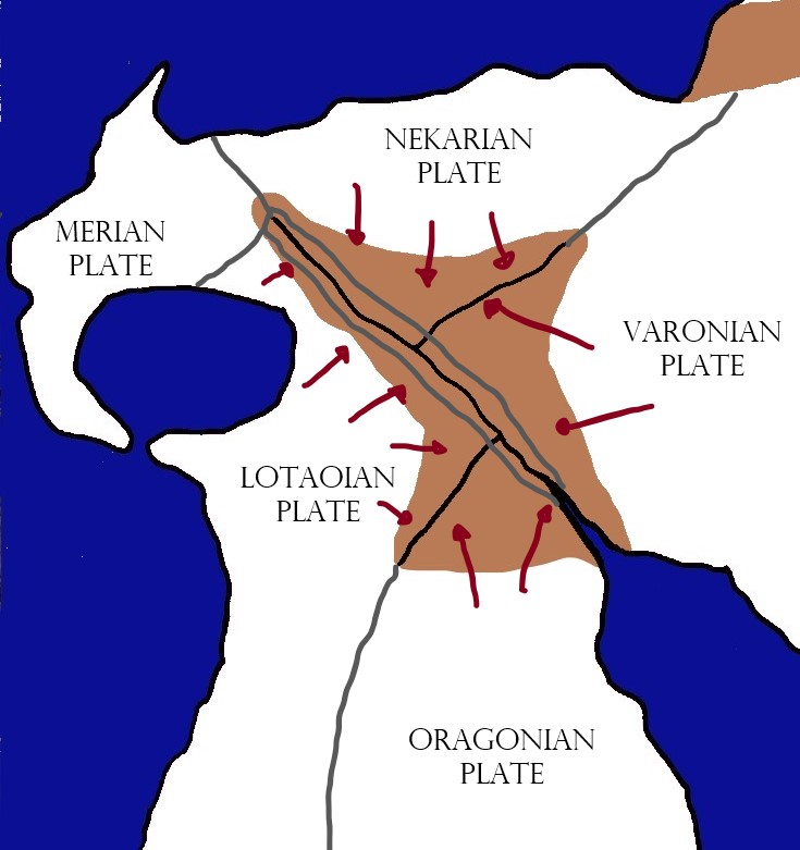
The Arbin Mountains form a cradle around the Rivers, and serve to shape, nurture, and protect them. They are the result of hundreds of millennia of tectonic movement around a geological area called the Arbin Fault System, where the Oragonian, Lotaoian, Nekarian and Varonian plates all push into the tiny Arbin Plate, squishing it from all sides and forming the complex nature of this Watershed. In a few million years, this continued movement will cause the mountains to thicken, which in turn will thin the Rivers and cause them to be completely filled up by the Mountains. This will also completely cut off the Tayzem Region from the Blivonic Valley, restricting any travel between the two regions exclusively to sea.
Type
Mountain Pass
Location under


Those rivers sound hard to navigate, but neat. Is there any money to be made with trade, or is it just for the foolish ones?
Too low they build who build beneath the stars - Edward Young
Because of the mountains and the difficulty they pose in traversing both the winding paths of the rivers as well as the peaks themselves, trade is and has always been nonexistent in both the Arbin and Pero Rivers. However, the Moriv, whose mountains are the lowest of the three, does see some occasional trade, but it has been hampered by the threat posed by the other two.