Minrans {English}
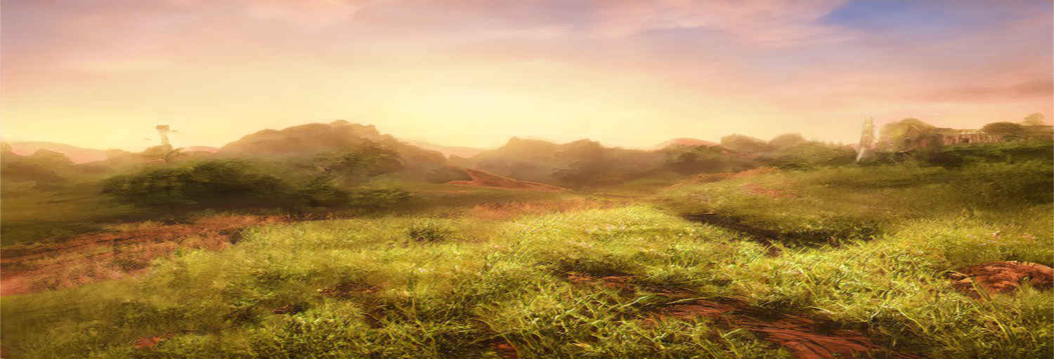
The plains and meadows of Minras shows that even the most beautiful places in the world can fight of the thoughest devestation.There are many places in Telamirein that does have common warfare and have become sickened by it. Then there is Minrans, the middle part of Telamirein where battles have been fought and despite this, it keeps its beauty and balance. Today, most of its plains, meadows, rivers and Lake Merluni is a part of Nilaminra while a small part is still contested by the nation of Telaron. The Berrens runs to the south of Minrans.- Common proverb from Nilaminra
Geography
The geography of the region can be divided into four parts more or less. With the north being mostly the peaceful today and the south having its small-time conflicts, Minrans is still mostly plains with the occasional hills and rivers running to Lake Merluni. Animals roam freely on the most famed plains of Minrans to the west with its occasional small village living in this divided part of Minrans. To the east, the forest of Telamerein extends out and across large distances into the contested territory between Orfordhwelm and Nilaminra.
Just north and connected to Lake Merluni is a small wetlands region. Here in this inhospitable place, there are those how to look for bog iron and tries to make a living as best they can. It is noted however that the marsh hides many things that are not just iron, frogs and grass pods... there are dangerous animals that are out of true fantasy living in these holy lands. And after all, it is restricted to just the inner part of the swamp and the estuary to the lake...
When war has torn these parts, however, the beauty takes its toll under the boots and arms of mankind. Villages burn down and leave room for anew. It is said that ruins can be found underneath that shows that once upon time humanity found their existence in the hands of the Gods here. While no concrete proof has ever been found, legends tell of the battles between demons and humans and that the beauty is a result of the magic showered over the plains.
Lake Merluni is a life-giver of the region, most of the villages, towns and the three cities have some connection to it. It is because of it that the famous plains in the east exist.
The Grey Road runs straight through, creating a highway for traders and merchants that runs between the countries and nations of humanity. It is laid with stone, but in a pattern foreign for all and no one knows who has created the road in the first place.
The north
To the north, are rolling plains mostly. Here, fields of plants grown for the cities and towns for many centuries. This part is known for having been Isvriks part of the lands before Nilaminra was created. Most of the trade carried out between the three cities of Nilaminra goes by Lake Merluni and rivers but the main roads to them are still paved with stone and are patrolled against the wildlife coming from the north and west.Just north and connected to Lake Merluni is a small wetlands region. Here in this inhospitable place, there are those how to look for bog iron and tries to make a living as best they can. It is noted however that the marsh hides many things that are not just iron, frogs and grass pods... there are dangerous animals that are out of true fantasy living in these holy lands. And after all, it is restricted to just the inner part of the swamp and the estuary to the lake...
The west
Plains, plains and more plains, but here, despite war and battles having been fought here many times, they remain beautiful and lush. Small mounds do come up, some said to be graves of dead men and women from the region during the Jorvik age. But the beauty lies in the flower fields and their many colours that are almost fruition year-round. Animals of many kinds roam these parts freely, being owned by the local village or not. It is a place where no predator except the fox and som small wolfs come and hunt so many larger animals are the kings of these plains. The lake close by gives a beautiful shine when standing close by and runs small creeks for animals and villages to use for water and life.When war has torn these parts, however, the beauty takes its toll under the boots and arms of mankind. Villages burn down and leave room for anew. It is said that ruins can be found underneath that shows that once upon time humanity found their existence in the hands of the Gods here. While no concrete proof has ever been found, legends tell of the battles between demons and humans and that the beauty is a result of the magic showered over the plains.
The east
Hills separate Minrans from the Berrens on the southern edge, creating a separation from the Grey Road and the flow of trade. And on the eastern, the Forest of Telamirein has a vast, danger and threat to itself. The eastern part of Minrans is the largest part of all the main three parts that the region can be divided into. Here grasslands are interchanged on the edges by forest and hills. Rivers, both on top and underneath the ground, runs from forests and the mountains. While not the most interesting, it is certainly the most populous one due to having the capital of Astria and many villages living on trade, fishing and smaller croplands.Lake Merluni
In the centre of it all is Lake Merluni, named after the goddess of rivers, water, sea among other things. While many names have existed for the body of water, Lake Merluni is the one that stuck. Fish are plentiful in the lake and a small fishing industry does its business from Relaniia in the east from the outflow of the lake. Lake Merluni is one of the largest lakes in Telamirein and is disputed to be the largest, the other being Forsguun in Orfordhwelm.Lake Merluni is a life-giver of the region, most of the villages, towns and the three cities have some connection to it. It is because of it that the famous plains in the east exist.
The Berrens
The Berrens is not an official part of the region. The name comes from that it is mostly barren with hills and yellow grass around the year and most villages that are built here survive on the trade of mining or dangers of mountain exploration. Many consider the western part belonging to Telaron and the eastern to Orfordhwelm. Over time, however, explorers have found what seems like ruins close to the edge of the mountain chain and close to the intersection for Astria.The Grey Road runs straight through, creating a highway for traders and merchants that runs between the countries and nations of humanity. It is laid with stone, but in a pattern foreign for all and no one knows who has created the road in the first place.
Fauna & Flora
There are some differences across the region, mostly in the east and the west.
To the east many herbivores and friendly animals live and thrive due to the lack of bigger predators. That is also why Heffles can walk the plains of Minrans mostly by themselves. Also, sheep, goats and horses are common to roam by themselves. Although, there are designated pastures for there are still dangers of thieves and other dishonest folks even within the borders of The Theocracy of Nilari and Minrans and the other nations. When it comes to wild animals you can find critters of all sizes, rabbits jumping their way on the plains and small hills and fuxirs, a cat-like creature with small horns that hunts mice and smaller rodents, can walk across the plains looking for their next meal.
Now to the west, there are the real dangers of Minrans. Preditors from the forest and even from the north walk in to and out of the region more commonly than people would like. Large wolfs, great birds and predators that are said to be even larger then those might exist in the thick forest to the west. Animal husbandry is dangerous, if not the village does lie between Astria and Lake Merluni that is and close to guard or hunters posts.
When it comes to flora, there are flowers of all kinds and crops. Berry bushes of different species are common and have many sweet berries with them. There are some unique flora, like Cutlerbush, named after the one who is said it has made the drink Cutler that uses the leaves, stem and berries from the bush. The Édaflower is one that has a middle that lets out light during the nights.
Natural Resources
As some might think, there are a lot of different resources to be found in this big region. In the north, there are mainly different kinds of crops and a small industry of hunting to the most northern parts. While in the south there is... hills and mountains... and the biggest river flowing from the mountain tops and down into Lake Merluni. As some might think Telaron is mostly trading, fish and mining industry in the shadow of the dangers that are Israk's mountain-chain. While there is also agriculture to support the country and its people, many still find other work that uses the many different metals and stone that comes from the mountains.
In the eastern part of Minrans has mostly wood industry and clothes made of fibres sprung up over the years. Hunting is a dangerous sport and work in Telamireins forests. On this part of the shores to the lake, there are a number of fishing villages that makes oils and of course, fish the fish.
The west has something to offer, but mostly that is animal husbandry and small game hunting to the north.
Map of Minrans

Comments