The Sarap River Basin
Geography
The Cornucopia
This river system originates from the cold ice-melt waters of the Mauga Mountains. Centuries ago, farmers took on the daunting task of terracing the foothills of the Mauga, creating possibly the most fertile farmland in Llyris from the tributaries of the Sarap River. There are hundreds of small man-made lakes and flooded rice-fields, making it nearly impossible to determine the natural flow of the river. These fields and freshwater fisheries are the food source for a large portion of the western continent, giving it the nickname "The Cornucopia."The Upper Lakes
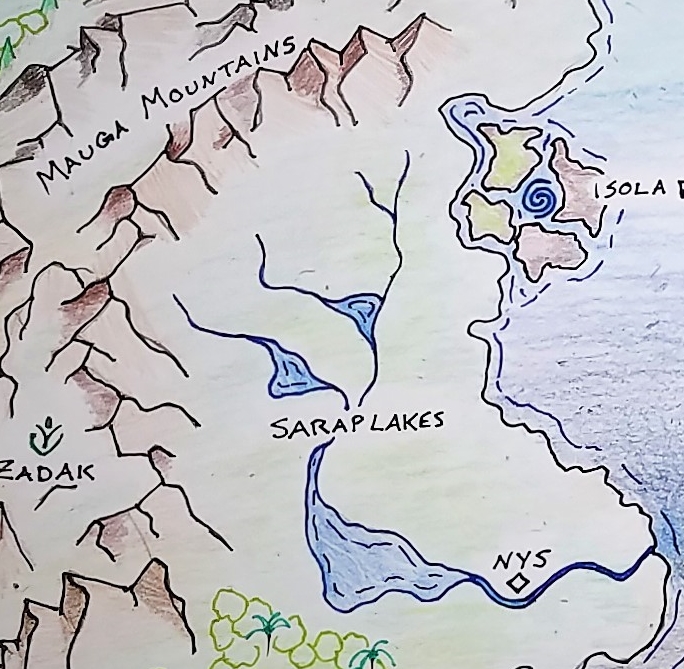
Eventually the farmlands overflow into two main lakes, known as the Upper Lakes. There are yet more farmlands in the plains surrounding them which produce primarily grain and legume crops. There are also small villages dotted around the lake shores who fall under the dominion of Nys, though they are largely left alone. These farmers and those of the Cornucopia rely on the Nysian Road to transport their goods to market in Nys and to receive imported supplies.Lower Sarap River & Nys
Below the Sarap Lake is the main body of the Sarap River which flows all the way to the Marai Sea in a wide swath. The river is wide and deep enough for sailing vessels to come inland from the sea all the way to the city-state of Nys. The city itself sprawls along on both sides of the riverbank, with many man-made piers and harbors jutting out into the water. At times it is impossible to determine where the river ends and the land begins as the bank is entirely covered by boardwalks and buildings on stilts. Ferries frequently cross the width of the river at various points within the city to take traders and travelers from one half of the city to the other. Several attempts have been made to create a bridge to join the two halves of the city, but every design has failed to span the great distance.Sarap Delta
The delta of the Sarap river is almost indistinguishable from the water of the Marai Sea. The river is so wide that many sailors don’t realize they have crossed from salt to fresh water unless they go fishing. It’s banks at this point are so far apart that it’s nearly impossible to see them both at one time. This section of the river can be very rough, restricting passage to sea-going vessels rather than riverboats.Ecosystem
The Sarap River ecosystem is in danger. Native flora has almost entirely been wiped out by commercial agriculture and fisheries have completely mangled the food chain. Each year, as fish are removed from their natural place, insect populations explode and algae overtakes entire sections of the river, making them nearly impassable. Lower, tourist heavy sections of the river are not as affected, but waters in the Upper Lakes are becoming more and more unhealthy. This is causing increased tension between farming and nymph populations, as farmers attempt to expand into fresher waters and nymphs try to drive out the farmers they blame for the imbalance.
Ecosystem Cycles
Annual Flooding
Spring in the Sarap River Basin means floods. Melting ice from the mountains combined with heavy seasonal rains, overflows the farmland and fills the lakes to bursting. Anything bordering the water that isn't on stilts is quickly overtaken and washed downstream. In the dry season (post-harvest), most villages can seem needlessly tall, as buildings built a great distance from the lakes will be high and dry and 20 feet above the ground. But in the spring, these homes can easily have 10-15 feet of water beneath them, and the only means of transport is by canoe or punt. Coincidentally, this is also why the nymphs and villages come into conflict. Homes built in the dry season are often attacked in the wet season, as expanding shorelines bring more territory into the reach of the nymphs. And land previously claimed by nymphs is overrun when the waters recede.Localized Phenomena
On rare nights, when both of the moons of Llyris are dark, a strange bright purple light can be seen shining beneath the surface of Sarap Lake. No human knows the true source of this strange violet light, and if the nymphs know, they are guarding the secret even more closely than their borders. Some say it emanates from the Royal Palace, others say they’ve seen the lights moving through the water, and still more say it shines down from the sky to illuminate the surface. Some say that the lake is always faintly glowing and that it’s just easier to see when the sky is dark. Others say that the glow is so bright that it would drown out the moons. There are even those who deny the light exists and insist that it’s just a local myth. Regardless, it is possible that this brilliant sight will forever be shrouded in mystery.
Fauna & Flora
Fisheries
Farmers on the Sarap River have long 'domesticated' the local freshwater fish, taking native populations and raising them in captive fisheries for harvest. The most popular species of fish is the Purple Trout, with its lavender colored flesh and deep purple eggs, both of which are delicacies. There are several other types of fish being raised as well, but the Purple Trout is the most notable and can only be found in the Sarap River.Agriculture
Where the Prosti Rainforest is a wonderland of indigenous flora, most native plant species in the Sarap River Basin have been cleared for farmland. Grains have replaced grassland and natural topography has been shifted to better suit terraced gardens and patty fields. Commercial growing has made native plants extremely rare, though it has become popular for a few of the wealthier homes in Nys have 'wildflower gardens' featuring these nearly extinct flowers and grasses. The practice of importing flowers from the rainforest is banned however, after an invasive, flowering vine nearly overtook the fields surrounding Nys several decades ago.Natural Resources
The primary natural resources in the Sarap Basin are the fertile soil and rich waters, however at one time granite from the Mauga mountains was the keystone of the local culture. The foundations of Nys, the Nysian Road, and all the walls of the terraces are constructed from slabs of this granite. However, the technique used to mine and transport such slabs has long been lost. Ancient quarries sit abandoned in the heights of the Mauga, but no one knows how the granite was cut from the mountain, or how they moved such massive sections of rock all the way down to Nys. The Nysian Corp currently uses granite gravel left over in the quarries to complete any repairs needed and farmers patch terrace walls with small boulders.
History
Trade, Treaty, & Territorial Dispute
One major hindrance to trade in the Sarap River Basin is the territorial dispute between humans and the river nymphs. The River Nymph nation has long claimed the entirety of Sarap Lake and the section of river between the lake and Nys as their ancestral territory. A treaty exists between the River Nymph nation and Nys, allowing for trade to occur in the city itself, but no one is to trespass on the nymphs' territory. Any boats attempting to travel upriver from Nys are scuttled and sunk before they reach the Sarap Lake. Only the reed punts of the nymphs are permitted to traverse this section of the river and no villages are allowed on the riverbanks or shores of the lake. Any traders hoping to reach the farmers above Sarap Lake, or any farmers attempting to sell their goods in Nys are required to take the Nysian Road. This long highway was cobbled with massive slabs of granite, harvested in the Mauga mountains, back when the treaty was first signed between Nys and the Nymphs. It is patrolled and maintained by the Nysian Corp, a brigade of masons and ex-soldiers commissioned by the Council of Nys, who keep the road passable and safe for all those who wish to trade along its route. Recently, however, the Corp has had trouble recruiting new members, and its aging craftsmen are having a harder time keeping up with repairs and driving off bandits. The farmers in the Upper Lakes region are at still at odds with the River Nymph nation, despite the treaty, as any attempts to build a village on the shores of Sarap Lake are destroyed by the territorial nymphs. A few rebellious groups of nymphs have even tried to destroy villages on the Upper Lakes, resulting in an ongoing feud.Tourism
Riverboats
Because of the sheer width of the Sarap River, the current is generally slow, and the water is gentle once you leave the delta. While the main center channel is reserved for trade vessels, it is not uncommon to see a slew of shallow-bottomed riverboats floating down either side. These 'party barges' and 'pleasure cruises' are popular vacation options for wealthy citizens from all over Llyris and draw thousands of tourists to the markets in Nys. The riverboats range in size from small, open vessels capable of holding half a dozen people and pushed along by poles, to large, multi-story enclosed yachts driven by Mage-wheels. The most opulent riverboat is the Queen Diorah, a two story, gilded wonder commissioned by the king of Pantai for his mistress' birthday. The king used her only once, but she is available to be chartered... for a price.Location
The Sarap Lakes are located on the western continent of Llyris, nestled between the Mauga Mountains and the central Marai Sea. The delta connects the Sarap River to the sea just north of the Prosti Rainforest.Notable City-States
Sarap Lake
The namesake and largest lake in the river system, Sarap Lake is the capitol city of the River Nymphs. This city takes on the form of an iceberg, in that a small portion of it is visible above the water, with floating buildings and bridges all anchored to the Tower. This central tower is actually only the very top of the Royal Palace, with the majority of the building hidden beneath the surface. The Tower and the rest of the Royal Palace is carved into an underwater mountain and the rest of the city is built in a helix pattern around it. 90% of the River Nymph population resides in Sarap Lake, however the Nymphs are one of the very few city-states to have colonies elsewhere on Llyris - small outlying villages in other lakes and deep rivers across the world.
Type
River Basin
Nys
The Sarap River is extremely wide and deep, all the way to the Marai Sea, so Nys is actually considered an inland port. Trading vessels from the eastern continent usually choose to offload their cargo at Nys. The city is formed by two long crescents, one on each bank of the river, and connected by ferry boats. The Nysian Road begins at the peak of the western crescent and travels parallel to the river all the way up to the Upper Lakes. Located halfway between the river delta and Sarap Lake, Nys is a trade post and melting pot for the human and nymph populations. Those few nymphs who chose to dwell on land rather than underwater have made Nys their home, even going so far as to marry humans. Halfling children from these unions are often discriminated against by both the human and nymph populations.Allies & Rivals
The city-state of Nys is close allies with the Zadak Mage school, with many apprentices bringing resources and innovations for farming and working the land. Nys also works in cooperation with the Vurden Mage school, as many riverboats rely on the Mage-wheels manufactured there. The Vurdish Mages are also working as mediators between the River Nymphs and the Council of Nys. Another frequent trade partner is the city-state of Pantai due to the flourishing shipbuilding craft there. Two city-states at odds with Nys are Dealuri and Rynko. Dealuri is a rival trading post on the far side of the Mauga Moutains and is constantly competing with Nys for trade partners. Rynko is currently experiencing a naturalist movement, with many of its people becoming passionate about conservation. This has caused a strained relationship between Vurden (the Mage school closest to Rynko) and Nys, as those in Rynko are pressuring Vurden to stop dealing with Nys until they adopt more conservation-friendly farming practices.Remove these ads. Join the Worldbuilders Guild


SO MUCH DETAIL!!! Everything is so beautifully described and fleshed out from the natural resources to trade to politics. It's great!! ---------------------------------------------------------------- Feel free to check out my Rivers/Waterways entry: Loch Mesner
Thank you.