Ancestor Desert
Ancestor Desert(Vevari name not made yet)
Norra Rorelmi (Crystal Highsands) (Alternate)
Area: 133,566 km2
Elevation: 50m-2800m
Climate Type: Cold Desert
Elevation: 50m-2800m
Climate Type: Cold Desert
(Hot desert in low lying areas)
Temperature Ranges:
Summer: 30-44°C
Winter: -10-24°C
Summer: 30-44°C
Winter: -10-24°C
Population: 280,000 Regalti
Notable Settlement: Arlone-Wreth
Notable Settlement: Arlone-Wreth
Notable Animal Species:
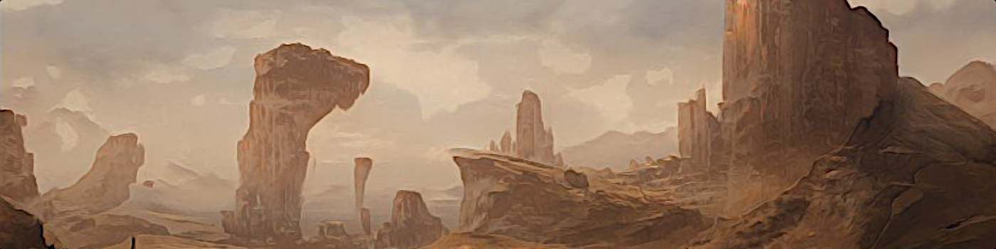
Also called the Crystal Highsands, the Ancestor Desert is a large, isolated desert region in Northern Vefaria. In the distant past, this land was quite a cold, but humid, swampy land, but then the climate changed, and now it's a sandy place that rarely recieves any rain. The Desert is surrounded on all sides by a high plateau with an alpine climate. There are some larger animals that live in the area such as the Crystal Lekira, but the region is mostly inhospitable to larger lifeforms.
This desert is the ancestral home of the Fevarik, and quite possibly many or all the Regalti from the Planet Collena. Imperial Records state that the Fevarik traveled out of the desert around 4000 years ago, making their way to the coastlands, now The Sunken Lands. They directly attribute their origin as being from the moon Sephar.
Old Myths state that we are currently living in the fifth iteration of the universe. At the end of the fourth iteration, the supreme being Ventar came to Collena to see the work his children were doing. What he saw did not please him. While Vala - Goddess of the Sun, and Sevi- Goddess of the Moon were doing their task of bring light to creation, it was the job of many of the other Gods to fill creation with life. Instead, they enslaved the Regalti and made the Regalti build ever larger palaces and monuments to the Gods while the Gods grew lazy. Not all of the gods were doing this, but the ones that were, led by Baultar the Toxic, had infuriated Ventar, who decided that he was going to destroy the universe for a fourth time.
Vala and Sevi took issue with this, as Regalti would also be destroyed with the universe. Vala took many Regalti immediately to Heaven, while Sevi hid many living Regalti with her. When the universe was destroyed and recreated, the Gods returned. Sevi brought the Regalti back to Collena, though many stayed with her. At least, this is what the Sun and Moon Myth say. This myth also explains how Regalti lived on both Collena and Sephar. Most sources agree that it is more complicated than a simple myth, as a supervolcano erupted around the same time, which is what many think caused the collapse of civilization afterwards.
Regardless of what happened, the drying climate forced the Fevarik out. A thousand years later, they reclaimed their ancestral homeland and added it to the Vefaria Empire. In Modern times, the salt flats of the desert are mined for elements such as lithium, and several large corporations have mining rights over the area. Interest in this desert for its resources have greatly decreased over the last few centuries though, as many moons across the The Delvi Star System have far more elemental wealth than this desert ever had.
Somewhere in the center of the desert, there is an old Temple to the Goddesses Vala and Sevi that was built about 2000 years ago. Numerous shrines exist in this area as well.
Location::
 Geography::
 Satellite View::


Nice work. Did you do your own cartography if so what do you use for you map making?
Thanks! Yeah, I did my own cartography, and I did make a full sized map of the continent. You can view that here, but there's no map markers or anything yet. In order to make it...It was a pretty in-depth process with a lot of trial and error, and took about two weeks and all the free time I had:
Spoiler
Lol wow that is a pretty in depth process but we'll worth the effort put into it. Spectacular job. I do my all my own artwork and cartography as well.